
Teesta River is a 414 km (257 mi) long river that rises in the Pauhunri Mountain of eastern Himalayas, flows through the Indian states of Sikkim and West Bengal and subsequently enters Bangladesh through Rangpur division. In Bangladesh, it merges with Jamuna River which after meeting some other major rivers of the Bengal delta finally falls into the Bay of Bengal. It drains an area of 12,540 km2 (4,840 sq mi). In India, the Teesta flows through Mangan District, Gangtok District, Pakyong District, Kalimpong district, Darjeeling District, Jalpaiguri District, Cooch Behar districts and the cities of Rangpo, Jalpaiguri and Mekhliganj. In Bangladesh, it flows through Lalmonirhat District, Rangpur District, Kurigram District and Gaibandha District. It joins the Jamuna River at Phulchhari Upazila in Bangladesh. 305 km (190 mi) of the river lies in India and 109 km (68 mi) in Bangladesh. The Teesta is the largest river of Sikkim and second largest river of West Bengal after the Ganges.
Gaibandha District is a district in northern Bangladesh, located within the Rangpur Division. Covering an area of 2,179.27 square kilometers, it had a population of 2,562,232 as of the 2022 census. The district's administrative headquarters and largest urban center is Gaibandha town. Originally established as a subdivision in 1875 under the name Bhabaniganj, it was renamed Gaibandha in the same year. On February 15, 1984, Gaibandha was officially upgraded to district status. The district is known for its agricultural production, particularly rice, jute, and vegetables, and is situated at the confluence of several major rivers, including the Jamuna, Teesta, and Brahmaputra.

Lalmonirhat District is a District, situated at the northern border of Bangladesh. It is a part of the Rangpur Division. Lalmonirhat mahakuma was established as a district on 1 February 1984. To the north of Lalmonirhat lie Cooch Behar and Jalpaiguri districts of West Bengal; to the south lies Rangpur, to the east lie Kurigram and Cooch Behar; and to the west of lie Rangpur and Nilphamari District. The international border line of Lalmonirhat district is 281.6 km long.

Nilphamari District is a district in Northern Bangladesh. It is a part of the Rangpur Division. It is about 400 kilometers to the northwest of the capital Dhaka. It has an area of 1,580.85 square kilometres (610.37 sq mi). Nilphamari is bounded by Rangpur and Lalmonirhat in east, Rangpur and Dinajpur in south, Dinajpur and Panchagarh in west, Cooch Behar of India in north. The headquarters are in Nilphamari, but the largest city is Saidpur.

The Subarnarekha River flows through the Indian states of Jharkhand, West Bengal and Odisha.

North Bengal or Uttar Banga is a term used for the north-western part of Bangladesh and northern part of West Bengal. The Bangladesh part denotes the Rajshahi Division and Rangpur Division. Generally, it is the area lying west of Jamuna River and north of Padma River and includes the Barind Tract. The West Bengal part denotes Jalpaiguri Division and the Malda division together. The Bihar parts include the Kishanganj district. It also includes parts of Darjeeling Hills. Traditionally, the Ganga River divides Bengal into South Bengal and North Bengal, divided again into Terai and Dooars regions.
The Upper Krishna Project (UKP) is an irrigation project across the Krishna River to provide irrigation to the drought-prone areas of Vijayapura district, Karnataka, Bagalkot, Kalburgi, Yadgir and Raichur districts in the state of Karnataka in south India. The project had been designed by the Government of Karnataka to irrigate 1,536,000 acres of land (6,220 km2).

The Kut Barrage is a barrage on the Tigris river, located in the modern town of Kut in Wasit Governorate, Iraq.
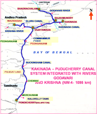
National Waterway 4 (NW-4) is a 1,095 kilometres (680 mi) long waterway in India. It has been declared as an Indian National Waterway and is currently under development. It connects the Indian states of Telangana, Andhra Pradesh, Tamil Nadu, and the union territory of Puducherry. The NW-4 runs along the Coromandal Coast through Kakinada, Eluru, Commanur, Buckingham Canals and also through part of Krishna and Godavari rivers in South India. It was declared a National Waterway on 24 November 2008 under the Provisions of National Waterways Bill, 2006. It is being developed by the Inland Waterways Authority of India (IWAI), and was scheduled for completion by 2013. The National Waterways Act, 2016 has extended the length of NW-4 from 1,095 km (680 mi) to 2,890 km (1,800 mi) by connecting the Krishna and Godavari Rivers. The Project would be undertaken in 3 phases with first phase beginning in October, 2017 and to be completed by June, 2019

The Polavaram Project is an under construction multi-purpose irrigation project on the Godavari River in the Eluru District and East Godavari District in Andhra Pradesh. The project has been accorded National project status by the Central Government of India. Its reservoir back water spreads up to the Dummugudem Anicut and approx 115 km on Sabari River side. Thus back water spreads into parts of Chhattisgarh and Odisha States. It gives major boost to tourism sector in Godavari Districts as the reservoir covers the famous Papikonda National Park, Polavaram hydro electric project (HEP) and National Waterway 4 are under construction on left side of the river. It is located 40 km to the upstream of Sir Arthur Cotton Barrage in Rajamahendravaram City and 25 km from Rajahmundry Airport.

Irrigation in India includes a network of major and minor canals from Indian rivers, groundwater well based systems, tanks, and other rainwater harvesting projects for agricultural activities. Of these groundwater system is the largest. In 2013–14, only about 36.7% of total agricultural land in India was reliably irrigated, and remaining 2/3 cultivated land in India is dependent on monsoons. 65% of the irrigation in India is from groundwater. Currently about 51% of the agricultural area cultivating food grains is covered by irrigation. The rest of the area is dependent on rainfall which is most of the times unreliable and unpredictable.

Mahamaya Irrigation Project is an irrigation project in Bangladesh situated at Durgapur Union, Mirsharai Upazila, Chittagong. Initiated in the 2007-2008 financial year, the project provides irrigation water to a 3360 hectare area. It cost about 230 million taka and construction was completed in 2009. This project was inaugurated by Prime Minister Sheikh Hasina on 29 December 2010. It is the second largest man made lake in Bangladesh after Kaptai Lake.
Lakhwar-Vyasi Dam project on Yamuna River, includes under-construction Lakhwar Dam and Power Station, Vyasi Dam, Hathiari Power Station and Katapathar Barrage, near the Lakhwar town in Kalsi block of Dehradun district of Uttarakhand in India, for the purpose of irrigation of 40,000 hectare land and total 927 MW hydroelectric power generation. "Lakhwar Dam" is a gravity dam near the Lohari village with 300MW power generation capacity. "Vyasi Dam" will be built 5 km downstream along with 120 MW "Hathiari Power Station" further 0.5 km downstream. "Katapathar Barrage", with the maximum ponding water level at 514.5m elevation, will be built further 2.75 km downstream of the Hathiari Power Station to supply the water to stakeholder states. Project will hold 580 million cubic metres water during monsoon and release into Yamuna during dry months.
The North Jiangsu Main Irrigation Canal is located in the lower reaches of the Huai River, one of the major rivers in the north of Jiangsu Province, China. It originates at Gaoliangjian on Hongze Lake and runs through Hongze, Qingpu, Huai'an, Funing, Sheyang and Binghai county(or district) and joins the artificial estuary of Biandan Harbour. The canal is 168 km in length and can irrigate 1,720,000 hectares of farmland. The construction program was organized and directed by the headquarters of the Jiangsu Huai River management program between October 1951 and May 1952.
Western Yamuna Canal is canal in river Yamuna that was dug out and renovated in 1335 CE by Firoz Shah Tughlaq. In 1750 CE, excessive silting caused it to stop flowing. The British raj undertook a three-year renovation in 1817 by Captain GR Blane of the Bengal Engineer Group. In 1832-33 Tajewala Barrage dam at Yamunanagar was also built to regulate the flow of water, and later Pathrala barrage at Dadupur,Yamuna Nagar and Somb river dam downstream of canal were constructed in 1875-76. In 1889-95 the largest branch of the canal Sirsa branch was constructed. The modern Hathni Kund Barrage was built in 1999 to handle the problem of silting to replace the older Tajewala Barrage.

The Kanjirapuzha Dam, a masonry earth dam built for providing irrigation to a Cultural Command Area (CCA) of 9,713 hectares, is located in the Palakkad district in the Indian state of Kerala. The reservoir, which has three islands within it, also has an established commercial fisheries development programme operated by the Fisheries Department.

The Ministry of Water Resources is a ministry of the government of the People's Republic of Bangladesh, which formulates all kinds of policies, plans, strategies, guidelines and laws, rules, regulations, etc. for the development and management of water resources and the management and control of the departments under its jurisdiction. This ministry prepares and implements development projects on flood control, irrigation and drainage, prevention of riverbank erosion, delta development, land reclamation, etc. through the construction of barrages, regulators, sluices, canals, embankments, rubber dams, flood control dams, coastal embankments and canals. Excavation-re-excavation provides services such as irrigation, flood control, flood prevention, river bank erosion prevention, land reclamation etc.
The Palla barrage is a barrage located in Palla on the Yamuna-Faridabad canal in Faridabad district of Haryana state in India. This irrigation canal runs to the west of Yaumna through Fridabad, Palwal, Mathura and Agra districts where it terminates in the farms. Palla, Faridabad is not to be confused with Palla, Delhi, a Yamuna pollution monitoring station 23 km upstream of Wazirabad barrage.

The Muhuri Irrigation Project, commonly referred to as the Muhuri Project, is Bangladesh's second-largest irrigation project. It comprises a closure dam and water control structure, positioned at the confluence of the Feni, Muhuri, and Kalidas-Pahaliya rivers. This project plays a pivotal role in facilitating irrigation and managing floods across areas in Feni and Chittagong districts.

The Teesta Water Dispute involves a geopolitical challenge between India and Bangladesh regarding the allocation of the Teesta River's water resources. Originating in Sikkim, India, and flowing through West Bengal before entering Bangladesh, the Teesta River spans 414 kilometers and is important for agriculture and irrigation, particularly in northern Bangladesh. This river supports the livelihoods of many in the region and is a critical factor in the broader diplomatic relations between the two countries, underscoring the need for collaborative water management strategies.
 Teesta Irrigation Project Canal
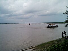 Teesta Irrigation Project
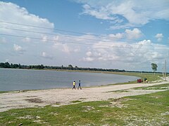
 Teesta Barrage
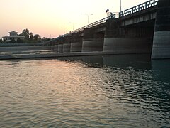 Teesta Barrage
 Sluice Gate of the Teesta Barrage Bangladesh
 Sand Removal Machine in the Teesta Irrigation Project Canal
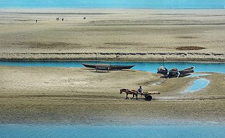
 Main Barrage View from East to West during the Dry Season
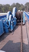 Equipment for Raising and Lowering the Sluice Gate in Teesta Barrage
 Water Stopping Gate in Teesta Barrage
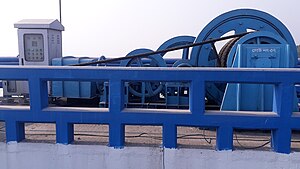 Various Equipment for Raising and Lowering the Water Stopping Gate
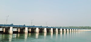 Teesta Barrage from a Distance


