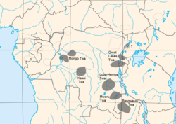
Bangweulu Twa, or the BaTwa of the Bangweulu swamps, are one of several groups of Twa living in Zambia. [1] Others are Kafwe Twa and Lukanga Twa. They are also known by the names BaTwa [2] or Abatwa. [3] While other Twa groups that are scattered across equatorial Africa are described as pygmy groups and averaging about 1.5 m (4 ft 11 in) in height, the Bangweulu Twa are described as taller and at least partly of Bantu origin [4] [5] but they may be the descendants of former hunter-gatherer groups. [6] [7]
After the coming of various outside Bantu groups to the area, groups of Twa moved to swamps and marsh land territories in Zambia. [8] In descriptions from the early 20th century Bangweulu Twa are said to live off the land, they had no domestic animals but cultivated around ant-hills and on other raised patches. Through trade with inland neighbours they got meal and grain. [4] [9]
Eric von Rosen visited the Twa during his expedition in Bangweulu during 1911 and 1912 and calls them the "Swamp people". [10] [9] Von Rosen collected ethnographica and took photographs which are today in Sweden at the Museum of Ethnography in Stockholm and the Museum of World Culture in Gothenburg.
After von Rosens expedition the Lake dwellers have been steadily moving to the main land. Sleeping-sickness did play an important part in this process. [11] [8]
Zambia, officially the Republic of Zambia is a landlocked country at the crossroads of Central, Southern and East Africa, although it is typically referred to as being in Southern Africa at its most central point. Its neighbours are the Democratic Republic of the Congo to the north, Tanzania to the north-east, Malawi to the east, Mozambique to the southeast, Zimbabwe and Botswana to the south, Namibia to the southwest, and Angola to the west. The capital city of Zambia is Lusaka, located in the south-central part of Zambia. The population is concentrated mainly around Lusaka in the south and the Copperbelt Province to the north, the core economic hubs of the country.
The history of Zambia experienced many stages from colonization to independence from Britain on October 24, 1964. Northern Rhodesia became a British sphere of influence in the present-day region of Zambia in 1888, and was officially proclaimed a British protectorate in 1924. After many years of suggested mergers, Southern Rhodesia, Northern Rhodesia, and Nyasaland were merged into the British Federation of Rhodesia and Nyasaland.
Lake Mweru is a freshwater lake on the longest arm of Africa's second-longest river, the Congo. Located on the border between Zambia and Democratic Republic of the Congo, it makes up 110 kilometres (68 mi) of the total length of the Congo, lying between its Luapula River (upstream) and Luvua River (downstream) segments.
The Bemba language, ChiBemba, is a Bantu language spoken primarily in north-eastern Zambia by the Bemba people and as a lingua franca by about 18 related ethnic groups, including the Bisa people of Mpika and Lake Bangweulu, and to a lesser extent in Katanga in the Democratic Republic of the Congo and Tanzania. Including all its dialects, Bemba is the most spoken indigenous Bantu language and a lingua franca in Zambia where the Bemba form the largest ethnic group. The Lamba language is closely related and some people consider it a dialect of Bemba.
Bangweulu — 'where the water sky meets the sky' — is one of the world's great wetland systems, comprising Lake Bangweulu, the Bangweulu Swamps and the Bangweulu Flats or floodplain. Situated in the upper Congo River basin in Zambia, the Bangweulu system covers an almost completely flat area roughly the size of Connecticut or East Anglia, at an elevation of 1,140 m straddling Zambia's Luapula Province and Northern Province. It is crucial to the economy and biodiversity of northern Zambia, and to the birdlife of a much larger region, and faces environmental stress and conservation issues.
The Luapula River is a section of Africa's second-longest river, the Congo. It is a transnational river forming for nearly all its length part of the border between Zambia and the DR Congo. It joins Lake Bangweulu to Lake Mweru and gives its name to the Luapula Province of Zambia.
The Kalambo Falls on the Kalambo River is a 772-foot (235 m) single-drop waterfall on the border of Zambia and Rukwa Region, Tanzania at the southeast end of Lake Tanganyika. The falls are some of the tallest uninterrupted falls in Africa. Downstream of the falls is the Kalambo Gorge, which has a width of about 1 km and a depth of up to 300 m, running for about 5 km before opening out into the Lake Tanganyika rift valley. The Kalambo waterfall is the tallest waterfall in both Tanzania and Zambia. The expedition which mapped the falls and the area around it was in 1928 and led by Enid Gordon-Gallien. Initially it was assumed that the height of falls exceeded 300 m, but measurements in the 1920s gave a more modest result, above 200 m. Later measurements, in 1956, gave a result of 221 m. After this several more measurements have been made, each with slightly different results. The width of the falls is 3.6–18 m.
The Bangweulu Wetlands is a wetland ecosystem adjacent to Lake Bangweulu in north-eastern Zambia. The area has been designated as one of the world's most important wetlands by the Ramsar Convention, and an "Important Bird Area" by BirdLife International. African Parks began managing Bangweulu in partnership with Zambia's Department of National Parks and Wildlife with the establishment of the Bangweulu Wetland Management Board in August 2008.
The Bemba belong to a large group of Bantu peoples mainly in the Northern, Luapula, Muchinga, and the Northern part of Central Province of Zambia. Some people mistake the Lambas speaking people of the copper belt who trace their origin from the Luba-lunda kingdom to say they are related to the Bemba of Northern province. The two are not related in any way just like the French are not related to the English. The Lamba traditional and culture is totally different from the Bemba traditional and culture. The Lamba drum beat and dance is the same as that of the Kaonde of North Western provinve, Kaonge, Mantyatya and Shonongo, while the Bemba have the Imbeni and other types of dance and drum beat. The Bemba entered modern-day Zambia through crossing the Luapula River at Chipya in the Senior Chief Matanda's Chiefdom in Mansa, Luapula Province and that Chief Matanda and his Ushi people were the first to come into Zambia by the year 1328 from Kola. The collection of ethnicities known as Bemba have a ruling class called Abena Ng'andu. This clan traces its ancestry to Mbemba Nshinga who ruled Kongo from 1509–1543. Mbemba was called King Afonso l by the Portuguese whom he hosted in his kingdom for many years. They are one of the larger ethnic groups in Zambia. (A few other ethnic groups in the Northern, Luapula, and Copperbelt provinces of Zambia speak languages that are similar to Bemba but are not necessarily the same. For example, although the Lamba have the same roots as the Bemba, they never relied on the Bemba aristocracy for leadership. Indeed the Bemba people are not strictly indigenous to the Copperbelt Province, having come to the copper belt province in the 1930s. They went there large numbers in search of employment opportunities brought about by the opening up of the large scale copper mining activities. In contrast members of the Bisa royal family are almost all descendants of Chitimukulu, as are many members of the Swaka and Lala aristocracies. Bemba history is a major historical phenomenon in the development of chieftainship in a large and culturally homogeneous region of central Africa.
Kazembe is a traditional kingdom in modern-day Zambia, Southeastern Congo. For more than 250 years, Kazembe has been an influential kingdom of the Kiluba-Chibemba, speaking the language of the Eastern Luba-Lunda people of south-central Africa. Its position on trade routes in a well-watered, relatively fertile and well-populated area of forestry, fishery and agricultural resources drew expeditions by traders and explorers who called it variously Kasembe, Cazembe and Casembe.
Audrey Isabel Richards, CBE, FRAI, FBA, was a pioneering British social anthropologist. She produced notable ethnographic studies. The most famous of which is Chisingu: A Girl's initiation ceremony among the Bemba of Zambia.
The Congo Pedicle is the southeast salient of the Katanga Province of the Democratic Republic of Congo, which divides neighbouring Zambia into two lobes. In area, the pedicle is similar in size to Wales or New Jersey. 'Pedicle' is used in the sense of 'a little foot'. 'Congo Pedicle' or 'the Pedicle' is also used to refer to the Congo Pedicle road which crosses it.
The following outline is provided as an overview of and topical guide to Zambia:
Zambia, officially known as the Republic of Zambia, is a landlocked country in Southern Africa. The neighbouring countries are the Democratic Republic of the Congo to the north, Tanzania to the north-east, Malawi to the east, Mozambique, Zimbabwe, Botswana, and Namibia to the south, and Angola to the west. The capital city is Lusaka, located in the southeast of the country. The population is concentrated mainly around the capital and the Copperbelt to the northwest.
The Livingstone Museum, formerly the David Livingstone Memorial Museum and after that, the Rhodes-Livingstone Museum, is the largest and the oldest museum in Zambia, located in Livingstone near Victoria Falls. The museum has exhibits of artifacts related to local history and prehistory, including photographs and musical instruments, and also holds possessions and memorabilia - including letters and journals - of David Livingstone, the explorer and missionary.
The Rhodes-Livingstone Institute (RLI) was the first local anthropological research facility in Africa; it was founded in 1937 under the initial directorship of Godfrey Wilson. It is located a few miles outside Lusaka. Designed to allow for easier study of the local cultures of Northern Rhodesia, now Zambia, it became the base of operations for a number of leading anthropologists of the time.
The Congo Pygmies are those "forest people" who have, or recently had, a hunter-gatherer economy and a simple, non-hierarchical societal structure based on bands, are of short stature, have a deep cultural and religious affinity with the Congo forest and live in a generally subservient relationship with agricultural "patrons", with which they trade forest products such as meat and honey for agricultural and iron products.
The Twa are a group of indigenous African Pygmy tribes.
The Ninth German Inner Africa Research Expedition was led by Leo Frobenius to Southern Africa between August 1928 and March 1930. It visited modern-day South Africa, Zimbabwe, Botswana, Lesotho, Mozambique, Namibia and Zambia. It recorded a large quantity of indigenous rock art, which helped Frobenius to build one of the most important collections of such work, some of which was sold to South African museums. It also investigated ancient ore mines and provided samples for some of the first metallographic and chemical analysis of southern African indigenous metals.
Lenje people is an ethnic group in Zambia. They are loosely bound with its spatial and cultural boundaries shifting, depending on whom you talk to. They live mainly in the Central province but also in Lusaka and Copperbelt province. It is not clear when they arrived to the area where they live today but they are believed to be among the first people to come to Zambia from the Cameroon region. It has been claimed that they have been in the area at least since the 17th century. The Lenje chiefdom comprises one senior chief and seven subordinate chiefs and chiefdoms. They are about 240 000 - 310 000 and are considered to be part of the Bantu, Central-South people cluster within the Sub-Saharan African affinity bloc. They are related to the neighboring Tonga people and have also been said to be related to the Twa of the Lukanga Swamps.
{{cite journal}}
: Cite journal requires |journal=
(help)