Bangweulu Wetlands

Last updated
Bangweulu Wetlands
Bangweulu Swamps
Bangweulu Swamps.jpg
View of the wetlands
Zambia relief location map.jpg
Red pog.svg
Location of the Bangweulu Wetlands in Zambia
Coordinates 11°36′S30°05′E / 11.600°S 30.083°E / -11.600; 30.083
Area9,850 km2 (3,800 sq mi)
Designated28 August 1991
Reference no.531 [1]

The Bangweulu Wetlands is a wetland ecosystem adjacent to Lake Bangweulu in north-eastern Zambia. The area has been designated as one of the world's most important wetlands by the Ramsar Convention and an "Important Bird Area" by BirdLife International. African Parks began managing Bangweulu in partnership with Zambia's Department of National Parks and Wildlife with the establishment of the Bangweulu Wetland Management Board in 2008.

Contents

Overview

The Bangweulu Wetlands ecosystem was first described in the 1940s. [2] Bangweulu, which means "where the water meets the sky", is located mostly within Zambia's Northern Province and recognized by the Ramsar Convention as one of the world's most important wetlands. [3] The 9,850-square-kilometre (3,800 sq mi) [4] region has floodplains, seasonally flooded grasslands, woodlands, [5] and permanent swamps fed by the Chambeshi, Luapula, Lukulu, and Lulimala rivers. [3] The nonprofit conservation organization African Parks manages a 6,000-square-kilometre (2,300 sq mi) area of the greater Bangweulu ecosystem. [6]

Flora and fauna

The ecosystem has Cyperus papyrus , floating grasses, miombo woodland, [7] and reeds that support large populations of crocodiles, fish, and water birds. Mammals include buffalo, Burchell's zebra, bushbuck, common tsessebe, elephants, hippopotamus, hyenas, jackals, oribi, reedbuck, roan and sable antelope, and sitatunga. [3] [5] [7] [8] Bangweulu has the only remaining significant population of the black lechwe; [9] There were an estimated 36,600 reported in 2020. [5] Millions of straw-coloured fruit bats migrate to Bangweulu's Mushitu swamp forest in Kasanka National Park. [10] In 2016, African Parks partnered with Fondation Segré to relocate 600 animals, including hartebeest, impala, and puku, into the wetlands. [11] Cheetahs were reintroduced to the reserve in late 2020, almost a century after their absence. [12]

20160605 0400 Bangweulu Bec-ouvert africain.jpg
20160605 0196 Bangweulu Hirondelle a collier.jpg
20160604 0015 Bangweulu Grue caronculee.jpg
20160605 0253 Bangweulu Guepier a collier bleu (cropped).jpg
A variety of bird species live in Bangweulu, including the African openbill, banded martin, blue-breasted bee-eater, and wattled crane (displayed clockwise from top left), photographed in the wetlands in 2016

Bangweulu has been designated as an "Important Bird Area" by BirdLife International. [5] The wetlands are home to more than 400 bird species, [7] including cormorants, ducks, egrets, geese, herons, ibises, pygmy goose, and waders. [3] Most notable is the shoebill, a vulnerable species threatened by habitat burning for farming, competition with fisheries, wildlife trade, and other disturbances. [3] [13] In May 2022, the Shoebill Captive Rearing and Rehabilitation Facility was established. [14] The facility cares for chicks then release them back to the region. Other species recorded in Bangweulu include the great white pelican, saddle-billed stork, African spoonbill, and wattled crane. [3] [15]

Human–wildlife conflict

Bangweulu encompasses several villages, and an estimated 50,000–90,000 people depend on the wetlands, resulting in human–wildlife conflict. [3] [16] The ecosystem is threatened by habitat burning for farming, overfishing, and poaching. [3] The increased use of mosquito nets for fishing has decreased fish populations in Bangweulu and throughout Zambia. [17] To combat these problems, African Parks developed several community programs and enterprise projects, including bee-keeping, sustainable fisheries management, and reproductive health education. As a result, poaching and other illegal activities have been largely contained, and fish stocks have managed to recover.

Conservation

In 2008, African Parks began managing Bangweulu with the establishment of the Bangweulu Wetland Management Board, which includes representation by African Parks, the Zambia Wildlife Authority, and six community members. [3] Funding was secured by African Parks and the United Nations Development Programme (UNDP). Through this partnership, African Parks is responsible for all management and operations of Bangweulu, including law enforcement, community development, biodiversity conservation, infrastructure and economic development. [3] This public-private and community partnership is part of the Community Partnership Park concept created by the Ministry of Lands, Natural Resources and Environment Protection and Zambia Wildlife Authority's "Reclassification and Effective Management of National Protected Areas System" project. [5] According to UNDP, the project seeks to "improve the management of existing Protected Areas through law enforcement and to propose new protected area categories to ensure the community owns and manages the natural resources in a sustainable manner". [5]

Past partners supporting Bangweulu Wetlands include the Bangweulu Wetlands Management Board and Kasanka Trust; current major funders supporting Bangweuu include WWF-The Netherlands, WWF-Zambia, and the Zambian Department of National Parks and Wildlife, according to African Parks. [3] [18] The Working for Water Project's mission is to survey and protect Africa's major wetlands, including Bangweulu, the Niger and Okavango deltas, and Sudd and Zambezi. [3] The University of Cape Town's Percy FitzPatrick Institute of African Ornithology has worked to create conservation plans for the shoebill. [3] African Parks and Fondation Segré's "Bangweulu Wetlands Wildlife Reintroduction Project" was initiated in 2016 and seeks to "recreate an ecologically viable protected area with the capacity to become sustainable". [11]

See also

Related Research Articles

<span class="mw-page-title-main">Swamp</span> A forested wetland

A swamp is a forested wetland. Swamps are considered to be transition zones because both land and water play a role in creating this environment. Swamps vary in size and are located all around the world. The water of a swamp may be fresh water, brackish water, or seawater. Freshwater swamps form along large rivers or lakes where they are critically dependent upon rainwater and seasonal flooding to maintain natural water level fluctuations. Saltwater swamps are found along tropical and subtropical coastlines. Some swamps have hammocks, or dry-land protrusions, covered by aquatic vegetation, or vegetation that tolerates periodic inundation or soil saturation. The two main types of swamp are "true" or swamp forests and "transitional" or shrub swamps. In the boreal regions of Canada, the word swamp is colloquially used for what is more formally termed a bog, fen, or muskeg. Some of the world's largest swamps are found along major rivers such as the Amazon, the Mississippi, and the Congo.

<span class="mw-page-title-main">Shoebill</span> Species of bird

The shoebill, also known as the whalebill, whale-headed stork, and shoe-billed stork is a large long-legged wading bird. It derives its name from its enormous shoe-shaped bill. It has a somewhat stork-like overall form and has previously been classified with the storks in the order Ciconiiformes based on this morphology. However, genetic evidence places it with pelicans and herons in the Pelecaniformes. The adult is mainly grey while the juveniles are more brown. It lives in tropical East Africa in large swamps from South Sudan to Zambia.

<span class="mw-page-title-main">Lake Bangweulu</span> Lake in Zambia

Bangweulu — 'where the water sky meets the sky' — is one of the world's great wetland systems, comprising Lake Bangweulu, the Bangweulu Swamps and the Bangweulu Flats or floodplain. Situated in the upper Congo River basin in Zambia, the Bangweulu system covers an almost completely flat area roughly the size of Connecticut or East Anglia, at an elevation of 1,140 m straddling Zambia's Luapula Province and Northern Province. It is crucial to the economy and biodiversity of northern Zambia, and to the birdlife of a much larger region, and faces environmental stress and conservation issues.

<span class="mw-page-title-main">Caroni Swamp</span> Largest mangrove wetland in Trinidad and Tobago

The Caroni Swamp is the largest mangrove wetland in Trinidad and Tobago. It is located on the west coast of Trinidad, south of Port of Spain and northwest of Chaguanas, where the Caroni River meets the Gulf of Paria.

<span class="mw-page-title-main">Liuwa Plain National Park</span> National park in Zambia

Liuwa Plain National Park is a 3,369-square-kilometre (1,301 sq mi) national park in Zambia's Western Province. "Liuwa" means "plain" in the local Liuwa language, a dialect of Lozi language, and the plains originally served as a hunting ground for Lubosi Lewanika, the Litunga of the Lozi people. The area was designated as a protected area by Lubosi Lewanika in the early 1880s, and as a national park in 1972, when Zambia's government took over management. The nonprofit conservation organization African Parks has managed Liuwa in partnership with the Department of National Parks and Wildlife and the Barotse Royal Establishment since 2003.

<span class="mw-page-title-main">Kasanka National Park</span> National Park in Zambias Central Province

Kasanka National Park is a park located in the Chitambo District of Zambia’s Central Province. At roughly 390 km2 (150 sq mi), Kasanka is one of Zambia’s smallest national parks. Kasanka was the first of Zambia’s national parks to be managed by a private-public partnership. The privately funded Kasanka Trust Ltd has been in operation since 1986 and undertakes all management responsibilities, in partnership with the Department of National Parks and Wildlife. The park has an average elevation between 1,160 m (3,810 ft) and 1,290 m (4,230 ft) above mean sea level. It has a number permanent shallow lakes and water bodies with the largest being Wasa. There are five perennial rivers in the park, with the largest being the Luwombwa River. The Luwombwa is the only river that drains the NP, which flows out in the northwestern corner. It is a tributary of the Luapula, which further upstream also drains the Bangweulu Swamp and forms the main source of the Congo River. Although Kasanka NP is part of the Greater Bangweulu Ecosystem, there is no direct hydrological connection between the park and the Bangweulu Wetlands.

The Kafue Flats are a vast area of swamp, open lagoon and seasonally inundated flood-plain on the Kafue River in the Southern, Central and Lusaka provinces of Zambia. They are a shallow flood plain 240 km (150 mi) long and about 50 km (31 mi) wide, flooded to a depth of less than a meter in the rainy season, and drying out to a clayey black soil in the dry season.

<span class="mw-page-title-main">Lukanga Swamp</span> Major wetland in Zambia

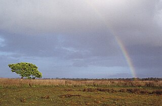
Lukanga Swamp is a major wetland in the Central Province of Zambia, about 50 km west of Kabwe. Its permanently swampy area consists of a roughly circular area with a diameter of 40 to 50 km covering 1850 km2, plus roughly 250 km2 in the mouths of and along rivers discharging into it such as the Lukanga River from the north-east, plus another 500 km2 either side of the Kafue River to the west and north-west, making 2600 km2 in total. It contains many lagoons such as Lake Chiposhye and Lake Suye but few large channels, and its average depth is only 1.5 m.

<span class="mw-page-title-main">Wildlife of Zambia</span>

The wildlife of Zambia refers to the natural flora and fauna of Zambia. This article provides an overview, and outline of the main wildlife areas or regions, and compact lists of animals focusing on prevalence and distribution in the country rather than on taxonomy. More specialized articles on particular groups are linked from here.

<span class="mw-page-title-main">Zambezian flooded grasslands</span> Flooded grassland ecoregion in Africa

The Zambezian flooded grasslands is an ecoregion of southern and eastern Africa that is rich in wildlife.

<span class="mw-page-title-main">Barotse Floodplain</span> Major floodplain in Central Africa

The Barotse Floodplain, also known as the Bulozi Plain, Lyondo or the Zambezi Floodplain, is one of Africa's great wetlands, on the Zambezi River in the Western Province of Zambia. It is a designated Ramsar site, regarded as being of high conservation value.

<span class="mw-page-title-main">Wasur National Park</span> National park in Indonesia

The Wasur National Park forms part of the largest wetland in Merauke Regency, South Papua, Indonesia and has been one of the least disturbed by human activity. The high value of its biodiversity has led to the park being dubbed the "Serengeti of Papua". The vast open wetland, in particular Rawa Biru Lake, attracts a very rich fauna.

<span class="mw-page-title-main">Whangamarino Wetland</span> Wetland of international importance under the Ramsar Convention

The Whangamarino Wetland in the Waikato District is the second largest wetland complex of the North Island of New Zealand. Encompassing a total area of more than 7200 hectares, the Department of Conservation Te Papa Atawhai manages 5,923 hectares of peat bog, swamp, mesotrophic lags, open water and river systems listed as a wetland of international importance under the Ramsar Convention. Fish and Game New Zealand are the second largest landowner, managing 748 hectares of the wetland primarily as gamebird hunting habitat.

Isangano National Park is a national park in the Northern Province of Zambia. It covers an area of 840 square kilometers. The park was declared a national park in 1972. It went into decline due to problems caused by human settlement and lack of funds. This has resulted in little wildlife and game in the park. In July 2007, steps were taken to address these problems.

The Point Cook Coastal Park covers an area of 863 hectares and includes the Cheetham Wetlands. The park extends from the RAAF Williams Point Cook Base northeast along the coast to the Laverton creek which comprises its northern boundary. The park is approximately 20 kilometres (12 mi) from Melbourne, Australia in a southwesterly direction along Port Phillip Bay. The park is adjoined by the Point Cook Marine Sanctuary, which extends around the point to the south and the east. The northwestern boundary to the park is residential housing.

Lavushi Manda National Park is a national park in the Muchinga Province of Zambia with an area of 1,500 sq km. It is the 11th largest of the 20 National Parks in Zambia. The park was initially gazetted as a Game Reserve in 1941, and was declared a National Park in 1972. It is located in a district of the same name (Lavushimanda), with the South Luangwa National Park in the neighbouring Mpika District. It is adjacent to Bangweulu Game Management Area to the northwest, Kafinda Game Management Area lies further west. The chiefdom of Chiundaponde is in the northwest, north lies Luchembe, northwest Chikwanda, east Mpumba, and south lies Muchinka chiefdom. It covers a small range of mountains and hills, and is principally covered in miombo woodlands, with a number of rivers and streams, and a few areas of grassland, both on drier land or in the form of seasonally wet dambos. There are few large mammals, due to poaching in the previous century, but fishing and hiking are possible. Certain antelope species retreat upland to the park from the Bangweulu swamps to the northwest during the rainy season.

<span class="mw-page-title-main">Lunga District</span> District in Luapula Province, Zambia

Lunga District is one of the newly created districts in the Luapula Province of Zambia. It was declared a district in 2012 by Michael Sata. The district comprises archipelago of islands in the Bangweulu Wetlands in the South East of Lake Bangweulu.

References

  1. "Bamgweulu Swamps". Ramsar Sites Information Service. Retrieved 10 January 2024.
  2. McKey, Doyle B.; Durécu, Mélisse; Pouilly, Marc; Béarez, Philippe; Ovando, Alex; Kaleb, Mashuta; Huchzermeyer, Carl F. (27 December 2016). "Present-day African analogue of a pre-European Amazonian floodplain fishery shows convergence in cultural niche construction". Proceedings of the National Academy of Sciences of the United States of America . 113 (52): 14, 938–14, 943. doi: 10.1073/pnas.1613169114 . OCLC   43473694. PMC   5206554 . PMID   27980030.
  3. 1 2 3 4 5 6 7 8 9 10 11 12 13 Boyes, Steve (7 December 2012). "Working for Water: The Bangweulu Wetlands and Africa's Shoebill…". National Geographic. Retrieved 10 October 2017.
  4. Gray, William (2007). Zambia and Victoria Falls. New Holland Publishers. p. 91. ISBN   9781845378134 . Retrieved 10 October 2017.
  5. 1 2 3 4 5 6 "Bangweulu Wetlands "Where the water meets the sky"". United Nations Development Programme. Archived from the original on 19 May 2019. Retrieved 10 October 2017.
  6. "Bangweulu Wetlands" (PDF). African Parks . Retrieved 4 December 2017.
  7. 1 2 3 Fitzpatrick, Mary; Grosberg, Michael; Holden, Trent; Morgan, Kate; Ray, Nick; Waters, Richard (1 June 2013). Lonely Planet Zambia, Mozambique & Malawi. Lonely Planet. p. 204. ISBN   9781743216453 . Retrieved 10 October 2017.
  8. Chisha, Christine (23 October 2016). "Malama set to make a difference". Zambia Daily Mail . Retrieved 11 October 2017.
  9. Kamweneshe, Bernard Mwila (2002). Ecology, Conservation and Management of the Black Lechwe (Kobus Leche Smithemani) in the Bangweulu Basin, Zambia. University of Pretoria . Retrieved 11 October 2017.
  10. Weaver, Tony (11 November 2011). "Eight Million New Wonders of the World". Cape Times . Cape Town: Sekunjalo Investments. Archived from the original on 3 April 2018. Retrieved 11 October 2017.
  11. 1 2 "Bangweulu Wetlands Wildlife Reintroduction Project". Fondation Segré. Retrieved 10 October 2017.
  12. "Zambia Hails the Return of Cheetahs to one of Africa's Most Important Wetlands". www.africanparks.org. Retrieved 2023-05-23.
  13. Shoebill:
  14. "Shoebill Conservation in Bangweulu - A Unique Solution for a Unique Bird". African Parks. Retrieved 20 February 2024.
  15. Kamweneshe, Bernard M. "Status of Ecology of Wattled Cranes in Bangweulu Basin, Zambia" (PDF). pp. 261–265. Retrieved 10 October 2017 via International Crane Foundation.
  16. McIntyre, Chris (5 July 2016). Zambia. Bradt Travel Guides. p. 336. ISBN   9781784770129 . Retrieved 11 October 2017.
  17. Gettleman, Jeffrey (24 January 2015). "Meant to Keep Malaria Out, Mosquito Nets Are Used to Haul Fish In". The New York Times . ISSN   0362-4331. OCLC   1645522 . Retrieved 11 October 2017.
  18. "Partners: Bangweulu". African Parks. Retrieved 11 October 2017.

Further reading

External videos
Nuvola apps kaboodle.svg Video: Zambia's Bangweulu Wetlands, National Geographic Society