
Himachal Pradesh is a state in the northern part of India. Situated in the Western Himalayas, it is one of the thirteen mountain states and is characterized by an extreme landscape featuring several peaks and extensive river systems. Himachal Pradesh is the northernmost state of India and shares borders with the union territories of Jammu and Kashmir and Ladakh to the north, and the states of Punjab to the west, Haryana to the southwest, Uttarakhand to the southeast and a very narrow border with Uttar Pradesh to the south. The state also shares an international border to the east with the Tibet Autonomous Region in China. Himachal Pradesh is also known as Dev Bhoomi, meaning 'Land of God' and Veer Bhoomi which means 'Land of Braves'.

Dharamshala is the winter capital of Himachal Pradesh, India. It serves as administrative headquarters of the Kangra district after being relocated from Kangra, a city located 18 km (11 mi) away from Dharamshala, in 1855.

Manali is a town in the Indian state of Himachal Pradesh. It is situated in the northern end of the Kullu Valley, formed by the Beas River. The town is located in the Kullu district, approximately 270 kilometres (170 mi) north of the state capital of Shimla and 544 kilometres (338 mi) northeast of the national capital of Delhi. With a population of 8,096 people recorded in the 2011 Indian census Manali is the beginning of an ancient trade route through Lahaul and Ladakh, over the Karakoram Pass and onto Yarkand and Hotan in the Tarim Basin of China. Manali is a popular tourist destination in India and serves as the gateway to the Lahaul and Spiti district as well as the city of Leh in Ladakh.

Hastinapur is a city in the Meerut district in the Indian state of Uttar Pradesh. Hastinapura, described in Hindu texts such as the Mahabharata and the Puranas as the capital of the Kuru Kingdom, is also mentioned in ancient Jain texts. Hastinapur is located on the right bank of the Ganga river.

Nahan is a town in Himachal Pradesh in India and is the headquarters of the Sirmaur District It was the capital of the former Sirmur princely state.
Satna is a city in the Indian state of Madhya Pradesh. It serves as the headquarters of Satna district. It is 6th largest city and 8th most populous city of the state. The city is 500 km east of the state capital Bhopal. The city is distributed over a land area of 111.9 square kilometres.

Kangra is a city and a municipal council in Kangra district in the Indian state of Himachal Pradesh. It is also known as Nagarkot.

Pathankot is a city and the district headquarters of the Pathankot district in Punjab, India. Pathankot is the 6th most populous city of Punjab, after Ludhiana, Amritsar, Jalandhar, Patiala and Bathinda. Its local government is a municipal corporation.
Paonta Sahib is an industrial town of Himachal Pradesh in India. It is located in the south of Sirmaur district, on National Highway 72. Paonta Sahib is an important place of worship for Sikhs, hosting a large Gurdwara named Gurudwara Paonta Sahib, on the banks of the river Yamuna. The river is the boundary between the states of Himachal Pradesh and Uttarakhand.
Gagret is a nagar panchayat in Tehsil Ghanari of Una district in the state of Himachal Pradesh, India. It is situated in plains of Una.
Sarkaghat is a hilly town, a Nagar Panchayat and a Tehsil in the Indian state of Himachal Pradesh.
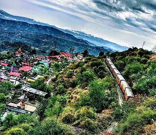
Jogindernagar, or Jogindar Nagar, is a municipality in Mandi district in the Indian state of Himachal Pradesh. Named after Raja Joginder Sen, the hill station is the terminus of the 163-kilometre-long (101 mi) Kangra Valley narrow-gauge railway. Jogindernagar is the third-largest city in the district. The only city in Asia with three hydro-electric power stations, its nickname is "The City of Powerhouses".
Pubowal is a village in Una district in the Indian state of Himachal Pradesh.

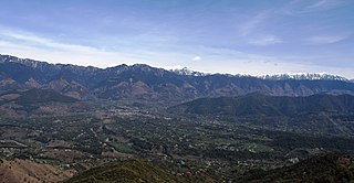
Kangra Valley is a river valley situated in the Western Himalayas. It lies in the state of Himachal Pradesh in India, and is a popular tourist destination. The Kangri dialect is spoken there. Dharamshala, the headquarters of Kangra district and the main city of the valley, lies on the southern spur of Dhauladhar.

Hanswar is a town in the Ambedkar Nagar district of Uttar Pradesh, India, located east of Tanda. Demographically, Hanswar resembles the rest of the Purvanchal area in which it is located.
Jawali is a town in Kangra District of Himachal Pradesh State in India.Old name of Jawali is Jawanwalashehar. Jawali is the second largest Assembly constituency in the state of Himachal Pradesh. It is located 250 km distance from its State Capital, Shimla and is located 50 km distance from its District headquarters Dharamshala.
Totu is one of the major suburbs of Shimla city, in the state of Himachal Pradesh, India. It is under the administration of the Shimla Municipal Corporation.

Aadi Himani Chamunda is a Hindu temple dedicated to Shri Chamunda Devi, situated in Chandar Bhan, Jia in Kangra Valley, Himachal Pradesh, India, in the Himalayas.
Bamta is a panchayat in Chopal in the district of Shimla, Himachal Pradesh, India.

Nankhari is a Tehsil (town) and a block in Shimla district in the Indian state of Himachal Pradesh. It is about 92.5 km from Shimla and 33 km from Narkanda and NH 5. It consists of 17 Gram panchayat and 102 villages.


