Banié

Last updated
Banié
Sub-prefecture and town
Guinea adm location map.svg
Red pog.svg
Banié
Location in Guinea
Coordinates: 7°23′N9°23′W / 7.383°N 9.383°W / 7.383; -9.383
CountryFlag of Guinea.svg  Guinea
Region Nzérékoré Region
Prefecture Yomou Prefecture
Time zone GMT (UTC+0)

Banié is a town and sub-prefecture in the Yomou Prefecture in the Nzérékoré Region of south-eastern Guinea. [1]

Town settlement that is bigger than a village but smaller than a city

A town is a human settlement. Towns are generally larger than villages but smaller than cities, though the criteria to distinguish them vary considerably between different parts of the world.

Sub-prefectures of Guinea

The sub-prefectures are the third-level administrative divisions in Guinea. As of 2009 there were 303 rural communes of Guinea and 38 urban communes, 5 of which compose the Conakry greater urban area; Kaloum, Dixinn, Matam, Ratoma and Matoto.

Yomou Prefecture Prefecture in Nzérékoré Region, Guinea

Yomou is a prefecture located in the Nzérékoré Region of Guinea. The capital and principal town of the prefecture is Yomou. The prefecture covers an area of 3,920 km.² and has an estimated population of 114,371.

Related Research Articles

Kankan Sub-prefecture and town in Kankan Region, Guinea

Kankan (Mandingo: Kánkàn) is the largest city in Guinea in land area, and the third largest in population, with a population of 193,830 people as of 2014. The city is located on the Milo River in eastern Guinea and lying about 345 miles east of Conakry.

Lola Prefecture Prefecture in Nzérékoré Region, Guinea

Lola is a prefecture located in the Nzérékoré Region of Guinea. The capital is Lola. The prefecture covers an area of 4,688 km.² and has a population of 171,561.

Macenta Prefecture Prefecture in Nzérékoré Region, Guinea

Macenta is a prefecture located in the Nzérékoré Region of Guinea. The capital is Macenta. The prefecture covers an area of 7,056 km.² and has an estimated population of 278,456.

Kankan Prefecture Prefecture in Kankan Region, Guinea

Kankan is a prefecture located in the Kankan Region of Guinea. The capital is Kankan. The prefecture covers an area of 19,750 km.² and has a population of 473,359.

Siguiri Prefecture Prefecture in Kankan Region, Guinea

Siguiri is a prefecture located in the Kankan Region of Guinea. The capital is Siguiri. The prefecture covers an area of 18,500 km2 (7,100 sq mi) and has a population of 687,002.

Kérouané Prefecture Prefecture in Kankan Region, Guinea

Kérouané is a prefecture located in the Kankan Region of Guinea. The capital is Kérouané. The prefecture covers an area of 7,020 km.² and has a population of 207,547.

Coyah Prefecture Prefecture in Kindia Region, Guinea

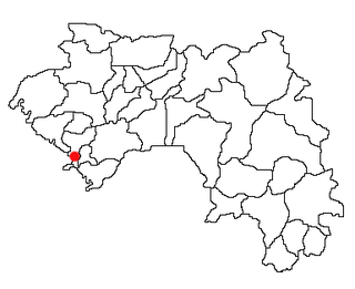
Coyah is a prefecture located in the Kindia Region of Guinea. The capital is Coyah. The prefecture covers an area of 1,375 km.² and has a population of 263,861.

Dubréka Prefecture Prefecture in Kindia Region, Guinea

Dubréka is a prefecture located in the Kindia Region of Guinea. The capital is Dubréka. The prefecture covers an area of 4,350 km² and has a population of 330,548.

Coyah Sub-prefecture and town in Kindia Region, Guinea

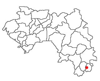
Coyah is a town and sub-prefecture located in western Guinea. It is the capital of Coyah Prefecture. Population 77,103.

Guingan Sub-prefecture and town in Boké Region, Guinea

Guingan is a town and sub-prefecture in the Koundara Prefecture in the Boké Region of northern Guinea. As of 2014 it had a population of 14,347 people.

Linko, Guinea Sub-prefecture and town in Kankan Region, Guinea

Linko is a town and sub-prefecture in the Kérouané Prefecture in the Kankan Region of south-eastern Guinea. As of 2014 it had a population of 16,478 people.

Garambé Sub-prefecture and town in Labé Region, Guinea

Garambé is a town and sub-prefecture in the Labé Prefecture in the Labé Region of northern-central Guinea.

Sérédou Sub-prefecture and town in Nzérékoré Region, Guinea

Sérédou is a town and sub-prefecture in the Macenta Prefecture in the Nzérékoré Region of south-eastern Guinea.

Tolo, Guinea Sub-prefecture and town in Mamou Region, Guinea

Tolo, Guinea is a town and sub-prefecture in the Mamou Prefecture in the Mamou Region of Guinea.

Bourouwal-Tappé Sub-prefecture and town in Mamou Region, Guinea

Bourouwal-Tappé is a town and sub-prefecture in the Pita Prefecture in the Mamou Region of northern-central Guinea.

Kintinian Sub-prefecture and town in Kankan Region, Guinea

Kintinian is a town and sub-prefecture in the Siguiri Prefecture in the Kankan Region of northern Guinea.

Konah Sub-prefecture and town in Labé Region, Guinea

Konah is a town and sub-prefecture in the Tougué Prefecture in the Labé Region of northern-central Guinea.

Sinématiali Department Department in Savanes, Ivory Coast

Sinématiali Department is a department of Poro Region in Savanes District, Ivory Coast. In 2014, its population was 58,612 and its seat is the settlement of Sinématiali. The sub-prefectures of the department are Bouakaha, Kagbolodougou, Sédiogo, and Sinématiali.

Facobly Department Department in Montagnes, Ivory Coast

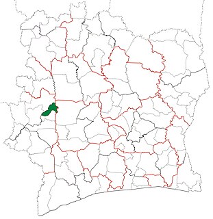
Facobly Department is a department of Guémon Region in Montagnes District, Ivory Coast. In 2014, its population was 76,507 and its seat is the settlement of Facobly. The sub-prefectures of the department are Facobly, Guézon, Koua, Sémien, and Tiény-Séably.

References

  1. "Subprefectures of Guinea". Statoids. Retrieved April 20, 2009.

Coordinates: 7°23′N9°23′W / 7.383°N 9.383°W / 7.383; -9.383

Geographic coordinate system Coordinate system

A geographic coordinate system is a coordinate system that enables every location on Earth to be specified by a set of numbers, letters or symbols. The coordinates are often chosen such that one of the numbers represents a vertical position and two or three of the numbers represent a horizontal position; alternatively, a geographic position may be expressed in a combined three-dimensional Cartesian vector. A common choice of coordinates is latitude, longitude and elevation. To specify a location on a plane requires a map projection.