
Conakry is the capital and largest city of Guinea. A port city, it serves as the economic, financial and cultural centre of Guinea. Its population as of the 2014 Guinea census was 1,660,973 Originally situated on Tombo Island, one of the Îles de Los, it has since spread up the neighboring Kaloum Peninsula.
Beyla is one of Freyr's servants along with her husband, Byggvir, in Norse mythology. Beyla is mentioned in stanzas 55, 66, and the prose introduction to the Poetic Edda poem Lokasenna. Since this is the only mention of Beyla, scholars have turned to the etymology of Beyla's name for additional information about her. However, the meaning of her name is unclear and her name has been proposed as related to "cow," "bean," or "bee."
ISO 3166-2:GN is the entry for Guinea in ISO 3166-2, part of the ISO 3166 standard published by the International Organization for Standardization (ISO), which defines codes for the names of the principal subdivisions of all countries coded in ISO 3166-1.

Guinea is divided into 8 regions among which the national capital Conakry ranks as a special zone. The other 7 regions are further subdivided into 33 prefectures and thence into communes.

Boké is the capital city of Boké Prefecture within the Boké Region of Lower Guinea near the border with Guinea-Bissau. It is also a sub-prefecture of Guinea. Located along the Rio Nuñez which flows to its not-too-distant mouth on the Atlantic Ocean, Boké is a port. It is known for the Fortin de Boké museum, formerly a slave fort. The town is served by Boké Baralande Airport. As of 2014 the city and surrounding sub-prefecture had a population of 61,449 people.

The Nzérékoré Region is a region in the southern part of Guinea. Its capital and largest city is Nzérékoré. It is one of the eight regions of Guinea. It is bordered by the countries of Sierra Leone, Liberia, and Ivory Coast, and the Guinean regions of Kankan and Faranah.

The Faranah Region is located in east-central Guinea. It is bordered by the countries of Sierra Leone and Mali and the Guinean regions of Kankan, Mamou, Nzérékoré, and Labé.

The Boké Region is located in western Guinea. It is bordered by the countries of Senegal and Guinea-Bissau and the Guinean regions of Kindia and Labé. Its capital is the city of Boké.

Lélouma is a prefecture located in the Labé Region of Guinea. The capital is Lélouma. The prefecture covers an area of 2,140 km.² In census of 2014, it had population of 163,000.

Boffa is a prefecture located in the Boké Region of Guinea. The capital is Boffa. The prefecture covers an area of 5,050 km2 (1,950 sq mi) and has a population of 212,583.

Koundara is a prefecture located in the Boké Region of Guinea. The capital is Koundara. The prefecture covers an area of 5,238 km.² and has a population of 130,205.

The Mamou Region is located in central Guinea. It is bordered by the country of Sierra Leone and the Guinean regions of Faranah, Labé, and Kindia.

The Kindia Region is located in western Guinea. It is bordered by the country of Sierra Leone and the Guinean regions of Conakry, Labé, Mamou, and Boké.

The Labé Region is located in north-central Guinea. It is bordered by the countries of Senegal and Mali and the Guinean regions of Faranah, Kindia, Mamou, and Boké.
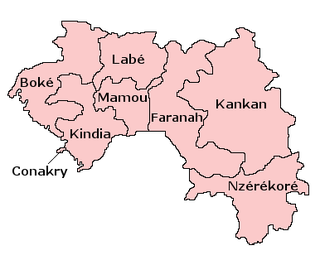
Guinea is divided into 8 administrative regions which are further subdivided into 34 prefectures.
Kamsar is a port city in Guinea, West Africa. It is also a Sub-prefecture of Guinea. It is located on the mouth of the Nunez River. As of 2014, the sub-prefecture had a population of 113,350 people. The city population was 61,527.
Womey is a town and sub-prefecture in the Nzérékoré Prefecture in the Nzérékoré Region of Guinea.

Guinea is divided into four natural regions with distinct human, geographic, and climatic characteristics:


