
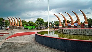
Banjarnegara is a town in Central Java, Indonesia and the seat of Banjarnegara Regency. It is 55 km from the Dieng Plateau region and a centre for ceramic arts.
Banjarnegara is a town in Central Java, Indonesia and the seat of Banjarnegara Regency. It is 55 km from the Dieng Plateau region and a centre for ceramic arts.
Banjarnegara has a tropical rainforest climate (Af) with moderate rainfall from June to September and heavy to very heavy rainfall from October to May. It is one of the wettest towns in Indonesia.
| Climate data for Banjarnegara | |||||||||||||
|---|---|---|---|---|---|---|---|---|---|---|---|---|---|
| Month | Jan | Feb | Mar | Apr | May | Jun | Jul | Aug | Sep | Oct | Nov | Dec | Year |
| Average high °C (°F) | 29.3 (84.7) | 29.6 (85.3) | 29.9 (85.8) | 29.9 (85.8) | 29.9 (85.8) | 29.8 (85.6) | 29.4 (84.9) | 29.7 (85.5) | 30.1 (86.2) | 30.4 (86.7) | 29.6 (85.3) | 29.2 (84.6) | 29.7 (85.5) |
| Daily mean °C (°F) | 25.0 (77.0) | 25.2 (77.4) | 25.5 (77.9) | 25.5 (77.9) | 25.4 (77.7) | 24.9 (76.8) | 24.1 (75.4) | 24.4 (75.9) | 24.9 (76.8) | 25.4 (77.7) | 25.2 (77.4) | 24.9 (76.8) | 25.0 (77.1) |
| Average low °C (°F) | 20.8 (69.4) | 20.8 (69.4) | 21.1 (70.0) | 21.2 (70.2) | 21.0 (69.8) | 20.0 (68.0) | 18.9 (66.0) | 19.1 (66.4) | 19.7 (67.5) | 20.4 (68.7) | 20.9 (69.6) | 20.6 (69.1) | 20.4 (68.7) |
| Average rainfall mm (inches) | 498 (19.6) | 433 (17.0) | 557 (21.9) | 455 (17.9) | 315 (12.4) | 122 (4.8) | 119 (4.7) | 98 (3.9) | 113 (4.4) | 294 (11.6) | 488 (19.2) | 546 (21.5) | 4,038 (158.9) |
| Source: Climate-Data.org [1] | |||||||||||||
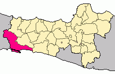
Cilacap Regency is a regency in the southwestern part of Central Java province in Indonesia. Its capital is the town of Cilacap.

Wonosobo Regency is a regency in Central Java province in Indonesia. Its capital is the town of Wonosobo, located at 7.3684940°S 109.8983841°E, about 120 km from Semarang. The regency is located in the town of Wonosobo on the Dieng Plateau. Its area is 984.68 km2 and its population was 754,883 at the 2010 census and 879,124 at the 2020 census; the official estimate as at mid 2022 was 923,793.
Demak is a town in Central Java, Indonesia. It is the capital of Demak Regency and the location of the former Sultanate of Demak, briefly the strongest power on the island of Java. The town covers an area of 61.13 km2, and had a population of 110,165 at the 2020 Census.

Pangandaran is a town and district of Pangandaran Regency within the province of West Java, Indonesia. It is located on the southern coast of the island of Java. A well-known surfing beach has made Pangandaran a popular tourist destination.

Cibinong is a large town and district in Bogor Regency, West Java, Indonesia which serves as the Regency's seat. It is located immediately due south of the city of Depok, which itself lies south of Jakarta, with both Depok and Cibinong being part of the Jakarta Metropolitan Area. Cibinong District had 363,424 inhabitants at the 2020 Census, and the official estimate as at mid 2022 was 370,928.

Dieng Plateau is a plateau in Central Java, Indonesia that forms the floor of the caldera complex on the Dieng Volcanic Complex. Administratively, this plateau is included in the territory of Banjarnegara Regency and Wonosobo Regency. Covers agricultural areas that have a subtropical climate with high levels of rainfall.

Temanggung Regency is an inland regency in the Central Java Province of Indonesia. It covers a land area of 870.65 km2 and had a population of 708,546 at the 2010 Census and 790,174 at the 2020 Census; the official estimate as at mid 2022 was 799,764, comprising 402,114 males and 397,650 females. Its capital is the town of Temanggung.
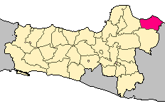
Rembang Regency is a regency on the extreme northeast coast of Central Java Province, on the island of Java in Indonesia. The regency covers an area of 1,036.70 km2 on Java, and it had a population of 591,359 at the 2010 Census and 645,333 at the 2020 Census; the official estimate as at mid 2022 was 650,770, of whom 327,196 were males and 323,574 were females. Its administrative capital is the town of Rembang.
Sragen Regency is a regency in the eastern part of Central Java province in Indonesia. It covers an area of 994.57 km2 and had a population of 858,266 at the 2010 Census and 976,951 at the 2020 Census; the official estimate as at mid 2022 was 992,243. Its capital is the town of Sragen, located about 30 km to the northeast of Surakarta. Sragen is bordered by East Java Province to the east.

The Manuk River is a river in West Java, Indonesia, about 170 km east of the capital Jakarta.
Pemali River is a river in northern Central Java, Indonesia, about 250 km east of the capital Jakarta.
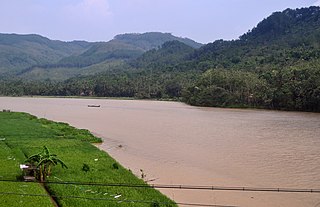
The Serayu River is a river in Central Java, Indonesia, about 300 km southeast of the capital Jakarta.

On 13 December 2014, a landslide in Banjarnegara, Central Java, Indonesia, killing 93 with 23 people missing. The disaster occurred on Jemblung Village in Banjarnegara, Indonesia, at Friday, around 03.00 p.m. At the time, most of the villagers were taking a nap on their houses. The landslides also trapped some vehicles on the road. Amateur video caught the moment when a large piece of the mountain fell to the whole village. Indonesian authority said that at least around 100 people are feared dead and 300 houses were destroyed.
Kebumen is a town on the island of Java, Indonesia and is the administrative centre of Kebumen Regency, in Central Java Province. It is also the name of the main town of the district of Kebumen. The population of the town at the 2010 Census was 118,847, while the 2020 Census gave a total of 131,750; the official estimate as at mid 2022 was 133,030. Kebumen has other names - "Swallow City", "City Tours", and "the city of culture".
Kudus is the capital and the namesake of the Kudus Regency in Central Java, Indonesia. Its name has an Arabic etymology connected to its foundation by the legendary figure Sunan Kudus. It also houses the mosque established by Sunan Kudus named Menara Kudus Mosque, one of the most important and influential mosques in Indonesia. According to the 2010 census, its population was 92,776, but by mid 2022 this had declined to 88,635.

Mandiraja is a district (kecamatan) in Banjarnegara Regency, Central Java, Indonesia. The district has an area of 52.62 km², with a population of 78,090 people at the 2020 Indonesian population census. Mandiraja is also 6 km east of the General Sudirman Airport.
Purwasaba is a village in Mandiraja Town, Banjarnegara Regency, Central Java Province, Indonesia. This village has an area of 282,16 hectares and a population of 5.665 inhabitants in 2010.
Mandirajakulon is a village in the town Mandiraja Banjarnegara Regency, Central Java Province, Indonesia. This village has an area of 177,97 hectares and a population of 5.652 inhabitants in 2010.
Banjengan is a village in the town of Mandiraja, Banjarnegara Regency, Central Java Province, Indonesia. This villages has an area of 124.68 hectares and a population of 2,120 inhabitants in 2010.

Glempang is a village in the town of Mandiraja Banjarnegara Regency, Central Java Province, Indonesia. This villages has an area of 569,91 hectares and a population of 4.965 inhabitants in 2010.
| International | |
|---|---|
| National | |
| Other | |
7°23′46″S109°41′42.58″E / 7.39611°S 109.6951611°E
| | This Central Java location article is a stub. You can help Wikipedia by expanding it. |