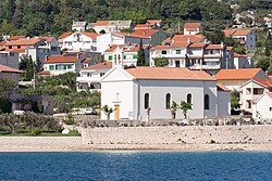
Barbat na Rabu | |
|---|---|
Village | |
 | |
 Barbat na Rabu | |
| Coordinates: 44°44′N14°49′E / 44.733°N 14.817°E | |
| Country | |
| County | Primorje-Gorski Kotar |
| Municipality | Rab |
| Area | |
• Total | 23.9 km2 (9.2 sq mi) |
| Population (2021) [2] | |
• Total | 1,140 |
| • Density | 47.7/km2 (124/sq mi) |
| Time zone | UTC+1 (CET) |
| • Summer (DST) | UTC+2 (CEST) |
Barbat na Rabu is a village on the island of Rab, Croatia. It is connected by the D105 highway.