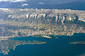
Rab (town)

Last updated
Rab
Town
Rab1.jpg
Historic town center of Rab
Croatia location map.svg
Red pog.svg
Rab
Location of Rab within Croatia
Coordinates: 44°45′22″N14°45′40″E / 44.75611°N 14.76111°E / 44.75611; 14.76111
CountryFlag of Croatia.svg  Croatia
County Flag of Primorje-Gorski Kotar County.png Primorje-Gorski Kotar
Island Rab
Government
  MayorNikola Grgurić (HDZ)
  City Council
15 members
Area
[1]
  Town75.9 km2 (29.3 sq mi)
  Urban
0.4 km2 (0.2 sq mi)
Elevation
0 m (0 ft)
Population
 (2021) [2]
  Town7,161
  Density94/km2 (240/sq mi)
   Urban
364
  Urban density910/km2 (2,400/sq mi)
Time zone UTC+1 (CET)
  Summer (DST) UTC+2 (CEST)
Postal code
51 280
Area code 051
Website rab.hr

Rab (Italian : Arbe, Latin : Arba) is a town (grad) on the island of Rab in Croatia. According to the 2011 census the total population of the town was 8,065, whereas only 437 lived in the titular settlement (naselje). Rab, the settlement, is located on a small peninsula on the southwestern side of the island.

Contents

The town has a long history that dates back to 360 BC when it was inhabited by the Illyrians. The island was the frontier between the regions of Liburnia and Dalmatia. From the third century BC to the sixth century AD Rab was part of the Roman Empire, and Emperor Augustus proclaimed it a municipium in 10 BC. It was the first town of Roman Dalmatia to be given the honorary title "felix".

Among the signatories of the Second Council of Nicea was a bishop of Rab, namely Ursus. (“Ursus episcopus Avaritianensium ecclesiae” Ursus of Rab) [3] [4]

The worst disaster in the town's history was an outbreak of the plague in 1456 that decimated the city's population.

There are many churches in the town. The largest is St. Mary the Blessed, which was built in the 13th century. The church of St. Justine is now a museum of sacred arts, while the chapel of St. Christopher (dedicated to the patron saint of the island) is nowadays called the Lapidarium. The four church bell towers became the symbol of the town and island. The oldest dates back to the eleventh century.

Saint Marinus, the Christian founder of San Marino, was a native of Rab who is said to have fled the island under Diocletian's persecution in AD 301.

Population

Town of Rab: Population trends 1857–2021
population
3589
3952
4279
4525
4465
5099
5099
6352
7230
7757
7849
8041
8496
9205
9480
8065
7161
18571869188018901900191019211931194819531961197119811991200120112021

International relations

Rab is twinned with:

Related Research Articles

<span class="mw-page-title-main">Dalmatia</span> Historical region of Croatia

Dalmatia is one of the four historical regions of Croatia, alongside Central Croatia, Slavonia and Istria, located on the east shore of the Adriatic Sea in Croatia.

<span class="mw-page-title-main">Trogir</span> Town in Split-Dalmatia, Croatia

Trogir is a historic town and harbour on the Adriatic coast in Split-Dalmatia County, Croatia, with a population of 10,923 (2011) and a total municipal population of 13,192 (2011). The historic city of Trogir is situated on a small island between the Croatian mainland and the island of Čiovo. It lies 27 kilometres west of the city of Split.

<span class="mw-page-title-main">Split-Dalmatia County</span> County in southern Croatia

Split-Dalmatia County is a central-southern Dalmatian county in Croatia. The administrative center is Split. The population of the county is 455,242 (2011). The land area is 14.106,40 km2. Split-Dalmatia County is Croatia's most rapidly urbanising and developing region, as economic opportunities and living standards are among the highest alongside capital Zagreb and Istria County.

<span class="mw-page-title-main">Rab</span> Island in Croatia

Rab [ɾâːb] is an island in the northern Dalmatia region in Croatia, located just off the northern Croatian coast in the Adriatic Sea.

<span class="mw-page-title-main">Pula</span> City in Istria County, Croatia

Pula, also known as Pola, is the largest city in Istria County, Croatia, and the seventh-largest city in the country, situated at the southern tip of the Istrian peninsula in northwestern Croatia, with a population of 52,220 in 2021. It is known for its multitude of ancient Roman buildings, the most famous of which is the Pula Arena, one of the best preserved Roman amphitheaters. The city has a long tradition of wine making, fishing, shipbuilding, and tourism. It was the administrative centre of Istria from ancient Roman times until superseded by Pazin in 1991.

<span class="mw-page-title-main">Korčula</span> Island of Croatia

Korčula is a Croatian island in the Adriatic Sea. It has an area of 279 km2 (108 sq mi), is 46.8 km (29.1 mi) long and on average 7.8 km (4.8 mi) wide, and lies just off the Dalmatian coast. Its 15,522 inhabitants (2011) make it the second most populous Adriatic island after Krk. The population are almost entirely ethnic Croats (95.74%). The island is twinned with Rothesay in Scotland. It is known for Grk, a white wine that is only produced here and not exported due to limited production.

<span class="mw-page-title-main">Makarska</span> City in Split-Dalmatia, Croatia

Makarska is a town on the Adriatic coastline of Croatia, about 60 km (37 mi) southeast of Split and 140 km (87 mi) northwest of Dubrovnik, in the Split-Dalmatia County.

Stari Grad is a town on the northern side of the island of Hvar in Dalmatia, Croatia. One of the oldest towns in Europe, its position at the end of a long, protected bay and next to prime agricultural land has long made it attractive for human settlement. Stari Grad is also a municipality within the Split-Dalmatia County.

<span class="mw-page-title-main">Novalja</span> Town in Lika-Senj, Croatia

Novalja is a town in the north of the island of Pag in the Croatian part of Adriatic Sea. In recent times, Novalja has become famous because of the Zrće Beach.

<span class="mw-page-title-main">Lastovo</span> Island in Croatia

Lastovo is an island municipality in the Dubrovnik-Neretva County in Croatia. The municipality consists of 46 islands with a total population of 792 people, of which 94,7% are ethnic Croats, and a land area of approximately 53 square kilometres (20 sq mi). The biggest island in the municipality is also named Lastovo, as is the largest town. The majority of the population lives on the 46 square kilometres (18 sq mi) island of Lastovo.

<span class="mw-page-title-main">Cavtat</span> Village in Dubrovnik-Neretva County, Croatia

Cavtat is a village in the Dubrovnik-Neretva County of Croatia. It is on the Adriatic Sea coast 15 kilometres south of Dubrovnik and is the centre and the main settlement of Konavle municipality.

<span class="mw-page-title-main">Mošćenice</span> Village in Mošćenička Draga, Croatia

Mošćenice is a village in the municipality of Mošćenička Draga in Primorje-Gorski Kotar County on the Istrian peninsula, close to Opatija, Croatia.

<span class="mw-page-title-main">Lumbarda</span> Village and municipality of Croatia

Lumbarda is a village and a municipality located on the eastern tip of Korčula in Croatia, seven kilometers away from the town of Korčula. A road passing through a picturesque area of pine woods and olive groves connects these two places. Lumbarda is surrounded by sandy vineyards and sandy beaches such as Vela Pržina, Bilin Žal and Tatinja. Lumbarda is a tourist centre, many of its 1,200 inhabitants are active in the local tourist service but they are also wine-growers, fishermen and stone-dressers. Lumbarda has a rich history preserved in written documents dating back to more than 2,000 years ago.

<span class="mw-page-title-main">Supetar</span> Town in Split-Dalmatia, Croatia

Supetar is a town on the northern side of the Dalmatian island of Brač, in the Split-Dalmatia County, in Croatia. It became the island's official centre in 1827. The Town of Supetar includes Supetar itself and the three villages: Splitska, Škrip and Mirca.

<span class="mw-page-title-main">Tisno</span> Municipality in Šibenik-Knin, Croatia

Tisno is a town and municipality in Šibenik-Knin County, Croatia.

<span class="mw-page-title-main">Baška Voda</span> Municipality in Split-Dalmatia County, Croatia

Baška Voda is a municipality in Croatia in the Split-Dalmatia County. It has a population of 2,775, 96.2% of which are Croats. It is located on the Adriatic coastline of Dalmatia 10 km northwest of Makarska.

<span class="mw-page-title-main">Jelsa, Croatia</span> Municipality in Split-Dalmatia County, Croatia

Jelsa is a town in Croatia, on the island of Hvar, the seat of the eponymous municipality (općina) within the county of Split-Dalmatia.

<span class="mw-page-title-main">Donji Humac</span> Place in Split-Dalmatia, Croatia

Donji Humac is one of the oldest settlements on the Croatian island of Brač, located on an inland hill. The top of the hill is marked by a widely visible baroque bell-tower. The nearby Kopačina cave has been inhabited more than 13,200 years ago. As of the 2011 census, Donji Humac has a population of 177 - far below its largest extent at the beginning of the 20th century with more than 500 people, before several waves of emigration depopulated the settlement.

Croatian art describes the visual arts in Croatia, and art by Croatian artists from prehistoric times to the present. In Early Middle Ages, Croatia was an important centre for art and architecture in south eastern Europe. There were many Croatian artists during the Medieval period, and the arts flourished during the Renaissance. Later styles in Croatia included Baroque and Rococo.

<span class="mw-page-title-main">Dalmatian city-states</span> Dalmatian localities where the local Romance population survived the Barbarian invasions

Dalmatian city-states were the Dalmatian localities where the local Romance population survived the Barbarian invasions after the fall of the Western Roman Empire in the 400s CE. Eight little cities were created by those autochthonous inhabitants that maintained political links with the Eastern Roman Empire. The original names of these cities were Jadera, Spalatum, Crespa, Arba, Tragurium, Vecla, Ragusium, and Cattarum. The language and the laws were initially Latin, but after a few centuries, they developed their own Neo-Latin language, Dalmatian, which lasted until the 19th century. The cities were maritime centres with huge commerce, mainly with the Italian peninsula and with the growing Republic of Venice.

References

  1. Register of spatial units of the State Geodetic Administration of the Republic of Croatia. Wikidata   Q119585703.
  2. "Population by Age and Sex, by Settlements, 2021 Census". Census of Population, Households and Dwellings in 2021. Zagreb: Croatian Bureau of Statistics. 2022.
  3. Basić, Ivan (2018). New evidence for the re-establishment of the Adriatic dioceses in the late eighth century. Oxford. pp. 261–287. ISBN   978-1-138-22594-7.{{cite book}}: CS1 maint: location missing publisher (link)
  4. Škegro, Ante. The Sarnian diocese (Sarniensis Ecclesia) (PDF).
  5. "Ricorre quest'anno il 50° anniversario del gemellaggio San Marino-Arbe - San Marino Fixing" (in Italian). 17 October 2023. Retrieved 2024-01-13.

Attribution