Skrad was first mentioned on 22 February 1481 in a document freeing the citizens of Grič from tariffs in Skrad and elsewhere, unless the other Skrad was intended.[3]
In 1860–1879, Matija Mažuranić wrote a 62 folio manuscript today titled Writings on the Building of Roads in Gorski Kotar and Lika (Croatian: Spisi o gradnji cesta u Gorskom Kotaru i Lici), today with signature HR-ZaNSKR 6424. A 21 folio manuscript dated 1872 titled Darstellung der Entstehung des Baues ... der Luisenstrasse togethr with a translation by I. Mikloušić is kept as HR-ZaNSKR 4572.[4]:223
After the Lujzijana was built, the Družtvo lujzinske ceste constructed an inn in Skrad together with stables and an aqueduct. In 1874, the society would sell all its assets along the road, including those in Skrad.[5]
Kingdom of Yugoslavia
The volunteer fire department DVD Skrad was founded on 1 March 1932,[6] and is today part of the Požarno područje Gorski kotar IV. Its current commander is Davor Štimac.[7]
The local chapter of the HPS is HPD "Skradski Vrh", which had 21 members in 1936 under the Josip Lončarić presidency.[8] No data was shared for 1937.[9]:227 Membership fell to 13 in 1938 under the Vinko Janeš presidency.[10]:224,249 Membership remained at 13 in 1939 under the Josip Žagar presidency.[11]:240,262
Since the inclusion of Ski jumping at the 1924 Winter Olympics, the sport grew in popularity. In 1934, a ski jump was opened below Skradski Vrh for jumps up to 28 metres (92ft). The project was headed by J. Lončarić, the ski jump designed by a Norwegian engineer and built by the local "Skradski Vrh" Cooperation on two parcels of land. It was the first ski jump on the territory of the ZZSP. Though in 1935, Delnice would build its own.[12][8] The ski jump was opened in 1939.[11]
WWII
In October 1941, the Minister of Sport and Mountaineering of the NDH, Miško Zebić, named Josip Žagar as the state povjerenik of the HPD "Skradski Vrh", and designated as the chapter's advisory board: Juraj Jugović, Stjepan Rauh, Vinko Janeš, Andrija Rački, Josip Grgurić and Milan Štimac.[13] The HPD "Skradski Vrh" was officially renamed Hrvatsko planinarsko društvo u Skradu in March 1942,[14]:52 but Gospić did not reply to the order.[15]
The Domobrani had a hospital here during the war. On 29 July 1942, Partisans attacked the hospital, but the attack was repelled by the Domobrani.[16]
At 19:00 on 11 September, a group of around 1000 Partisans attacked a guard stationed at the power plant consisting of 20 Domobrans of the 25th company of the 3rd Regiment of the Second Division[hr], capturing the plant and blowing it up with explosives, leaving Brod Moravice, Delnice and Skrad without electricity.[17]
Recent
From 31 January to 2 February 2014, while S and SW geostrophic wind dominated,[18]freezing rain fell on Gorski Kotar, glazing the entire region. It wrecked roofs, power lines an forests, causing power loss for about 14,000 households households in Gorski Kotar, or about 80% of its population. It took about 10 days to restore essential infrastructure to the region, and within months electricity was back in most of its former range, but at a cost of about 84.4 million HRK to HEP. At the time it was the largest peacetime damage since its Secession from Yugoslavia, even without counting the forestry losses. The Šumarija Skrad lost 2% of its wood mass.[19] Clearing blocked forestry roads and forest paths would take years, and thanks to the declining population some were never cleared.[20]
On 12 December 2017, a severe wind hit Skrad, blocking traffic to and from it along the Kupjak-Stubica road.[21][22]
Climate
From 1960 to 1993, the highest temperature recorded at the local weather station was 33.7°C (92.7°F), on 28 July 1983.[23] The coldest temperature was −19.8°C (−3.6°F), on 8 January 1985.[24]
In 1870, Skrad općina, in Delnicepodžupanija, had 906 houses, with a population of 6107 (largest in the podžupanija). Its 60 villages were divided into 5 porezne obćine (Divjake, Bukov Vrh, Brod Moravice, Završje, Komorske Moravice) for taxation purposes. Parishes included Divjake, Brod Moravice, Završje and the Eastern Orthodox parish of Komorske Moravice.[26]:9,12–13
In 1895, the obćina of Skrad (court at Skrad), with an area of 51 square kilometres (20sqmi), belonged to the kotar of Delnice (Delnice court and electoral district) in the županija of Modruš-Rieka (Ogulin court and financial board). There were 337 houses, with a population of 2048. Its 25 villages and 1 hamlet were divided for taxation purposes into 2 porezne obćine, under the Delnice office.[27]:iv,v
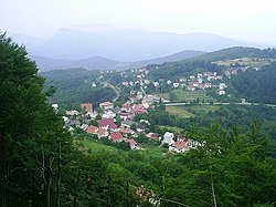
In the 2011 census, there were 1,062 inhabitants, in the following settlements:[2][28]
On 1 July 1893, Skrad obćina was divided into Skrad with tax districts Bukov Vrh and Divjake, and Brod-Moravice with tax districts Brod-Moravice and Završje.[31]:209
The 4,536 metres (14,882ft)Perivoj mladih garden was planted in 1920.[33]
Vražji prolaz
Vražji prolaz/Zeleni vir has been protected since 1962.[33]
The 800 metres (2,600ft) path along Vražji prolaz/Zeleni vir was built in the 1930s and 1960s.[33]
Sports
Bowling
Skrad is home to the bowling club Skrad, which meets at the Kuglana Zeleni Vir.[34] The best bowlers of Skrad have competed in the 2nd League, and the local individual record at the bowling alley is 637, set in 2008 by Bore Juričević.[34]
Cycling
Beginning in 2013,[35] the 7 stage 260 kilometres (160mi) long Cycling Trail of Gorski Kotar (Croatian: Goranska biciklistička transverzala) passes through Skrad, where the second stage ends.[36]
The "Gorski Kotar Bike Tour", held annually since 2012,[37] sometimes goes through Skrad, such as in the third leg for 2023.[38]
↑ Trošić, Tanja; Mokorić, Marija (2014). ""Ledena kiša" i poledica u Gorskom kotaru od 31. siječnja do 5. veljače 2014". Meteorološki i hidrološki bilten (4): 49–53. ISSN1334-3017.
↑ Kraljevski zemaljski statistički ured (1877). "Glavni pregled sudbenoga razdieljenja kraljevinah Hrvatske i Slavonije". Pregled političkoga i sudbenoga razdieljenja kraljevinah Hrvatske i Slavonije i uredjenja upravnih obćinah. Na temelju naredbe kr. hrv.-slav.-dalm. zem. vlade od 5. veljače 1875. broj 221 pr. i provedenoga zatim zaokruženja upravnih obćinah. Zagreb: Kraljevska hrvatsko-slavonsko-dalmatinska zemaljska vlada, 🖶 Tiskara "Narodnih novinah". pp.IX–XIV.
Leksikografski zavod Miroslav Krleža (2013–2024). "Skrad". Hrvatska enciklopedija (onlineed.). Archived from the original on 2023-12-28.
Lončarić, Josip (2013). "Skrad". Sušačka revija: Glasilo za kulturu i društvena zbivanja. 21 (82–83): 131–138. ISSN1330-1306. Archived from the original on 2024-04-01.
Hirc, Dragutin (1898) [written 1898-02-08]. "Skrad". Gorski kotar: slike, opisi i putopisi. Illustrated by Václav Lev Anderle. Zagreb: 🖶 Lavoslav Hartman (Kugli i Deutsch). pp.80–84. Republished as Hirc, Dragutin (1993) [written 1898-02-08]. "Skrad". Gorski kotar: slike, opisi i putopisi. Illustrated by Václav Lev Anderle. Rijeka: 🖶 Tiskara Rijeka. pp.80–84. ISBN953-158-004-9.
Also: Hirc, Dragutin (1898) [written 1898-02-08]. "Zeleni vir". Gorski kotar: slike, opisi i putopisi. Illustrated by Václav Lev Anderle. Zagreb: 🖶 Lavoslav Hartman (Kugli i Deutsch). pp.92–96.
Also: Hirc, Dragutin (1898) [written 1898-02-08]. "Muževa hiža". Gorski kotar: slike, opisi i putopisi. Illustrated by Václav Lev Anderle. Zagreb: 🖶 Lavoslav Hartman (Kugli i Deutsch). p.85.
This page is based on this Wikipedia article Text is available under the CC BY-SA 4.0 license; additional terms may apply. Images, videos and audio are available under their respective licenses.