Bakar, Croatia

Last updated
Bakar
Grad Bakar
Town of Bakar
Bakar - old city.jpg
Bakar Croatia 2010 0728 08.JPG
Bakar Croatia 2010 0728 06.JPG
Bakar Croatia 2010 0728 04.JPG
Bakar, Croacia.jpg
Bakar Croatia 2010 0728 02.JPG
Bakar.jpg
Bakarski zaljev (HDR) - panoramio.jpg
Flag of Bakar.svg
Coat of arms of Bakar.svg
Croatia location map.svg
Red pog.svg
Bakar
Location of Bakar in Croatia
Coordinates: 45°19′40″N14°32′10″E / 45.32778°N 14.53611°E / 45.32778; 14.53611
Country Flag of Croatia.svg Croatia
Region Central Croatia
(Croatian Littoral)
County Flag of Primorje-Gorski Kotar County.png Primorje-Gorski Kotar
Settled1st century
Named1288
Free cityMay 13, 1798
Royal Borough April 23, 1799
Government
  MayorTomislav Klarić (HDZ)
  City Council
15 members [1]
Area
[2]
   Town
125.5 km2 (48.5 sq mi)
  Urban
3.0 km2 (1.2 sq mi)
Population
 (2021) [3]
   Town
7,573
  Density60/km2 (160/sq mi)
   Urban
1,187
  Urban density400/km2 (1,000/sq mi)
Time zone UTC+1 (CET)
  Summer (DST) UTC+2 (CEST)
Area code 051
Website bakar.hr

Bakar is a town in the Primorje-Gorski Kotar County in western Croatia. The population of the town was 8,279 according to the 2011 Croatian census, including 1,473 in the titular settlement. [4] Ninety percent of the population declared themselves Croats by ethnicity. The largest ethnic minority are the Serbs with 2.91% of the population. The old part of Bakar is situated on a hill overlooking the Bay of Bakar. Bakar is the Croatian word for "copper".

Contents

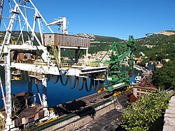
Bakar is a port for bulk cargo and used to be known for its industrial complex that included a coke factory, which produced a considerable amount of pollution. Bakar's coke factory was closed in 1995 and the area's pollution has subsided significantly. The historical core of Bakar was registered as a cultural monument in 1968. [5]

Municipality

Population of settlements in Bakar, 2011:
Bakar1,473
Hreljin 2,206
Krasica 1,353
Kukuljanovo 905
Plosna 44
Ponikve 45
Praputnjak 593
Škrljevo 1,344
Zlobin 316

Climate

Since records began in 1997, the highest temperature recorded at the local weather station was 39.0 °C (102.2 °F), on 19 July 2007. [6] The coldest temperature was −9.5 °C (14.9 °F), on 3 February 2012. [7]

Demographics

In 1895, the Bakar held the status of "city" (Croatian : grad), with an area of 3.3995 square kilometres (1.3126 sq mi), belonging directly to the županija of Modruš-Rijeka (Ogulin court and financial board). There were 408 houses, with a population of 1950. Its 3 villages hamlets were encompassed for taxation purposes by a single porezna obćina. The city had no statistical markets. [8] :vi,vii

In 1910, the court of Bakar encompassed an area of 143 square kilometres (55 sq mi), with a population of 12,929. Bakar had its own cadastral jurisdiction and business court. [9] :xxxii

Grad Bakar: Population trends 1857–2021
v
population
11497
10401
10022
9977
9804
9603
10137
8658
6953
7079
7788
8008
7469
7577
7773
8279
7573
18571869188018901900191019211931194819531961197119811991200120112021

Coat of arms

Bakar was granted its coat of arms and town privileges in 1799 by Francis II, Holy Roman Emperor. The coat of arms was in the artistic style typical for the period, with a cartouche with large landscapes and ornamentation around the shield within a circular inscription.

The shield of the coat of arms features a red-and-white checkered top or "chief", with three local gray stone castles on green hills in the middle, and a black anchor on orange at the bottom.

Recognizable buildings

Bakar Fort Bakar Croatia 2010 0728 05.JPG
Bakar Fort

History

Roads above the town Sv. Kuzam - tobogan - panoramio.jpg
Roads above the town
Port of Urinj INA Refinery in Bakar Port of INA Urinj Refinery in Bakar.jpg
Port of Urinj INA Refinery in Bakar

In 1607 and 1608, Nikola VI Zrinski complained to the Slavonian Sabor about certain violent acts committed by the soldiers of Senj in the Bay of Bakar, where they plundered and wrecked two ships loaded with oil and grain. [10] :485 [11] :515,516

In 1616, Venetian vessels had attempted to invade Bakar but was repelled by the local population with reinforcements from Rijeka

In July 1876, [12] a savings bank opened in Bakar. It competed with the savings bank in Kraljevica (established 1873), forcing it into bankruptcy in 1878. [13] :6

In the late 19th and early 20th century, Bakar was a district capital in the Modruš-Rijeka County of the Kingdom of Croatia-Slavonia.

World War I

In February 1918, during World War I, Gabriele D'Annunzio and Costanzo Ciano took part in a daring, if militarily irrelevant, naval raid on the harbour of Bakar (known in Italy as La beffa di Buccari, lit. "The Bakar mockery"), helping to raise the spirits of the Italian public.

After WWI, from the end of 1920, Bakar was one of the major points of entry of thousands of Russian refugees, arriving in the Kingdom of SHS following the end of the Russian Civil War in the European part of the former Russian Empire, mostly from Crimea, after the final defeat of White armies under general Wrangel there in November 1920.

Kingdom of Yugoslavia

In 1930, an HKD Napredak branch was founded in Bakar. [14]

World War II

During WW II, in Bakar was an Italian concentration camp, where civil population from Province of Ljubljana, [15] as well as Croats and Serbs was interned. It the peak, there was 893 internees. [16]

Recent

The last two days of November 2008, the maximum wave height at Bakar reached 117 centimetres (46 in) above the average sea level, higher than ever recorded since records began there in 1929. Little rain fell, but the city was flooded anyway thanks to a strong sirocco wind. Firefighters had to pump water from basements and the HEP had to repair broken power lines. [17]

Trivia

In 1972 director Radley Metzger filmed his movie Score in Bakar, Croatia.

References

  1. "Objava konačnih rezultata" (in Croatian). Retrieved 30 May 2017.[ permanent dead link ]
  2. Register of spatial units of the State Geodetic Administration of the Republic of Croatia. Wikidata   Q119585703.
  3. "Population by Age and Sex, by Settlements" (xlsx). Census of Population, Households and Dwellings in 2021. Zagreb: Croatian Bureau of Statistics. 2022.
  4. "Population by Age and Sex, by Settlements, 2011 Census: Bakar". Census of Population, Households and Dwellings 2011. Zagreb: Croatian Bureau of Statistics. December 2012.
  5. Černeka, Fabijan. "Naša mjesta". www.tz-bakar.hr (in Croatian). Retrieved 2023-04-30.
  6. DHMZ (2022-07-19). "Najviše izmjerene temperature zraka u Hrvatskoj za razdoblje od kada postoje mjerenja". Državni hidrometeorološki zavod.
  7. DHMZ (2022-01-21). "Najniže izmjerene temperature zraka u Hrvatskoj za razdoblje od kada postoje mjerenja". Državni hidrometeorološki zavod.
  8. Kraljevski zemaljski statistički ured (1895). "Glavni pregled područja županija, upravnih kotara i obćina, sudbenih stolova, sudbenih kotara, financijalnih ravnateljstva, poreznih ureda i izbornih kotara". Političko i sudbeno razdieljenje kralj. Hrvatske i Slavonije i Repertorij prebivališta po stanju od 31. svibnja 1895. Zagreb: Kraljevska hrvatsko-slavonsko-dalmatinska zemaljska vlada. pp. I–XXVII.
  9. Kraljevski zemaljski statistički ured (May 1913). "Sudbeno razdjeljenje Kraljevina Hrvatske i Slavonije". Političko i sudbeno razdjeljenje i Repertorij prebivališta Kraljevina Hrvatske i Slavonije po stanju od 1. siječnja 1913. Zagreb: Kraljevska hrvatsko-slavonsko-dalmatinska zemaljska vlada, 🖶 Kraljevska zemaljska tiskara. pp. XXXI–XXXIII.
  10. Šišić, Ferdo, ed. (1917-07-13) [written 1607-06-24]. "Articuli dominorum et nobilium aliorumque statuum et ordinum regni Sclavoniae, ex edicto magnifici domini Joannis Draskovich etc. bani in gnerali eorum congregatione in civitate regia Montisgraecensis Zagrabiensis celebrata, editi et conclusi". Hrvatski saborski spisi. Monumenta spectantia historiam Slavorum meridionalium (in Latin). Vol. XLI, IV. Zagreb. pp. 486–490.{{cite book}}: CS1 maint: location missing publisher (link)
  11. Šišić, Ferdo, ed. (1917-07-13) [written 1608-09-03]. "Articuli dominorum et nobilium aliorumque statuum et ordinum regni Sclavoniae, in generali ipsorum congregatione, comitatui Varasdiensi, vacante officio banatus per spectabilem et magnificum dominum comitem Thomam Erdeödy de Monyorokerek etc., comitibus vero Zagrabiensi et Crisiensi per generosum ac egregium Christophorum Merniavchich de Brezovicza vicebanum dicti regni Sclavonia ac eorundem comitatuum comitem indicta et publicata in arce Zagrabiensi, pro secunda et tertia diebus mensis septembris celebrata, anno domini millesimo sexcentesimo octavo". Hrvatski saborski spisi. Monumenta spectantia historiam Slavorum meridionalium (in Latin). Vol. XLI, IV. Zagreb. pp. 512–521.{{cite book}}: CS1 maint: location missing publisher (link)
  12. Zoričić, Milovan (1879) [written November 1878]. "Tvrdka, sjedište, početak poslovanja i dionička glavnica bankov. zavoda i štediona". Statistika vjeresijskih zavoda za godine 1847-1877 za godine 1847-1877. Zagreb: Kraljevski zemaljski statistički ured, 🖶 Dragutin Albrecht. pp. 2–3.
  13. Zoričić, Milovan (1879) [written November 1878]. "Bankovni zavodi i štedione". Statistika vjeresijskih zavoda za godine 1847-1877 za godine 1847-1877. Zagreb: Kraljevski zemaljski statistički ured, 🖶 Dragutin Albrecht. pp. 1–68.
  14. Matić 2004, p. 1185.
  15. Ivanka Zamida: a survivor's testimonial, from 2013 exhibition "The Last Witnesses", National Museum for Contemporary History, Ljubljana
  16. Bakar concentration camp, Online Research project
  17. V.R.T. (June 2009). "Olujno nevrijeme poharalo sjeverni Jadran" (PDF). Nazovi 193 (in Croatian). Vol. 2, no. 3. p. 16. Archived from the original (PDF) on 2022-09-27.

Bibliography

Dialectology

History