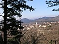
Hreljin administratively belongs to the city of Bakar, situated in Primorje-Gorski Kotar County - Primorsko-goranska županija.
The village includes the hamlets of Solnice (center of village), Pod Solnice, Biljin, Raskrizje, Stara cesta, Copovsko, Knezovo, Tursko, Vidasko, Sobolsko, Zastene, Gaj, Maj, Lonja, Glavicina, Dorisko, Placa, Kalac, Dragisino, Hrustica, Popelisce, Princica, Kalvarija, Cerkul, Fister, Melnice and Plase.
History
Legend claims that a Greek named Herkul founded the village.
In 1228 Hreljin signed the Vinodol act making Hreljin Castle one of nine Vinodol castles.
Hreljin was mentioned on 22 February 1481 in a document freeing the citizens of Grič from tariffs in Hreljin and elsewhere.[3]
In 1607 and 1608, Nikola VI Zrinski complained to the Slavonian Sabor about certain violent acts committed by the soldiers of Senj in the Bay of Bakar, where they plundered and wrecked two ships loaded with oil and grain.[4]:485[5]:515,516
On 25 March 2022 at 16:53 the ŽVOC Rijeka received a call about a wildfire in the area. 8 hectares (20 acres) burned by the time it was put out at 22:16 by JVP Rijeka, DVD Hreljin, DVD Zlobin, DVD Škrljevo and DVD Bakar.[6]
Demographics
In 1895, the obćina of Hreljin (court at Hreljin), with an area of 40.97 square kilometres (15.82sqmi), belonged to the kotar of Sušak (Bakar court and electoral district) in the županija of Modruš-Rieka (Ogulin court and financial board). There were 815 houses, with a population of 3587. Its 9 villages were divided for taxation purposes into 3 porezne obćine, under the Bakar office.[7]:iv,v
↑ Šišić, Ferdo, ed. (1917-07-13) [written 1607-06-24]. "Articuli dominorum et nobilium aliorumque statuum et ordinum regni Sclavoniae, ex edicto magnifici domini Joannis Draskovich etc. bani in gnerali eorum congregatione in civitate regia Montisgraecensis Zagrabiensis celebrata, editi et conclusi". Hrvatski saborski spisi. Monumenta spectantia historiam Slavorum meridionalium (in Latin). Vol.XLI, IV. Zagreb. pp.486–490.{{cite book}}: CS1 maint: location missing publisher (link)
↑ Šišić, Ferdo, ed. (1917-07-13) [written 1608-09-03]. "Articuli dominorum et nobilium aliorumque statuum et ordinum regni Sclavoniae, in generali ipsorum congregatione, comitatui Varasdiensi, vacante officio banatus per spectabilem et magnificum dominum comitem Thomam Erdeödy de Monyorokerek etc., comitibus vero Zagrabiensi et Crisiensi per generosum ac egregium Christophorum Merniavchich de Brezovicza vicebanum dicti regni Sclavonia ac eorundem comitatuum comitem indicta et publicata in arce Zagrabiensi, pro secunda et tertia diebus mensis septembris celebrata, anno domini millesimo sexcentesimo octavo". Hrvatski saborski spisi. Monumenta spectantia historiam Slavorum meridionalium (in Latin). Vol.XLI, IV. Zagreb. pp.512–521.{{cite book}}: CS1 maint: location missing publisher (link)
This page is based on this Wikipedia article Text is available under the CC BY-SA 4.0 license; additional terms may apply. Images, videos and audio are available under their respective licenses.