Brod Moravice was first mentioned in 1260. The rural municipality was founded in the 14th century.[3] Throughout history, it has also been known as Moravice, Gornje Moravice, Turanj and Brodske Moravice. The name was first recorded in one of Bela IV's documents in 1260. The first settlements appeared in Gorski kotar as early as the 10th or 11th centuries, due to the fact that routes to the coast passed through this area.[3]
During the 15th and 16th centuries, the municipality was the subject of numerous Turkish raids.
On 4 June 1657, as part of a delimitation between the possessions of the Zrinski family in Brod and those of the Frankapan family in Severin, a document was drawn up before a committee in Moravičke Drage consisting of baron Planker oberhautmann of Karlovac on behalf of Juraj IV Frankapan and Juraj Sili kapetan dvoranski and vicekapetan of Žumberak and Boltizar Babonosić prefect of Ozalj on behalf of Petar Zrinski. Those who gave testimony about the boundary were Martin Goljak (80), Matija Šnepergar (80), Mihajlo Šepec (80), Petar Butina (85), Petar Abramović (85), Lovro Crnković (85), Juraj Šnepergar (88), Juraj Podnar (90), Matija Goljak (90), Jakov Goršet (90), Jakov Butina (90) and Martin Blažević who claimed to be a centenarian and helped build the Turanj tower in Gornje Moravice when ordered by brothers Juraj and Nikola Zrinski.[4]:6
In 1860–1879, Matija Mažuranić wrote a 62 folio manuscript today titled Writings on the Building of Roads in Gorski Kotar and Lika (Croatian: Spisi o gradnji cesta u Gorskom Kotaru i Lici), today with signature HR-ZaNSKR 6424. A 21 folio manuscript dated 1872 titled Darstellung der Entstehung des Baues ... der Luisenstrasse together with a translation by I. Mikloušić is kept as HR-ZaNSKR 4572.[5]:223
The volunteer fire department DVD Brod Moravice was founded in 1912,[7] and is today part of the Požarno područje Gorski kotar IV. Its current commander is Goran Magdić.[8]
Kingdom of Yugoslavia
A 22 December 1939 decision as part of agrarian reforms by BanŠubašić to confiscate the local forest property of the Thurn and Taxis family, Kálmán Ghyczy and Nikola Petrović resulted in a legal dispute known as the Thurn and Taxis Affair, in part because of the relative status of the family and in part because of the proximity to the Italian border.[9][10]
WWII
On 3 July 1942, a freight train was derailed together with 5 cistern wagons either between Brod Moravice and Hrvatske Moravice or between Delnice and Brod Moravice.[11]
At 19:00 on 11 September, a group of around 1000 Partisans from the Primorje-Gorski Kotar Detachment[sr] attacked a guard stationed at the power plant consisting of 20 Domobrans of the 25th company of the 3rd Regiment of the Second Division[hr], capturing the plant and blowing it up with explosives, leaving Brod Moravice, Delnice and Skrad without electricity.[12]
At 18:30 on the 16th, the same group of Partisans attacked with machine gun and rifle fire the garrison in Brod Moravice, setting fire to 6 villagers' homes. Battles lasted until 5:30 the next day, on which the attack was repelled.[13]
Modern
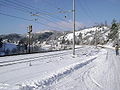
On 12 December 2017, a severe wind hit Brod Moravice, leaving it without electricity for several days and blocking traffic in the area.[14][15][16] This followed the ice storm and occurred during the Ips typographus epidemic in local forests.[17]
On 11 June 2019, hail up to 12 centimetres (4.7in)[18] in diameter fell in Brod Moravice.[19][18]
In 1895, the obćina of Brod Moravice (court at Brod Moravice), with an area of 47 square kilometres (18mi2), belonged to the kotar of Delnice (Delnice court and electoral district) in the županija of Modruš-Rieka (Ogulin court and financial board). There were 330 houses, with a population of 2297. Its 22 villages and 33 hamlets were divided for taxation purposes into 2 porezne obćine, under the Delnice office.[20]:iv,v
It is the smallest municipality by population, and the oldest one in its county.
The municipality is divided into 38 localities, included the town of Brod Moravice itself. In the 2011 census, there were a total of 985 inhabitants in the following settlements:[2][21]
On 1 July 1893, Skradobćina was divided into Skrad with tax districts Bukov Vrh and Divjake, and Brod-Moravice with tax districts Brod-Moravice and Završje.[24]:209
Sports
Beginning in 2013,[25] the 7 stage 260 kilometres (160mi) long Cycling Trail of Gorski Kotar (Croatian: Goranska biciklistička transverzala) passes through Brod Moravice.[26]
In 1913, there were three gendarmeries in Delnice kotar: one in Delnice itself, one in Brod Moravice and one in Fužine.[27]
Attractions
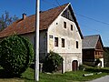
The municipality counts lot of ancient church buildings.[3] It is also a receptive place for tourism due to its natural environment.[28]
The 600 metres (2,000ft) long lindenavenue was planted at the beginning of the 20th century.[29]
↑Strohal, Rudolf (1932). Grad i selo Severin u Gorskom Kotaru na Kupi[The Town and Village of Severin in Gorski Kotar on the Kupa] (in Croatian). Zagreb: Jugoslovenska štampa.
Jurković, Viktor (1969). Brod-Moravice: 150-godišnjica osnovne škole, 1818 – 1968, 100-godišnjica školske zgrade, 1869 – 1969 (in Croatian). Brod Moravice: Osnovna škola Brod-Moravice.
This page is based on this Wikipedia article Text is available under the CC BY-SA 4.0 license; additional terms may apply. Images, videos and audio are available under their respective licenses.


.gif)