
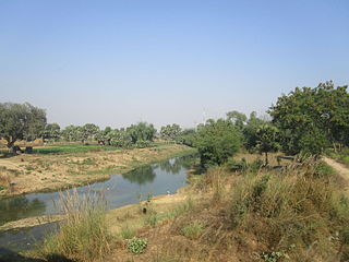
Son River is a perennial river located in central India. It originates near Amarkantak Hill in Gaurela-Pendra-Marwahi district of Chhattisgarh and finally merges with the Ganges River near Patna in Bihar. The Sone River is the second-largest southern tributary of the Ganges after the Yamuna River. India's oldest river bridge Koilwar Bridge over Sone River connects Arrah with Patna. Sone river is famous for its sand across country. Multiple dam(s) and hydro-electric projects run on its course towards Ganges.

The East Central Railway is one of the 19 railway zones in India. It is headquartered at Hajipur and comprises Sonpur, Samastipur, Danapur, Pt. Deen Dayal Upadhyaya, and Dhanbad divisions.

Arwal district is one of the thirty-eight districts of Bihar state, India, and Arwal town is the administrative headquarters of this district. It was earlier part of Jehanabad district.
Aurangabad district is one of the thirty-eight districts of Bihar state, India. It is currently a part of the Red Corridor.
Rohtas District is one of the thirty-eight districts of Bihar state, India. It came into existence when Shahabad District was bifurcated into Bhojpur & Rohtas in 1972. Administrative headquarter of the district is Sasaram. Rohtas district has the highest literacy in Bihar. The literacy rate of Rohtas district which is 73.37% as per 2011 census is highest among all 38 districts of Bihar.
Daudnagar is a town and the subdivisional headquarter of Daudnagar Subdivision in Aurangabad district in the state of Bihar, India under the Magadh division. Until 1991, there was only one Subdivision in the Aurangabad district: Aurangabad Sadar. On 31 March 1991, one other subdivision, Daudnagar, was created. Daudnagar is a 200-year-old historical city and its living proof is Daudnagar has an old historical fort situated on the eastern bank of the Son River. National Highway NH139 which connects Jharkhand's Palamu district to Patna, passes through the town.

Dehri also known as Dehri-on-Sone is a Nagar parishad and corresponding community development block in Rohtas district in the state of Bihar, India. Situated on the Son River, Dehri is a large industrial town and a railway hub.

Indrapuri Barrage is across the Son River in Rohtas district in the Indian state of Bihar.

Nasriganj is a nagar panchayat town and corresponding community development block situated in Rohtas District of Bihar, India. Located on the banks of the Son River, the town was a vibrant economic hub in the late 19th century. The town of Nasriganj had a population of 23,819, according to the 2011 Census of India, while the total population of Nasriganj block was 115,117. Besides the town of Nasriganj itself, the block consisted of 53 villages, of which 50 were inhabited and 3 were uninhabited.

Tilothu, also spelled Tilauthu or Tilothu, is a village and corresponding community development block in Rohtas district, Bihar, India. It is located 15 km from Dehri-on-Sone on the west bank of the Son River. As of 2011, the population of Tilouthu was 16,402, in 2,745 families, while the corresponding block population was 109,249.
Maudihan is a village in the Rohtas District of Bihar state, India. It is 14 km north of Dehri-On-Sone, an industrial city. It is located on Dehri-Patna road. It is also referred to as 'Maudiha'.
Arwal town is the administrative headquarters of Arwal district in Bihar state of India. It was earlier part of Jehanabad district. The district as formed to control the naxalism in the area. District was formed from the area of two near by districts i.e. Jehanabad and Aurangabad. Arwal has a population of 588,000. Arwal, the district headquarters is approximately 80 km south from the state capital Patna. Arwal town is situated on the right side bank of the Sone River, which is a tributary to the Ganges.

Nehru Setu is a railway bridge across the Son River, connecting Dehri-on-Son and Son Nagar, in Bihar.

Son Nagar Junction is a railway station in Aurangabad district it serves Barun, Daudnagar towns of Bihar. It is located on the east bank of the Son River and was earlier known as Son East Bank.

Dehri-on-Sone railway station is on the Gaya–Mughalsarai section of the Grand Chord line. It stands next to the Nehru Setu and serves Dehri and the surrounding areas in Rohtas district in the Indian state of Bihar. It's located on the banks of Son river, a tributary of river Ganges.

Dehri Rohtas Light Railway (DRLR) was a 2 ft 6 in narrow gauge railway line between Dehri-On-Sone and Tiura Pipara Dih in the state of Bihar, India.
The state of Bihar has a number of bridges, extending from few metres to a few kilometres. The history of long bridges goes back to the British Empire when the site for the Koilwar bridge was surveyed in 1851. Since then a number of small and large bridges have crept up. Some are even largest of their kind. Mahatma Gandhi Setu, joining Patna and Hajipur was India's longest river bridge from 1982 to 2017.
The Nabinagar Thermal Power Station Project (NTPS) of Bhartiya Rail Bijlee Company Limited is a wholly owned subsidiary of the Indian Railways, Ministry of Railways, Government of India. It installs a 4X 250 MW thermal power plant at Nabinagar in Aurangabad district, Bihar, India. Nearly 90 per cent of the electricity generated from the plant is supplied to the railways to meet nationwide requirements and remaining 10 per cent is given to Bihar.

National Highway 19 is a national highway in India. It was previously referred to as Delhi–Kolkata Road and is one of the busiest national highways in India. After renumbering of national highways, Delhi to Agra route is now national highway 44 and Agra to Kolkata route is numbered national highway 19. It constitutes a major portion of the historical Grand Trunk Road. It is also part of AH1 of Asian Highway Network, that traverses from Japan to Turkey.
Kajpa is a modern village situated in Aurangabad District of Bihar, India. It comes under village panchayat Kajpa. Kajpa is big Village in Aurangabad.

