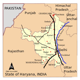
Haryana is an Indian state located in the northern part of the country. It was carved out after the linguistic reorganisation of Punjab on 1 November 1966. It is ranked 21st in terms of area, with less than 1.4% of India's land area. The state capital is Chandigarh, which it shares with the neighbouring state of Punjab; the most populous city is Faridabad, a part of the National Capital Region. The city of Gurgaon is among India's largest financial and technology hubs. Haryana has 6 administrative divisions, 22 districts, 72 sub-divisions, 93 revenue tehsils, 50 sub-tehsils, 140 community development blocks, 154 cities and towns, 7,356 villages, and 6,222 villages panchayats.

Panchkula district was formed as the 17th district of the Indian state of Haryana on 15 August 1995. It comprises two sub divisions and two tehsils: Panchkula and Kalka. It has 264 villages, out of which 12 are uninhabited and ten wholly merged with towns or treated as census towns according to the 1991 census. There are five towns in the district: Barwala, Kalka, Panchkula, Pinjore and Raipur Rani. The total population of the district is 319,398 out of which 173,557 are males and 145,841 are females.

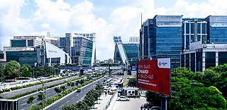
Panchkula is a city and district headquarter in the Panchkula district in Haryana, India. It is a satellite town of the state capital Chandigarh. Panchkula is a border city with Punjab, Chandigarh and Himachal Pradesh. The origin of the name Panchkula came from "the place where five irrigation canals meet". It is approximately 4 km (2.5 mi) southeast of Chandigarh, 105 km (65 mi) southwest of Shimla, 44 km (27 mi) from Ambala and 259 km (161 mi) northeast of New Delhi, the national capital. It is a part of the Chandigarh capital region or Greater Chandigarh. The Chandigarh-Mohali-Panchkula metropolitan region collectively forms a Chandigarh Tricity, with a combined population of over two million.
The administrative divisions of India are subnational administrative units of India; they are composed of a nested hierarchy of administrative divisions.
Dera Bassi is a satellite city of Chandigarh and a municipal council in Mohali district in the state of Punjab, India. Dera Bassi is located on the Chandigarh – Delhi National Highway, 8 km from Chandigarh. It is located within 20 km from Chandigarh, Mohali and Panchkula. It is strategically located near the boundary of Haryana, Punjab and Union territory of Chandigarh. Derabassi is most famous for its industrial belt, situated for the most part on Ramgarh and Barwala Road. The nearby sub town of Lalru was once a famous market for red chilli powder. The city and the nearby area host eight Engineering, B.Ed., Paramedical and Management institutes.
Pinjore is a town in Panchkula district in the Indian state of Haryana. This residential 'township', located close to Panchkula, Chandigarh, is set over 1,800 feet above the sea level in a valley, overlooking the Sivalik Hills. Pinjore is known for Pinjore Gardens, Asia's best 17th Century Mughal garden, and the Hindustan Machine Tools (HMT) factory.

Raipur Rani is a Town and Tehsil in Panchkula district in the Indian state of Haryana. It is one of three tehsils located in Panchkula District. It is located on the Panchkula city-Chandigarh-Nahan-Paonta Sahib-Dehradun highway 30 kilometres east from the Chandigarh-Mohali-Panchkula urban cities combine. It is about 20 kilometres from the Dera Bassi Industrial belt and 10 kilometres from the Barwala industrial estate. Narayangarh in the Ambala District is the next large town in its proximity.
Morni is a village and tourist attraction in the Morni Hills at the height of 1,267 metres (4,157 ft) in the Panchkula district of the Indian state of Haryana. It is located around 45 kilometres (28 mi) from Chandigarh, 35 kilometres (22 mi) from Panchkula city and is known for its Himalayan views, flora, and lakes. The name of Morni is believed to derive from a queen who once ruled the area two thousand years back. She was said to be a just and noble ruler. Morni was also a jagir of Raja Mir Syed Muhammad Baquar Ali Khan.

Chandigarh Capital Region (CCR) or Chandigarh Metropolitan Region (CMR) is an area, which includes the union territory city of Chandigarh, and its neighboring cities of Mohali, Kharar, Zirakpur, New Chandigarh (in Punjab) and Panchkula, Pinjore, Kalka, Barwala (in Haryana). Chandigarh Administration, Greater Mohali Area Development Authority (GMADA) and Haryana Urban Development Authority (HUDA) are different authorities responsible for development of this region. Baddi, an industrial town in nearby Himachal Pradesh, is also adjacent.

Mata Mansa Devi is a Hindu temple dedicated to goddess Mansa Devi, a form of Shakti, in the Panchkula district of the Indian state of Haryana. The temple complex is spread of 100 acres (0.40 km2) of the Shivalik foothills in the village of Bilaspur, near Sector 13 of Chandigarh, and Panchkula, 10 km from Chandi Mandir, another noted Devi shrine in the region, both just outside Chandigarh.

Ambala Division is one of the six divisions of Haryana State of India. The division comprises the districts of Ambala, Kurukshetra, Panchkula and Yamuna Nagar.
Haryana, formed on 1 November 1966, is a state in North India. For the administrative purpose, Haryana is divided into 6 revenue divisions which are further divided into 22 districts. For Law and Order maintenance, it is divided into 5 Police Ranges and 4 Police Commissionerates.
Chandigarh Metro is an approved rapid transit system to serve the Chandigarh Capital Region, which includes Chandigarh and adjacent areas in Punjab and Haryana states of India. In Phase-1, to be progressively built and operationalised between 2027 and 2034, 3 lines will connect tri-cities of Chandigarh, Mohali in Punjab and Panchkula in Haryana. Phase-2, to be constructed after 2034, will connect Pinjore in Haryana and further expand the network in Mohali with 2 more lines. The project, which was initially scrapped in 2017 due to low financial viability, was approved in March 2023 and received formal clearance in July 2024 from the governments of Punjab and Haryana after a Detailed Project Report (DPR) was created.

Barwala is a town situated 30 km northeast of Hisar city. It is one of the 4 sub-division of Hisar district in the state of Haryana, India.
Elections in Haryana, which is a state in India, have been conducted since 1967 to elect the members of state-level Haryana Legislative Assembly and national-level Lok Sabha. There are 90 assembly constituencies and 10 Lok Sabha constituencies.

The Pheasant Breeding Centre, Morni is a purpose-built centre for the breeding of pheasants situated in Panchkula district in Morni, a village and tourist attraction in the Morni Hills in the Panchkula district of the Indian state of Haryana. It is located around 45 kilometres (28 mi) from Chandigarh, 35 kilometres (22 mi) from Panchkula as its district and is known for its Himalayan views, flora, and lakes.
Barwala Assembly constituency is one of the 90 Vidhan Sabha constituencies of Haryana state in northern India.

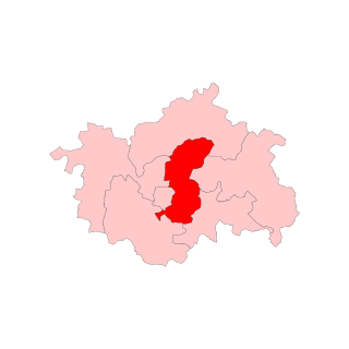
Panchkula Assembly constituency is one of the 90 assembly seats of Haryana in the Panchkula district of Haryana, India. It is under Ambala. It forms a part of a continuous area with the Union Territory of Chandigarh and the city of Mohali.

Gurugram Rajiv Gandhi Trust land grab case against Robert Vadra and Bhupinder Singh Hooda is being investigated by the Central Bureau of Investigation (CBI) as per Supreme Court of India's order. In the Gurugram Rajiv Gandhi Trust land grab scam between 2004 and 2014, then Government of Haryana administration of Indian National Congress's Chief Minister Bhupinder Singh Hooda, had handed over panchayat land to the Rajiv Gandhi Charitable Trust in the name of public interest use, resulting in this trust being sued by the gram panchayat in Punjab and Haryana High Court against the land grabbing of the Gandhi family by the Hooda government. Then Chief Minister Bhupinder Singh Hooda. who also held the charge of Panchayat department at that time, had approved the grant of 5.3 acre panchayat land to Rajiv Gandhi Trust for 33 years at a rate of Rs 3 lakh per acre in January 2010, trust applied for the change of land use on 3 December 2010, which was approved on the same day.


