Cape Split is a headland located on the Bay of Fundy coast of the Canadian province of Nova Scotia. The Battle off Cape Split happened during the American Revolution.

Caribou Tuya is a basaltic subglacial mound in far northwestern British Columbia that began eruptive activity under glacial ice during the Fraser glaciation. Like Ash Mountain and South Tuya, sections of the subglacial mound reveal a consistent stratigraphic progression from pillow lavas to hyaloclastite deposits from the base upward. Locally the sections are capped by subaerial basaltic lava flows. Samples of the glassy pillow basalts and hyaloclastites along with crystalline basalt flows were collected at Caribou Tuya. The volcano is believed to have formed and last erupted during the Pleistocene Epoch.
The Bridge River Cones, sometimes referred to as the Lillooet Cones and Salal Creek Cones, is the name given to a volcanic field located on the north flank of the upper Bridge River, about 40 km (25 mi) west of the town of Gold Bridge. The cones are in the lee of the Lillooet Icecap and sit astride a group of passes between the Bridge River, which flows W-E to their south, and the Lord River, which flows north to the Taseko Lakes in the Chilcotin District.
Ember Ridge is a volcanic mountain ridge associated with the Mount Cayley volcanic field in British Columbia, Canada. Ember Ridge is made of a series of steep-sided domes of glassy, complexly jointed, hornblende-phyric basalt with the most recent eruptions during the Holocene. The domes have structural similarities which indicate that the domes are similar in age and could have formed by the same foundation.
The Miles Canyon Basalts represent a package of rocks that include various exposures of basaltic lava flows and cones that erupted and flowed across an ancient pre-glacial landscape in south-central Yukon.
The Clisbako Caldera Complex is a large dissected caldera complex in the Chilcotin Group and Anahim Volcanic Belt in central British Columbia, Canada. It has a diameter of 60 km (37 mi) and is composed mainly of Eocene felsic and mafic volcanic rocks. Rocks within the caldera range in composition from basalt to rhyolite.
The Coldwell Complex is a large circular gabbro and syenite intrusion within the Earth's crust. Located on the North Shore of Lake Superior in northwestern Ontario, Canada, it is the largest alkaline intrusion in North America with a diameter of 25 km (16 mi).

The Fundy Basin is a sediment-filled rift basin on the Atlantic coast of southeastern Canada. It contains three sub-basins; the Fundy sub-basin, the Minas Basin and the Chignecto Basin. These arms meet at the Bay of Fundy, which is contained within the rift valley. From the Bay of Fundy, the Minas Basin trends northeast to Nova Scotia. Chignecto Bay runs from the Bay of Fundy northwest between New Brunswick and Nova Scotia which is separated from the waters of the Northumberland Strait by the Isthmus of Chignecto. The Fundy Basin is best known for the bay it contains. The Bay of Fundy is home to huge tidal changes and tidal bores. It is part of the system of Eastern North America Rift Basins.

The Fogo Seamounts, also called the Fogo Seamount chain, are a group of seamounts located about 500 km (311 mi) offshore of Newfoundland and southwest of the Grand Banks of Newfoundland. They consist of basaltic submarine volcanoes that formed during the Early Cretaceous period.

The Muskox intrusion is a layered intrusion in Nunavut, Canada. It is located 144 km (89 mi) northeast of Great Bear Lake and 90 km (56 mi) south of Kugluktuk on Coronation Gulf. It was formed during a large magmatic event during the Proterozoic by hotspot or mantle plume volcanism that emplaced the widespread Coppermine River Group flood basalts.

Cape Blomidon is a headland located on the Bay of Fundy coast of the Canadian province of Nova Scotia.

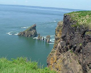
Isle Haute is an island in the upper regions of Bay of Fundy in Nova Scotia, near the entrance to the Minas Basin. It is 16 kilometers from the coast of Harbourville and eight kilometers south-southwest of Cape Chignecto. The island is part of Cumberland County, Nova Scotia and is three kilometres long and 400 metres wide. The Mi'kmaq used the island to make stone tools before Europeans arrived and called the island "Maskusetik", meaning place of wild potatoes.. In 1604, Samuel de Champlain gave the present name to the island, which means "High Island" in French, when he observed the towering bluffs, timber and fresh-water springs. The steep 100 m (328 ft) basalt cliffs of the island are the result from volcanic eruptions in the Jurassic period and may have been connected to the North Mountain volcanic ridge on the mainland 200 million years ago, before the Bay of Fundy was formed.
Rosebud Creek is a creek in eastcentral Yukon, Canada.
The Mess Lake Lava Field is a volcanic field associated with the Mount Edziza volcanic complex of the Northern Cordilleran Volcanic Province in northwestern British Columbia, Canada. It lies northwest of the Spectrum Range on the Kitsu Plateau and consists of young basaltic lava flows and tephra. The source for the basaltic lava and tephra was three cinder cones, including Mess Lake Cone and The Ash Pit, which may be the youngest volcanic feature of the Mount Edziza volcanic complex.
Mess Lake Cone is a cinder cone in northwestern British Columbia, Canada. It is polygenetic in nature, having erupted more than once throughout its eruptive history. Mess Lake Cone is one of the volcanoes that produced young basaltic lava flows in the central portion of the Mount Edziza volcanic complex in the past 10,000 years. These basaltic lava flows form a north-south trending volcanic field called the Mess Lake Lava Field.
Anderson Bay is a bay of Atlin Lake in northwestern British Columbia, Canada, located southwest of Pike Bay.
Walkout Creek Cone is a cinder cone in northwestern British Columbia, Canada. It is one of the volcanoes that produced young basaltic lava flows in the central portion of the Mount Edziza volcanic complex in the past 10,000 years. These basaltic lava flows form a volcanic field called the Snowshoe Lava Field.
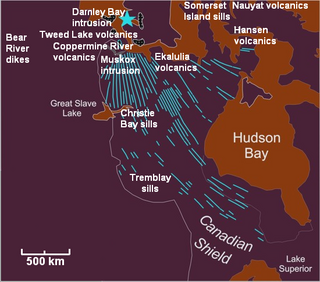
The Nauyat Formation is a Neoproterozoic-Mesoproterozoic geologic formation located on northwestern Baffin Island, Nunavut, Canada. It consists of a series of continental flood basalt lava flows of the Mackenzie Large Igneous Province with a thickness of at least 360 m (1,180 ft). These volcanic rocks range in age from 762 to 1,221 million years old.
The Ekalulia Formation is a Neoproterozoic geologic formation found in Nunavut, Canada. It consists of a series of massive continental flood basalt lava flows of the Mackenzie Large Igneous Province with a thickness of 300–500 m. The flood basalts are green, composed of olivine and contain minor pillows.
The Carmacks Group is a Late Cretaceous volcanic group in southwest-central Yukon, Canada, located between the communities of Dawson City and Whitehorse. It consists of flood basalts, coarse volcaniclastic rocks and sandy tuffs interbedded with subordinate andesite and basaltic lava flows. It has been interpreted to be a displaced portion of the Yellowstone hotspot track that was formed 70 million years ago.


