Bath Mountain

Last updated

Bath Mountain is a summit in Yosemite National Park, United States. [1] With an elevation of 10,482 feet (3,195 m), Bath Mountain is the 517th highest summit in the state of California. [2]

Yosemite National Park National park in California, United States

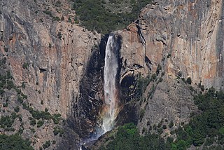
Yosemite National Park is an American national park located in the western Sierra Nevada of Central California, bounded on the southeast by Sierra National Forest and on the northwest by Stanislaus National Forest. The park is managed by the National Park Service and covers an area of 747,956 acres and sits in four counties: centered in Tuolumne and Mariposa, extending north and east to Mono and south to Madera County. Designated a World Heritage site in 1984, Yosemite is internationally recognized for its granite cliffs, waterfalls, clear streams, giant sequoia groves, lakes, mountains, meadows, glaciers, and biological diversity. Almost 95% of the park is designated wilderness.

United States federal republic in North America

The United States of America (USA), commonly known as the United States or America, is a country composed of 50 states, a federal district, five major self-governing territories, and various possessions. At 3.8 million square miles, the United States is the world's third or fourth largest country by total area and is slightly smaller than the entire continent of Europe's 3.9 million square miles. With a population of over 327 million people, the U.S. is the third most populous country. The capital is Washington, D.C., and the largest city by population is New York City. Forty-eight states and the capital's federal district are contiguous in North America between Canada and Mexico. The State of Alaska is in the northwest corner of North America, bordered by Canada to the east and across the Bering Strait from Russia to the west. The State of Hawaii is an archipelago in the mid-Pacific Ocean. The U.S. territories are scattered about the Pacific Ocean and the Caribbean Sea, stretching across nine official time zones. The extremely diverse geography, climate, and wildlife of the United States make it one of the world's 17 megadiverse countries.

Bath Mountain was so named when a USGS topographer took a bath in a lake at its base in 1905. [3]

United States Geological Survey scientific agency of the United States government

The United States Geological Survey is a scientific agency of the United States government. The scientists of the USGS study the landscape of the United States, its natural resources, and the natural hazards that threaten it. The organization has four major science disciplines, concerning biology, geography, geology, and hydrology. The USGS is a fact-finding research organization with no regulatory responsibility.

Related Research Articles

Bridalveil Fall waterfall in Yosemite

Bridalveil Fall is one of the most prominent waterfalls in the Yosemite Valley in California, Yosemite National Park. The waterfall is 188 metres (617 ft) in height and flows year round.

Clark Range (California)

The Clark Range is a subrange of California's Sierra Nevada in Yosemite National Park.

Hoover Wilderness

The Hoover Wilderness is a wilderness area in the Inyo and Humboldt-Toiyabe National Forests. It lies to the east of the crest of the central Sierra Nevada in California, to the north and east of Yosemite National Park - a long strip stretching nearly to Sonora Pass on the north and Tioga Pass on the south.

Bigelow Peak is a summit in Yosemite National Park, United States. With an elevation of 10,541 feet (3,213 m), Bigelow Peak is the 504th highest summit in the state of California.

Little Yosemite Valley

Little Yosemite Valley is a smaller glacial valley upstream in the Merced River drainage from the Yosemite Valley in Yosemite National Park. The Merced River meanders through the 3.5 mi (5.6 km) long flat valley, draining out over Nevada Fall and Vernal Fall before emptying into the main Yosemite Valley. It can be reached by a day hike from the main valley, and is the most popular area in the Yosemite Wilderness. The Valley provides access to nearby destinations such as the back side of Half Dome, Clouds Rest and the High Sierra Camp at Merced Lake.

Acker Peak is a summit in Yosemite National Park in California. With an elevation of 10,859 feet (3,310 m), Acker Peak is the 453rd highest summit in the state of California.

Ackerson Mountain is a summit in Tuolumne County, California, in the United States. With an elevation of 5,210 feet (1,590 m), Ackerson Mountain is the 2438th highest summit in the state of California.

Andrews Peak is a summit in Tuolumne County, California, in the United States. With an elevation of 8,537 feet (2,602 m), Andrews Peak is the 880th highest summit in the state of California.

Bartlett Peak is a summit in Yosemite National Park, California. With an elevation of 8,304 feet (2,531 m), Bartlett Peak is the 944th highest summit in the state of California.

Benson Lake is a lake in Yosemite National Park, United States.

Big Island Lake is a lake in Yosemite National Park, United States.

Boundary Lake is a lake in Tuolumne County, California, in the United States.

Branigan Lake is a lake in Yosemite National Park, California.

Mount Broderick is a summit in Yosemite National Park, United States. With an elevation of 6,696 feet (2,041 m), Mount Broderick is the 1573rd highest summit in the state of California.

Mount Bruce is a summit in Yosemite National Park, United States. With an elevation of 9,724 feet (2,964 m), Mount Bruce is the 626th highest summit in the state of California.

Bunnell Point is a summit in Mariposa County, California, in the United States. With an elevation of 8,172 feet (2,491 m), Bunnell Point is the 978th highest summit in the state of California.

Burro Pass, elevation 10,604 feet (3,232 m), is a mountain pass in Yosemite National Park, United States.

Camp Creek is a stream in Yosemite National Park, United States. It is a tributary of Piute Creek which is a tributary of the Tuolumne River. Camp Creek head waters start along the southside of Doghead Peak and head west.

Chittenden Peak is a summit in Yosemite National Park, United States. With an elevation of 9,580 feet (2,920 m), Chittenden Peak is the 649th highest summit in the state of California.

Colby Mountain is a summit in Tuolumne County, California, in the United States. With an elevation of 9,639 feet (2,938 m), Colby Mountain is the 644th highest summit in the state of California.

References

Coordinates: 38°03′29″N119°27′53″W / 38.0580°N 119.4647°W / 38.0580; -119.4647

Geographic coordinate system Coordinate system

A geographic coordinate system is a coordinate system that enables every location on Earth to be specified by a set of numbers, letters or symbols. The coordinates are often chosen such that one of the numbers represents a vertical position and two or three of the numbers represent a horizontal position; alternatively, a geographic position may be expressed in a combined three-dimensional Cartesian vector. A common choice of coordinates is latitude, longitude and elevation. To specify a location on a plane requires a map projection.