The Arctic Archipelago, also known as the Canadian Arctic Archipelago, is a group of islands north of the Canadian mainland.

Bertrab Glacier is a small glacier at the head of Gold Harbour, at the east end of South Georgia. It was charted by the Second German Antarctic Expedition, 1911–12, under Wilhelm Filchner, and named by him for General von Bertrab, Chief Quartermaster in the German General Staff and Chief of the Land Survey, who was chairman of the expedition.
Argentino Channel, also known as Ferguson Channel, is a channel between Bryde Island and the west coast of Graham Land, connecting Paradise Harbor with Gerlache Strait. It was first roughly charted by the Belgian Antarctic Expedition, 1897–99; the name "Canal Argentino" appears on an Argentine government chart of 1950.
Mount Banck is a conspicuous mountain of red rock, 675 m, dominating the small peninsula just west of Mascias Cove, on the west coast of Graham Land. In 1898 the Belgian Antarctic Expedition under Gerlache applied the name "Ile Banck" to a feature which was charted as an island separated from the mainland by a narrow channel. Air photos show it is actually a small peninsula, on which the most prominent feature is this mountain. The name Mount William, given by Biscoe in 1832 to a mountain which he described as being on the mainland but now identified on Anvers Island, has been used for the feature here described.
Boutan Rocks are a small group of rocks lying 1.5 miles (2.4 km) southwest of Bruce Island, off the west coast of Graham Land. The rocks appear on an Argentine government chart of 1954. They were named by the UK Antarctic Place-Names Committee in 1960 for Louis Marie-Auguste Boutan (1859–1934), French naturalist and pioneer of submarine photography, 1893–98.
Cetacea Rocks are a small group of rocks off the northeast side of Hoseason Island, in the Palmer Archipelago. They were charted by the French Antarctic Expedition under Jean-Baptiste Charcot, 1908–10, and named by the UK Antarctic Place-Names Committee in 1960 after the zoological order Cetacea ; these rocks lie in one of the chief Antarctic whaling areas.
Nottarp Glacier is a small glacier draining eastward into Lowery Glacier just south of Mount Damm in the Queen Elizabeth Range. Mapped by the United States Geological Survey (USGS) from tellurometer surveys and Navy air photos, 1960-62. Named by Advisory Committee on Antarctic Names (US-ACAN) for Klemens J. Nottarp, United States Antarctic Research Program (USARP) glaciologist on the Ross Ice Shelf, 1962–63 and 1965-66.
Perkins Glacier is a broad, low gradient glacier 8 nautical miles (15 km) south-southeast of Cape Burks on the coast of Marie Byrd Land. It drains west from McDonald Heights into the east side of Hull Bay. Mapped by United States Geological Survey (USGS) from surveys and U.S. Navy air photos, 1959-65. Named by Advisory Committee on Antarctic Names (US-ACAN) for Earle B. Perkins, biologist with the Byrd Antarctic Expedition, 1933-35.
The Glover Rocks are a group of rocks lying northwest of Avian Island, off the south end of Adelaide Island, Antarctica. They were named by the UK Antarctic Place-Names Committee for John F. Glover, 3rd Engineer of RRS John Biscoe (1962–63), the ship assisting the Royal Navy Hydrographic Survey Unit which charted the feature in 1963.
The Minerva Rocks are a small group of rocks lying off Chionis Island near Trinity Island, in the Palmer Archipelago, Antarctica. They were so named by whalers because the Minerva, one of the whale catchers of the British factory ship Pythia, went aground on these rocks in March 1922. The catcher was abandoned and, because of the heavy swell, became a total wreck.
Mascías Cove is a cove indenting the west coast of Graham Land, Antarctica, immediately east of Mount Banck. It was first roughly charted by the Belgian Antarctic Expedition under Gerlache, 1897–99, and later, by the Scottish geologist David Ferguson, 1913–14. It was named for Lieutenant Eladio Mascías of the tug Chiriguano which made a survey of the area during the Argentine Antarctic Expedition of 1949–50.
The Hydrurga Rocks are a group of rocks lying east of Two Hummock Island, in the Palmer Archipelago, Antarctica. They were photographed by the Falkland Islands and Dependencies Aerial Survey Expedition, 1955–57, and were named by the UK Antarctic Place-Names Committee in 1960 after Hydrurga leptonyx, the leopard seal.
Security Bay is a bay lying between Homeward and Gauthier Points on the north side of Doumer Island, in the Palmer Archipelago. First charted by the French Antarctic Expedition under Charcot, 1903-05. So named by the United Kingdom Antarctic Place-Names Committee (UK-APC) in 1958 because the bay gives adequate shelter to small craft against both the southwest gales which create a heavy sea in the southern entrance to Neumayer Channel and the strong northeasterly winds which funnel down the channel; it was used for this purpose several times by the British Naval Hydrographic Survey Unit in 1956-57.
Skeen Rocks is a two rocks lying south of Avian Island, off the south end of Adelaide Island. Named by the United Kingdom Antarctic Place-Names Committee (UK-APC) for Lieutenant Michael G.C. Skeen, Royal Navy, officer in charge of the helicopter flight, HMS charting this area in 1961-63.
Homeward Point is a point forming the west side of the entrance to Security Bay, on Doumer Island in the Palmer Archipelago, Antarctica. It was first charted by the French Antarctic Expedition, 1903–05, under Jean-Baptiste Charcot, and so named by the British Naval Hydrographic Survey Unit in 1956–57 because the point was sighted as a prominent landmark almost daily by the crew of their motor-launch when homeward bond for Port Lockroy at the end of a day's survey work in the Bismarck Strait.

Hooper Glacier is a glacier 3 nautical miles (6 km) long, flowing from the col north of Mount William into the west side of Börgen Bay, Anvers Island, in the Palmer Archipelago, Antarctica. It was surveyed by the Falkland Islands Dependencies Survey (FIDS) in 1955, and named by the UK Antarctic Place-Names Committee for Peter R. Hooper of FIDS, leader and geologist at the Arthur Harbour station in 1955 and 1956.
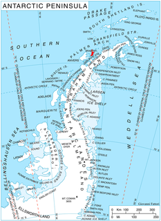
Rush Glacier is a glacier in Antarctica. Situated in southern Brabant Island, it is 4 nautical miles (7 km) long, draining the northwest slopes of Solvay Mountains and flowing west between Mount Aciar and Mount Sarnegor into the Buragara Cove of Dallmann Bay in the Palmer Archipelago. It was shown on an Argentine government chart in 1953, but not named. It was photographed by Hunting Aerosurveys Ltd in 1956-57, and mapped from these photos in 1959. The glacier was named by the United Kingdom Antarctic Place-Names Committee (UK-APC) for Benjamin Rush (1745–1813), a noted American physician and philanthropist, and a signatory of the Declaration of Independence.
Cape Lamb is a cape which forms the southwestern tip of Vega Island in the James Ross Island group, Antarctica. It was discovered by the Swedish Antarctic Expedition, 1901–04, under Otto Nordenskjold. It was resighted in 1945 by the Falkland Islands Dependencies Survey (FIDS), and named after Ivan M. Lamb (1911–90), a botanist on the FIDS staff at Port Lockroy (1944), Hope Bay (1945), and the leader of a biological expedition to the Melchior Islands, 1964–65.