Bay Bridge Troll

Last updated
Bay Bridge Troll. Cal-Trans Media Photo Bay Bridge troll1.JPG
Bay Bridge Troll. Cal-Trans Media Photo

The Bay Bridge Troll is an 18-inch steel figure that was welded to the eastern span of the original San Francisco Bay Bridge. It was replaced by a newer version in 2013 once the construction of the new Bay Bridge was complete. The creator of the original troll, Bill Roan, is a blacksmith turned artist who lived near the Bay Bridge.

Contents

History

In 1989, a section of the Bay Bridge collapsed during the Loma-Prieta earthquake that rocked the San Francisco Bay Area. The bridge was closed for several weeks while repairs were made. When the repairs to the bridge were nearly complete, ironworkers smuggled the small metal troll onto the bridge and welded it permanently to a steel beam on the north side of the bridge. This unusual topping out ceremony became the subject of much curiosity and rumor around the Bay Area. [1] John V. Robinson cites the Bay Bridge troll as an example of a custom being adapted to an unusual circumstance. [2]

The troll first came to the public's attention on January 15, 1990, when the San Francisco Chronicle ran a story about the small figure of a troll complete with a spud wrench that had been welded to the iron below the road on the north side of the bridge. [3] The article quotes official spokesman for the state Department of Transportation, Greg Bayol, as saying, "If we were asked, we would have said 'no,' I'm sure." The iron workers had never asked to put the troll on the bridge, so the state is stuck with the troll.

The troll was placed where motorists on the bridge would never see it. It was on the north side of the outside rail, where only maintenance workers and ironworkers ever venture. [3]

When the troll was made, the contractor, Rigging International, ordered another, now mounted on a damaged section of the old bridge on display in the lobby of their Alameda office. [4]

In August 2013, a white paper was published to the Bay Bridge's website, advocating the troll and the entire section of the span on which it resides be preserved. [5]

In 2002, a new eastern span of the Bay Bridge began construction. The new span opened on Labor Day 2013, and the troll was removed from the old span by ironworkers two days prior on August 30. The troll was on display at the Oakland Museum of California from November 6, 2013, through February 26, 2014. [6] During this time Caltrans considered whether to retire the troll to a museum or attach it to the tower of the new bridge. [7]

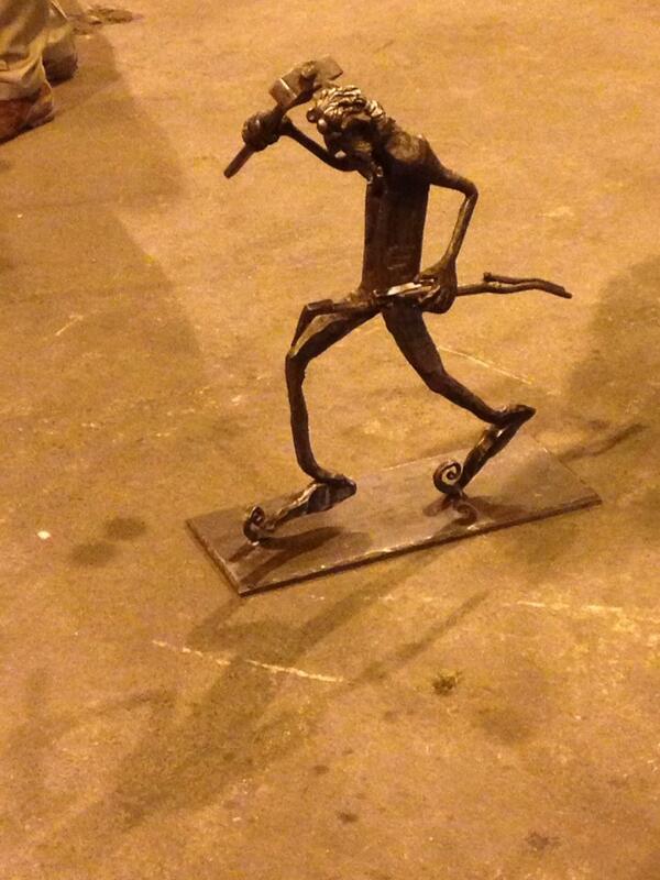
On December 23, 2013, an article in SFGate stated that a new, sleeker troll carrying a sledgehammer had been created. The article suggested that the new troll was either living temporarily in a secret location or was already installed on the new bridge.

On May 13, 2014, an article on SFGate Blog announced that the new troll has officially been placed on the eastern span of the Bay Bridge. It was said to have been installed overnight, as it is averse to sunlight. [8] "The new troll emerged from hiding Friday and quietly moved in, settling on Pier E2." The troll was placed below the roadway out of sight of motorists; however, it can be seen from a pedestrian walkway. [9] In March 2018 John V. Robinson published a book titled The Oakland-San Francisco Bay Bridge Troll which documents the creation and removal of the old troll as well as the creation of the new troll on the new Bay Bridge. [10]

See also

Related Research Articles

<span class="mw-page-title-main">Dumbarton Bridge (California)</span> Southernmost bridge crossing the San Francisco Bay

The Dumbarton Bridge is the southernmost of the highway bridges across San Francisco Bay in California. Carrying over 70,000 vehicles and about 118 pedestrian and bicycle crossings daily, it is the shortest bridge across San Francisco Bay at 1.63 miles. Its eastern end is in Fremont, near Newark in the San Francisco Bay National Wildlife Refuge, and its western end is in Menlo Park. Bridging State Route 84 across the bay, it has three lanes each way and a separated bike/pedestrian lane along its south side. Like the San Mateo Bridge to the north, power lines parallel the bridge.

<span class="mw-page-title-main">San Francisco–Oakland Bay Bridge</span> Complex of bridges spanning San Francisco Bay

The San Francisco–Oakland Bay Bridge, known locally as the Bay Bridge, is a complex of bridges spanning San Francisco Bay in California. As part of Interstate 80 and the direct road between San Francisco and Oakland, it carries about 260,000 vehicles a day on its two decks. It includes one of the longest bridge spans in the United States.

<span class="mw-page-title-main">Richmond–San Rafael Bridge</span> Bridge crossing the San Francisco Bay

The Richmond–San Rafael Bridge is the northernmost of the east–west crossings of California's San Francisco Bay, carrying Interstate 580 from Richmond on the east to San Rafael on the west. It opened in 1956, replacing ferry service by the Richmond–San Rafael Ferry Company, and was officially renamed in 1981 to honor California State Senator John F. McCarthy, who championed the bridge's creation.

<span class="mw-page-title-main">Caldecott Tunnel</span> Four-bore passage for CA SR 24 under the Berkeley Hills

The Caldecott Tunnel is an east–west highway tunnel through the Berkeley Hills between Oakland and Orinda, California. Its four bores carry California State Route 24. Named after Thomas E. Caldecott, former mayor of Berkeley, it opened in 1937 as a two-bore tunnel. The third bore opened in 1964 and the fourth bore in 2013. Currently, the two oldest bores carry eastbound traffic and the two newest bores carry westbound traffic.

<span class="mw-page-title-main">East Bay</span> Eastern region of the San Francisco Bay Area, California, US

<span class="mw-page-title-main">Carquinez Bridge</span> Pair of bridges in the San Francisco Bay between Crockett and Vallejo, California, USA

The Carquinez Bridge is a pair of parallel bridges spanning the Carquinez Strait at the northeastern end of San Francisco Bay. They form the part of Interstate 80 between Crockett and Vallejo, California, United States.

<span class="mw-page-title-main">Eastern span replacement of the San Francisco–Oakland Bay Bridge</span> Seismic stabilization megaproject in California (2002–2013)

The eastern span replacement of the San Francisco–Oakland Bay Bridge was a construction project to replace a seismically unsound portion of the Bay Bridge with a new self-anchored suspension bridge (SAS) and a pair of viaducts. The bridge is in the U.S. state of California and crosses the San Francisco Bay between Yerba Buena Island and Oakland. The span replacement took place between 2002 and 2013, and is the most expensive public works project in California history, with a final price tag of $6.5 billion, a 2,500% increase from the original estimate of $250 million, which was an initial estimate for a seismic retrofit of the span, not the full span replacement ultimately completed. Originally scheduled to open in 2007, several problems delayed the opening until September 2, 2013. With a width of 258.33 ft (78.74 m), comprising 10 general-purpose lanes, it is the world's widest bridge according to Guinness World Records.

<span class="mw-page-title-main">One Rincon Hill</span> Upscale residential complex on the apex of Rincon Hill in San Francisco

One Rincon Hill is an upscale residential complex on the apex of Rincon Hill in San Francisco, California, United States. The complex, designed by Solomon, Cordwell, Buenz and Associates and developed by Urban West Associates, consists of two skyscrapers that share a common townhouse podium. It is part of the San Francisco Skyline and is visible from Mt. Diablo, Port of Oakland and San Francisco.

<span class="mw-page-title-main">Oakland Estuary</span> Strait between Alameda Island and the mainland coast of California, United States

<span class="mw-page-title-main">Ferries of San Francisco Bay</span>

San Francisco Bay in California has been served by ferries of all types for over 150 years. John Reed established a sailboat ferry service in 1826. Although the construction of the Golden Gate Bridge and the San Francisco–Oakland Bay Bridge led to the decline in the importance of most ferries, some are still in use today for both commuters and tourists.

<span class="mw-page-title-main">Moore Dry Dock Company</span> Shipyard in Oakland, California, United States

<span class="mw-page-title-main">Blue & Gold Fleet</span>

Blue & Gold Fleet is a privately owned company in the United States providing ferry services in the San Francisco Bay Area of California. It operates the San Francisco Bay Ferry commuter ferry system under contract with WETA. Blue & Gold also operates tourist and excursion services under its own brand from Pier 41 in San Francisco, with midday ferry service to Sausalito and a variety of tourist routes. The company is the Bay Area's largest ferry transportation provider and carries approximately 4 million passengers annually.

<span class="mw-page-title-main">San Francisco Bay Ferry</span> Public transit passenger ferry service in the San Francisco Bay

San Francisco Bay Ferry is a public transit passenger ferry service in the San Francisco Bay, administered by the San Francisco Bay Area Water Emergency Transportation Authority (WETA). In 2022, the system had a ridership of 1,787,400, or about 9,400 per weekday as of the second quarter of 2023.

USS <i>Wenonah</i> (YT-148) Tugboat of the United States Navy

USS Wenonah (YT-148/YTB-148/YTM-148) was a Woban-class district harbor tug which served during World War II in California ports, and continued her service until she was struck by the Navy in 1974. On 17 August 2009, the Wenonah sank while berthed at Treasure Island, CA, and was raised by the floating crane Left Coast Lifter on 28 August 2009.

The Western Pacific Railroad (1862–1870) was formed in 1862 to build a railroad from Sacramento, California, to the San Francisco Bay, the westernmost portion of the First transcontinental railroad. After the completion of the railroad from Sacramento to Alameda Terminal on September 6, 1869, and then the Oakland Pier on November 8, 1869, which was the Pacific coast terminus of the transcontinental railroad, the Western Pacific Railroad was absorbed in 1870 into the Central Pacific Railroad.

<span class="mw-page-title-main">John V. Robinson</span> American writer and photojournalist (born 1960)

John V. Robinson is an American writer and photojournalist who specializes in photographing heavy construction work with a focus on bridge construction and the men and women who do the work. Robinson goes onto construction sites and does detailed photo essays of the iron workers, pile drivers, carpenters, laborers, and crane operators who do this demanding and dangerous work. He frequently collects oral histories of the workers.

<span class="mw-page-title-main">Yerba Buena Tunnel</span> Highway tunnel in San Francisco, California

The Yerba Buena Tunnel, also known as the Yerba Buena Island Tunnel, is a highway tunnel in San Francisco, California. It is the part of San Francisco–Oakland Bay Bridge complex that crosses Yerba Buena Island. The Yerba Buena Tunnel carries ten lanes of Interstate 80 (I-80) on two decks, connecting the two component spans of the Bay Bridge, the western suspension span and the eastern self-anchored suspension span. At the opening of the Bay Bridge in 1936, it was the world's largest-bore tunnel.

<span class="mw-page-title-main">San Mateo–Hayward Bridge</span> Road bridge across San Francisco Bay in California, United States

The San Mateo–Hayward Bridge is a bridge crossing the American state of California's San Francisco Bay, linking the San Francisco Peninsula with the East Bay. The bridge's western end is in Foster City, a suburb on the eastern edge of San Mateo. The eastern end of the bridge is in Hayward. It is the longest fixed-link bridge in California and the 25th longest in the world by length. The bridge is owned by the state of California, and is maintained by California Department of Transportation (Caltrans), the state highway agency. Further oversight is provided by the Bay Area Toll Authority (BATA).

<span class="mw-page-title-main">Southern Crossing (California)</span> Proposed fixed link across the San Francisco Bay

The Southern Crossing is a proposed highway structure that would span San Francisco Bay in California, somewhere south of the San Francisco–Oakland Bay Bridge and north of the San Mateo–Hayward Bridge. Several proposals have been made since 1947, varying in design and specific location, but none of them have ever been implemented because of cost, environmental and other concerns.

<i>The Bay Lights</i> American public art project

The Bay Lights were a site-specific monumental light sculpture and generative art installation on the western span of the San Francisco–Oakland Bay Bridge, designed to commemorate the 75th anniversary of its opening. The installation by light artist Leo Villareal included 25,000 individual white LEDs along 1.8 miles (2.9 km) of the cables on the north side of the suspension span of the bridge between Yerba Buena Island and San Francisco. The installation was controlled via a computer and displayed changing patterns that were not meant to repeat. The opening ceremony was held on March 5, 2013.

References

  1. John V. Robinson. Al Zampa and the Bay Area Bridges. San Francisco: Arcadia Publishing, 2005
  2. John V. Robinson. "The 'topping out' traditions of the high-steel iron workers." Archived 2015-09-24 at the Wayback Machine Western Folklore. Fall 2001.
  3. 1 2 Nolte, Carl. "Fantastic horned spirit Protects the Bay Bridge." San Francisco Chronicle January 15, 1990.
  4. Ellson, Michele (8 November 2013). "Bay Bridge troll has an Alameda twin". The Alamedan. Archived from the original on 15 March 2015. Retrieved 16 January 2015.{{cite news}}: CS1 maint: unfit URL (link)
  5. "For Whom the Troll Dwells" (PDF).
  6. "Bay Bridge Troll Comes to OMCA".
  7. "Lucky troll removed from Bay Bridge's old eastern span". Archived from the original on 2013-09-15. Retrieved 2020-06-28.
  8. Cabanatuan, Michael (26 December 2013). "Bay Bridge troll rumors fly – there's a new troll". SFGate. Retrieved 16 January 2015.
  9. Cabanatuan, Michael (13 May 2014). "New Bay Bridge troll finds home on eastern span". SFGate. Retrieved 16 January 2015.
  10. John V. Robinson. The Oakland-San Francisco Bay Bridge Troll. Fonthill Media, London.2018

37°48′52.6″N122°21′36.5″W / 37.814611°N 122.360139°W / 37.814611; -122.360139

Twin troll on display at Rigging International office in Alameda, California Twin of Bay Bridge Troll.jpg
Twin troll on display at Rigging International office in Alameda, California