
Bay Harbor is a ghost town in Bay County, Florida, United States.
Bay Harbor is a ghost town in Bay County, Florida, United States.
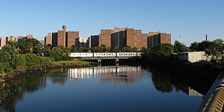
Bay Harbor was a small settlement mostly centered on the paper mill that was here at the site. Bay Harbor is currently part of the Panama City Paper Mill. [1]

Whitefish Township is a civil township of Chippewa County in the U.S. state of Michigan. The population was 575 at the 2010 census.

Peninsula Township, locally known as The Peninsula, is a civil township of Grand Traverse County in the U.S. state of Michigan. As of the 2010 census, the township population was 5,433, up from 5,265 at the 2000 census. The township is coterminous with the Old Mission Peninsula, which projects into the Grand Traverse Bay of Lake Michigan. The Old Mission Point Lighthouse is located at the northern end of the peninsula. The peninsula is included in the Old Mission Peninsula AVA, an American Viticultural Area known for its Michigan wine. The Grand Traverse region has two of Michigan's four federally recognized wine growing areas.
Coney Island Creek is a 1.8-mile-long (2.9 km) tidal inlet in Brooklyn, New York City. It used to be a 3-mile-long (4.8 km) continual strait and a partial mudflat connecting Gravesend Bay and Sheepshead Bay, making Coney Island an actual island, but the eastern half of the creek was filled in by land owners and city construction projects during a period spanning the early to mid 20th century.

The Penobscot River is a 109-mile-long (175 km) river in the U.S. state of Maine. Including the river's West Branch and South Branch increases the Penobscot's length to 264 miles (425 km), making it the second-longest river system in Maine and the longest entirely in the state. Its drainage basin contains 8,610 square miles (22,300 km2).
Port Madison, sometimes called Port Madison Bay, is a deep water bay located on the west shore of Puget Sound in western Washington. It is bounded on the north by Indianola, on the west by Suquamish, and on the south by Bainbridge Island. Port Madison connects to Bainbridge Island via the Agate Pass Bridge to the southwest. Two small bays open off Port Madison: Miller Bay to the northwest, and another small bay to the south which, confusingly, is also called Port Madison Bay.

Area code 269 is the telephone area code serving the southwest portion of Michigan's Lower Peninsula. Communities using 269 include Decatur, Dowagiac, Allegan, Battle Creek, Kalamazoo, Buchanan, Paw Paw, Portage, Otsego, Plainwell, St. Joseph, Benton Harbor, Marshall, Niles, Three Rivers, Sturgis, South Haven, Berrien Springs, and Bridgman.

231 is a North American telephone area code in the U.S. state of Michigan, serving the northwestern portion of the Lower Peninsula.
Vicksburg is a ghost town in Bay County, Florida, United States, located near the intersection of State Road 77 and County Road 388.

Powerview-Pine Falls is a town in the Canadian province of Manitoba, with a population of 1,314 at the 2011 census, up 1.54% from 1,294 at the 2006 census and down 7.57% from 1,400 during the 2001 census. The town is an amalgamation of the previous town of Powerview 50°33′58″N96°11′53″W with the previously unincorporated area of Pine Falls 50°33′59″N96°13′03″W, to its west. The town borders the Rural Municipality of Alexander and the Sagkeeng First Nation Indian reserve. The town was created as a paper mill town in the mid 1920s as Manitoba Pulp and Paper Company. The company was sold to Abitibi Paper Company and became Pine Falls Paper Group in 1995 after employee buyout and finally sold to Tembec in 1998. In 2009, Tembec shut down the mill for good and the site was demolished by 2012 but the mill's footprint next to Slasher Bay is still visible.

Ceresco is a small unincorporated community in Calhoun County in the U.S. state of Michigan. Ceresco is situated on the Kalamazoo River approximately five miles west of downtown Marshall. It is on the boundary between Marshall Township and Emmett Charter Township at 42°16′19″N85°03′41″W. Ceresco has a post office with ZIP Code 49033. The ZIP Code area serves portions of west and southwest Marshall Township, southeast Emmett Charter Township, northwest Fredonia Township, and a large portion of Newton Township.
Plymouth Harbor is a harbor located in Plymouth, a town in the South Shore region of the U.S. state of Massachusetts. It is part of the larger Plymouth Bay. Historically, Plymouth Harbor was the site of anchorage of the Mayflower where the Plymouth Colony pilgrims disembarked in 1620 to establish a permanent settlement at Plymouth.
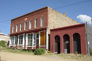
Nevadaville was a gold-mining town in Gilpin County, Colorado, United States. It was also known in the 1860s and 1870s as Nevada City. The post office at Nevadaville was called the Bald Mountain post office, to avoid confusion with other Nevadas and Nevadavilles. The community is now largely a ghost town, although not completely deserted. The Nevadaville Masonic Temple that started in 1861 still holds regular meetings.

Blue Hill is a town in Hancock County, Maine, United States. The population was 2,686 at the 2010 census. It is home to the Blue Hill Public Library, Blue Hill Memorial Hospital, George Stevens Academy, the Blue Hill Harbor School, The Bay School, New Surry Theatre, Kneisel Hall, Bagaduce Music Lending Library, the Kollegewidgwok Yacht Club, the Shaw Institute, and the Blue Hill Country Club. A community on Blue Hill Bay, the town is the site of the annual Blue Hill Fair.

Red Gap is southeast of Nanoose Bay on the east coast of southern Vancouver Island, British Columbia. The ghost town on BC Highway 19 is by road about 22 kilometres (14 mi) north of Nanaimo, and 16 kilometres (10 mi) south of Parksville.

Unga is a ghost town on Unga Island in the Aleutians East Borough of the U.S. state of Alaska, about two miles west of Sand Point. The island's length is 15 miles (24 km). Unga's altitude is 59 feet (18 m).

Andersonia is an unincorporated community in Mendocino County, California. It is located near U.S. Route 101 on the South Fork of the Eel River 1 mile (1.6 km) north-northwest of Piercy, at an elevation of 541 feet.

The Pequonnock River is a 16.7-mile-long (26.9 km) waterway in eastern Fairfield County, Connecticut. Its watershed is located in five communities, with the majority of it located within Monroe, Trumbull, and Bridgeport. The river has a penchant for flooding, particularly in spring since the removal of a retention dam in Trumbull in the 1950s. There seems to be a sharp difference of opinion among historians as to just what the Indian word Pequonnock signifies. Some insist it meant cleared field or open ground; others are sure it meant broken ground; while a third group is certain it meant place of slaughter or place of destruction.

Saints John, originally called Coleyville and later Saint John, is a former silver-mining town in Summit County, Colorado. About a mile from the town of Montezuma, Saints John was the site of one of the first silver discoveries in Colorado. Although no longer a town, it still has several inhabitants.
Cromanton is an unincorporated community in Bay County, in the U.S. state of Florida.

Taşucu Seka Harbor is a harbor in Turkey. Taşucu is a town in Silifke ilçe (district) of Mersin Province. It is situated to the west of the Göksu River and it is the main port of the settlements in the Göksu River valley. Taşucu is the name of the belde (town) and SEKA is the name of the paper mill situated next to Taşucu.
Municipalities and communities of Bay County, Florida, United States | ||
|---|---|---|
| Cities |  | |
| CDPs | ||
| Unincorporated communities | ||
| Ghost towns | ||
Coordinates: 30°08′31″N85°36′58″W / 30.142°N 85.616°W
| | This United States ghost town-related article is a stub. You can help Wikipedia by expanding it. |