
Santa Monica is a beachfront city in western Los Angeles County, California, United States. Situated on Santa Monica Bay, it is bordered on three sides by the city of Los Angeles – Pacific Palisades to the north, Brentwood on the northeast, West Los Angeles on the east, Mar Vista on the southeast, and Venice on the south. The Census Bureau population for Santa Monica in 2010 was 89,736.
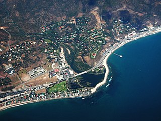
Malibu is a beach city in western Los Angeles County, California, situated about 30 miles (48 km) west of Downtown Los Angeles. It is known for its Mediterranean climate and its 21-mile (34 km) strip of the Malibu coast, incorporated in 1991 into the City of Malibu. The area is known for being the home of Hollywood movie stars, people in the entertainment industry, and other affluent residents. Most Malibu residents live within a few hundred yards of Pacific Coast Highway, which traverses the city, with some residents living up to a mile away from the beach up narrow canyons. As of the 2010 census, the city population was 12,645.

Muscle Beach refers to the exclusive Santa Monica location of the birthplace of the physical fitness boom in the United States during the 20th century, started in 1934 with predominantly gymnastics activities on the south side of the Santa Monica Pier. Muscle Beach Venice is the contemporary title of the outdoor weightlifting platform constructed in Venice, California, a distinct neighborhood in the city of Los Angeles, 18 years after Muscle Beach was established.

Santa Monica Bay is a bight of the Pacific Ocean in Southern California, United States. Its boundaries are slightly ambiguous, but it is generally considered to be the part of the Pacific within an imaginary line drawn between Point Dume, in Malibu, and the Palos Verdes Peninsula. Its eastern shore forms the western boundary of the Los Angeles Westside and South Bay regions. Although it was fed by the Los Angeles River prior to the river's catastrophic change of course in 1825, the only stream of any size now flowing into it is Ballona Creek. Other waterways draining into the bay include Malibu Creek, Topanga Creek, and Santa Monica Creek.

The Santa Monica Pier is a large double-jointed pier at the foot of Colorado Avenue in Santa Monica, California. With an iconic entrance, the pier is popular with residents and visitors as a landmark that is over 100 years old.
The history of Santa Monica, California, covers the significant events and movements in Santa Monica's past.

The Emerald Coast is an unofficial name for the coastal area in the US state of Florida on the Gulf of Mexico that stretches about 100 mi (161 km) through five counties, Escambia, Santa Rosa, Okaloosa, Walton, and Bay, from Pensacola to Panama City. Some south Alabama communities on the coast of Baldwin County, such as Gulf Shores, Orange Beach and Fort Morgan embrace the term as well. The coast was previously called the Miracle Strip. Informally the region has been dubbed the Redneck Riviera.

The Santa Monica Mountains National Recreation Area is a United States National Recreation Area containing many individual parks and open space preserves, located primarily in the Santa Monica Mountains of Southern California. The SMMNRA is located within the greater Los Angeles region, with two thirds of the parklands in northwest Los Angeles County, and the remaining third, including a Simi Hills extension, in southeastern Ventura County.

The Marvin Braude Bike Trail, also known as The Strand, is a paved bicycle path that runs mostly along the Pacific Ocean shoreline in Los Angeles County, California. The northern terminus of the trail is a paved Class 1 bicycle path at Will Rogers State Beach in Pacific Palisades, Los Angeles. The southern terminus of the trail is in Torrance County Beach in Torrance. The path is 22 miles long, and the midpoint between the two ends of the path is near the southern end of the Playa del Rey residential area.
Ocean Avenue is a road in Santa Monica, California that starts at the residential Adelaide Drive on the north end of Santa Monica and ends at Pico Boulevard. Ocean Avenue is the westernmost street in Santa Monica, and for most of its course it runs parallel to Palisades Park, whose bluffs overlook Pacific Coast Highway and Santa Monica State Beach.
The western border of Santa Monica, California is the 3-mile (4.8 km) stretch of Santa Monica Bay. On its other sides, the city is bordered by various districts of Los Angeles: the northwestern border is Pacific Palisades, the eastern border is Brentwood north of Wilshire Boulevard and West Los Angeles south of Wilshire, the northeastern border is generally San Vicente Boulevard up to the Riviera Country Club, the southwestern border is Venice Beach and the southern border is with West Los Angeles and Mar Vista.
Rustic Canyon is a residential neighborhood and canyon in eastern Pacific Palisades, on the west side of Los Angeles, California. It is along Rustic Creek, in the Santa Monica Mountains.

Santa Monica State Beach is a California State Park operated by the city of Santa Monica.
California's 26th State Senate district is one of 40 California State Senate districts. It is currently represented by Democrat Ben Allen of Santa Monica.
Sunnyside is an unincorporated community in Bay County, Florida, United States. It is part of the Panama City–Lynn Haven–Panama City Beach Metropolitan Statistical Area.
The Santa Monica Air Line was an interurban air-line railroad operated by the Pacific Electric between Santa Monica and downtown Los Angeles which ran from 1909 to 1953 and has been reactivated as the Expo Line.

Robert H. Meyer Memorial State Beach is a state beach of California, located in northern Malibu, Southern California.
The park is part of the Santa Monica Mountains National Recreation Area.

The California Incline is a slanted road in Santa Monica, California, connecting Ocean Avenue with State Route 1. It technically is the last link, the western end of California Avenue, a major east–west street in Santa Monica.


