Pretty Bayou, Florida

Last updated • 2 min readFrom Wikipedia, The Free Encyclopedia

Pretty Bayou, Florida
Interactive map outlining Pretty Bayou
Coordinates: 30°11′45″N85°41′48″W / 30.19583°N 85.69667°W / 30.19583; -85.69667
Country Flag of the United States.svg  United States
State Flag of Florida.svg  Florida
County Flag of Bay County, Florida.svg Bay
Area
[1]
  Total1.77 sq mi (4.58 km2)
  Land1.62 sq mi (4.19 km2)
  Water0.15 sq mi (0.40 km2)
Elevation
13 ft (4 m)
Population
 (2020)
  Total2,911
  Density1,800.25/sq mi (695.05/km2)
Time zone UTC-6 (Central (CST))
  Summer (DST) UTC-5 (CDT)
ZIP code
32405 [2]
Area code 850
FIPS code 12-58962 [3]
GNIS feature ID1867194 [4]

Pretty Bayou is a census-designated place (CDP) in Bay County, Florida, United States. The population was 2,911 at the 2020 census, down from 3,206 at the 2010 census. [5] It is part of the Panama City Panama City Beach, Florida Metropolitan Statistical Area. In 2018, Hurricane Michael caused significant damage to the city.

Contents

Geography

Pretty Bayou is located at 30°11′45″N85°41′48″W / 30.19583°N 85.69667°W / 30.19583; -85.69667 (30.195901, -85.696528). [6]

According to the United States Census Bureau, the Pretty Bayou CDP has a total area of 1.9 square miles (4.8 km2), of which 1.7 square miles (4.4 km2) is land and 0.15 square miles (0.4 km2), or 8.26%, is water. [7]

Demographics

Historical population
CensusPop.Note
1980 3,340
1990 3,83914.9%
2000 3,519−8.3%
2010 3,206−8.9%
2020 2,911−9.2%
source: [5] [8]

As of the census [3] of 2010, there were 3,206 people, 1,310 households, and 921 families residing in the CDP. The population density was 1,885.9 inhabitants per square mile (728.2/km2). There were 1,488 housing units at an average density of 875.3 per square mile (338.0/km2). The racial makeup of the CDP was 91.5% White, 3.1% African American, 0.4% American Indian or Alaska Native, 1.8% Asian, 0.8% some other race, and 2.2% from two or more races. Hispanic or Latino of any race were 3.3% of the population. [5]

There were 1,310 households, out of which 21.3% had children under the age of 18 living with them, 57.3% were headed by married couples living together, 8.7% had a female householder with no husband present, and 29.7% were non-families. 24.0% of all households were made up of individuals, and 10.6% were someone living alone who was 65 years of age or older. The average household size was 2.36, and the average family size was 2.77. [5]

In the CDP, the population was spread out, with 17.5% under the age of 18, 6.0% from 18 to 24, 19.5% from 25 to 44, 31.6% from 45 to 64, and 25.3% who were 65 years of age or older. The median age was 49.7 years. For every 100 females, there were 98.5 males. For every 100 females age 18 and over, there were 93.4 males. [5]

At the 2000 census, the median income for a household in the CDP was $48,347, and the median income for a family was $56,856. Males had a median income of $39,261 versus $29,185 for females. The per capita income for the CDP was $26,930. About 4.0% of families and 6.0% of the population were below the poverty line, including 5.5% of those under age 18 and 4.6% of those age 65 or over.

Related Research Articles

<span class="mw-page-title-main">Laguna Beach, Florida</span> Census-designated place in Florida, United States

Laguna Beach is a census-designated place (CDP) in Bay County, Florida, United States. The population was 4,330 at the 2020 census, up from 3,932 at the 2010 census. It is part of the Panama City–Panama City Beach, Florida Metropolitan Statistical Area. Laguna Beach was named for the many coastal dune lakes unique to this area of Northwest Florida.

Lower Grand Lagoon is a census-designated place (CDP) in Bay County, Florida, United States. The population was 4,398 at the 2020 census, up from 3,881 at the 2010 census. It is part of the Panama City–Panama City Beach, Florida Metropolitan Statistical Area.

Upper Grand Lagoon is a census-designated place (CDP) in Bay County, Florida, United States. The population was 15,778 at the 2020 census, up from 13,963 at the 2010 census. It is part of the Panama City–Panama City Beach, Florida Metropolitan Statistical Area.

<span class="mw-page-title-main">Pittman, Florida</span> Census-designated place in Florida

Pittman is an unincorporated community and census-designated place (CDP) in Lake County, Florida, United States. The population was 180 at the 2010 census. It is part of the Orlando–Kissimmee Metropolitan Statistical Area.

<span class="mw-page-title-main">Sorrento, Florida</span> Census-designated place in Florida

Sorrento is an unincorporated community and census-designated place in Lake County, Florida, United States. The population was 861 at the 2010 census, up from 765 at the 2000 census. It is part of the Orlando–Kissimmee Metropolitan Statistical Area.

<span class="mw-page-title-main">West Bradenton, Florida</span> Census-designated place in Florida, United States

West Bradenton is an unincorporated area and census-designated place (CDP) in Manatee County, Florida, United States. The population was 4,247 at the 2020 census, up from 4,192 at the 2010 census. It is part of the North Port–Bradenton–Sarasota, Florida Metropolitan Statistical Area.

<span class="mw-page-title-main">Coral Terrace, Florida</span> Census-designated place in Florida

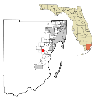
Coral Terrace is a suburban unincorporated community and census-designated place (CDP) in Miami-Dade County, Florida, United States. It is part of the Miami metropolitan area of South Florida. The population was 23,142 at the 2020 census, down from 24,376 in 2010.

<span class="mw-page-title-main">Homestead Base, Florida</span> Census-designated place in Florida

Homestead Base is a census-designated place (CDP) in Miami-Dade County, Florida, United States. The CDP comprises the extent of Homestead Air Reserve Base plus some surrounding land. It is part of the Miami metropolitan area of South Florida. The population was 999 at the 2020 census.

<span class="mw-page-title-main">Pinewood, Florida</span> Census-designated place in Florida

Pinewood is an unincorporated community and census-designated place (CDP) in Miami-Dade County, Florida, United States. It is part of the Miami metropolitan area of South Florida. The population was 17,246 at the 2020 census.

<span class="mw-page-title-main">The Crossings, Florida</span> CDP in Florida

The Crossings is a census-designated place (CDP) and suburb of Miami in Miami-Dade County, Florida, United States. It is part of the Miami metropolitan area of South Florida. The CDP includes the neighborhoods of The Crossings, Devon Aire, and Calusa. The population was 23,276 at the 2020 census.

<span class="mw-page-title-main">Three Lakes, Florida</span> Census-designated place in Florida

Three Lakes is a census-designated place (CDP) and planned community in Miami-Dade County, Florida, United States. It is part of the Miami metropolitan area of South Florida. The population was 16,540 at the 2020 census, up from 15,047 in 2010.

<span class="mw-page-title-main">Lake Sarasota, Florida</span> Census-designated place in Florida, United States

Lake Sarasota is a census-designated place (CDP) in Sarasota County, Florida, United States. The population was 3,979 at the 2020 census, down from 4,679 at the 2010 census. It is part of the North Port–Bradenton–Sarasota, Florida Metropolitan Statistical Area.

<span class="mw-page-title-main">Fern Park, Florida</span> Census-designated place & unincorporated community in Florida, United States

Fern Park is a census-designated place and a suburban unincorporated community in Seminole County, Florida, United States. The population was 8,318 at the 2000 census. It is part of the Orlando–Kissimmee Metropolitan Statistical Area.

Bayou Vista is a census-designated place (CDP) in St. Mary Parish, Louisiana, United States. The population was 4,652 at the 2010 census. It is part of the Morgan City Micropolitan Statistical Area.

<span class="mw-page-title-main">Escatawpa, Mississippi</span> Census-designated place in Mississippi, United States

Escatawpa is an unincorporated community and census-designated place (CDP) in Jackson County, Mississippi, United States. It is part of the Pascagoula Metropolitan Statistical Area. The population was 3,254 at the 2020 census.

<span class="mw-page-title-main">Spring Mount, Pennsylvania</span> Census-designated place in Pennsylvania, United States

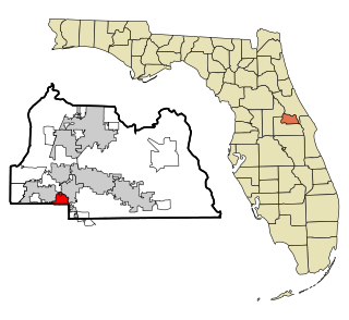
Spring Mount is a census-designated place (CDP) in Montgomery County, Pennsylvania, United States. The population was 2,259 at the 2010 census.

<span class="mw-page-title-main">Wolfdale, Pennsylvania</span> Census-designated place in Pennsylvania, United States

Wolfdale is a census-designated place (CDP) in Washington County, Pennsylvania, United States. The population was 2,888 at the 2010 census.

Tyler Run-Queens Gate was a census-designated place (CDP) in York County, Pennsylvania, United States. The population was 2,926 at the 2000 census. The area was redelineated as two separate CDPs, Tyler Run and Queens Gate, for the 2010 census.

<span class="mw-page-title-main">Valley Green, Pennsylvania</span> CDP in Pennsylvania, United States

Valley Green is a census-designated place (CDP) in York County, Pennsylvania, United States. The population was 3,429 at the 2010 census.

<span class="mw-page-title-main">Prosperity, West Virginia</span> Census-designated place in West Virginia, United States

Prosperity is a census-designated place (CDP) in Raleigh County, West Virginia, United States. The population was 1,498 at the 2010 census.

References

  1. "2020 U.S. Gazetteer Files". United States Census Bureau. Retrieved October 31, 2021.
  2. "Pretty Bayou FL ZIP Code". zipdatamaps.com. 2023. Retrieved February 17, 2023.
  3. 1 2 "U.S. Census website". United States Census Bureau . Retrieved January 31, 2008.
  4. "US Board on Geographic Names". United States Geological Survey. October 25, 2007. Retrieved January 31, 2008.
  5. 1 2 3 4 5 "Profile of General Population and Housing Characteristics: 2010 Demographic Profile Data (DP-1): Pretty Bayou CDP, Florida". United States Census Bureau . Retrieved March 15, 2012.
  6. "US Gazetteer files: 2010, 2000, and 1990". United States Census Bureau. February 12, 2011. Retrieved April 23, 2011.
  7. "Geographic Identifiers: 2010 Demographic Profile Data (G001): Pretty Bayou CDP, Florida". United States Census Bureau . Retrieved March 15, 2012.
  8. "CENSUS OF POPULATION AND HOUSING (1790-2000)". U.S. Census Bureau . Retrieved July 17, 2010.