The Longmenshan Fault is a thrust fault which runs along the base of the Longmen Mountains in Sichuan province in southwestern China. The strike of the fault plane is approximately NE. Motion on this fault is responsible for the uplift of the mountains relative to the lowlands of the Sichuan Basin to the east. Representing the eastern boundary of the Qinghai-Tibet Plateau, it is a border formation between the Bayan Kola block in the Plateau and the South China block in the Eurasian Plate. The 2008 Wenchuan, 2013 Lushan and 2022 Ya'an earthquakes occurred along this fault.
In seismology, a supershear earthquake is an earthquake in which the propagation of the rupture along the fault surface occurs at speeds in excess of the seismic shear wave (S-wave) velocity. This causes an effect analogous to a sonic boom.

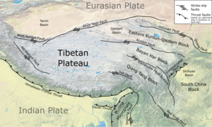
The Kunlun Fault is a major active left-lateral strike-slip fault to the north side of Tibet. Slippage along the 1,500-kilometre-long (930 mi) fault has occurred at a constant rate for the last 40,000 years. This has resulted in a cumulative offset of more than 400 metres (1,300 ft). The fault is seismically active, most recently causing the magnitude 7.8 2001 Kunlun earthquake. It forms the northeastern boundary of the elongate wedge of the Tibetan Plateau known as the Bayan Har block.
The 1927 Gulang earthquake occurred at 06:32 a.m. on 23 May. This 7.6 magnitude event had an epicenter near Gulang, Gansu in the Republic of China. There were 40,912 deaths. It was felt up to 700 km (435 mi) away.
The Altyn Tagh Fault (ATF) is a 2,000 km long, active, sinistral strike-slip fault that forms the northwestern boundary of the Tibetan Plateau with the Tarim Basin. It is one of the major sinistral strike-slip structures that together help to accommodate the eastward motion of this zone of thickened crust, relative to the Eurasian Plate. A total displacement of about ~475 km has been estimated for this fault zone since the middle Oligocene, although the amount of displacement, age of initiation and slip rate are disputed.
The 1879 Gansu earthquake occurred at about 04:00 local time on 1 July. It had an estimated magnitude of 8.0 on the scale and a maximum perceived intensity of XI (Extreme) on the Mercalli intensity scale. The epicenter was in Wudu District in southern Gansu, close to the border with Sichuan. It caused widespread damage and killed an estimated 22,000 people.
An earthquake occurred on 1 June 1786 in and around Kangding, in what is now China's Sichuan province. It had an estimated magnitude of about 7.75 and a maximum perceived intensity of X (Extreme) on the Mercalli intensity scale. The initial quake killed 435 people. After an aftershock ten days later, a further 100,000 died when a landslide dam collapsed across the Dadu river.
The Xianshuihe fault system or the Yushu-Ganzi-Xianshuihe fault system is a major active sinistral (left-lateral) strike-slip fault zone in southwestern China, at the eastern edge of the Tibetan Plateau. It has been responsible for many major earthquakes, and is one of the most seismically active fault zones in China.
The Haiyuan Fault is a major active intracontinental strike-slip (sinistral) fault in Central Asia.
The 2021 Maduo earthquake, also known as the 5.22 earthquake struck Madoi County in Qinghai Province, China on 22 May at 02:04 local time. The earthquake had a moment magnitude and surface-wave magnitude of 7.4. Highway bridges, roads and walls collapsed as a result of the earthquake. According to an anonymous source, at least 20 people were killed, 300 were injured, and 13 were missing. Officials stated that there were no deaths but 19 people sustained minor injuries. It was the strongest in China since 2008. It was assigned a maximum intensity of X in Machali, Maduo County on the China seismic intensity scale and Modified Mercalli intensity scale. This earthquake was preceded by another unrelated earthquake that occurred 5 hours earlier in Yunnan.
The 2020 Qiaojia earthquake occurred in Yunnan, China, 42 km west of Zhaotong on May 18, 21:48 local time. The moment magnitude 5.1 quake occurred at a depth of 10 km. Various buildings were damaged, and one house collapsed in Zhaoyang District. Four people were killed while 24 people were injured.
The 2021 Luxian earthquake was a damaging seismic event occurring in the early hours of September 16 at 04:33 China Standard Time. The surface wave magnitude (Ms ) 6.0 or moment magnitude (Mw ) 5.4 earthquake struck at a shallow depth of 7.5 km and severe shaking in an area of 4,000 square kilometers was assigned a maximum intensity of VIII on the China seismic intensity scale. Three people were killed and 146 injured when the earthquake struck Lu County, Luzhou, Sichuan Province. At least 36,800 buildings were affected, 7,800 of them seriously damaged or completely destroyed, causing about a quarter of a billion dollars worth of damage.
An earthquake occurred on June 19, 1718, in Tongwei County, Gansu Province, Qing dynasty, present-day China. The estimated surface wave magnitude (Ms ) 7.5 earthquake was designated a maximum Modified Mercalli intensity of X (Extreme), causing tremendous damage and killing 73,000 people.
The 1850 Xichang earthquake rocked Sichuan Province of Qing China on September 12. The earthquake which caused major damage in Xichang county had an estimated moment magnitude of 7.6–7.9 Mw and a surface wave magnitude of 7.5–7.7 Ms . An estimated 20,650 people died.
The 1654 Tianshui earthquake occurred on July 21 in Tianshui, Gansu Province, Ming dynasty sometime between 21:00 and 23:00 local time. The event had an estimated moment magnitude of 7.0 and was assigned a maximum intensity of XI on the China seismic intensity scale. Resulting in extreme damage and affecting at least four provinces, the quake killed approximately 30,000 people.
The 1923 Renda earthquake occurred on March 24 at 20:40 local time between the counties of Daofu and Luhuo in Sichuan, China. The estimated 7.3 earthquake was assigned a maximum modified Mercalli intensity scale rating of X (Extreme). Severe damage occurred in Sichuan, killing an estimated 4,800 people.
The 1955 Zheduotang earthquake, also known as the Kangding earthquake occurred on April 14 at 09:29:02 local time near the city of Kangding in the Garzê Tibetan Autonomous Prefecture, Sichuan. The earthquake had a moment magnitude of 7.0 and a surface wave magnitude of 7.1 and struck at a depth of 10 km. Severe damage occurred in Kangding with the loss of 70 lives.
On April 11, 1870, a moment magnitude 7.3 earthquake struck Batang County in Sichuan, China. The earthquake had a maximum Modified Mercalli intensity of X (Extreme). The earthquake and a large fire resulted in between 2,300 and 5,000 fatalities.
On 23 December 1738 the province of Qinghai was struck by an earthquake with an estimated magnitude of 7.6 . It ruptured the westernmost part of the Xianshuihe fault system, the Dangjiang segment. It led to 261–500 deaths.
The 1733 Dongchuan earthquake affected Yunnan in China on August 2. The earthquake, which had an estimated surface-wave magnitude of 7.75, damaged homes across the province.