Bayarban

Last updated
Bayarban
बयरबन
Kanepokhari sketch map.svg
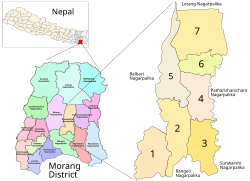
Kanepokhari in Morang District.
Bayarban VDC became Wards 3, 4, 6 and 7
Coordinates: 26°37′N87°31′E / 26.62°N 87.51°E / 26.62; 87.51
CountryFlag of Nepal.svg   Nepal
Zone Koshi Zone
District Morang District
Population
 (1991)
  Total
20,230
Time zone UTC+5:45 (Nepal Time)
Postal code
56606
Area code 021

Bayarban was a village development committee in the Morang District, Koshi Zone of south-eastern Nepal. It was named for the village of Bayarban Bazar. In 2017 it was absorbed by the newly created Kanepokhari Rural Municipality.

Contents

Location

Bayarban was in Nepal, Eastern Region, Kosī Zone, Morang. It had an elevation of about 107 metres (351 ft). [1] The Köppen climate classification is Cwa : Monsoon-influenced humid subtropical climate. [2]

Population

At the time of the 1991 Nepal census Bayarban had a population of 20,230. [3] The table below shows the populations in 2011 of the wards of Kanepokhari Rural Municipality. Bayarban became Wards 3, 4, 6 and 7 when Kanepokhari was constituted in March 2017. [4]

WardWard KendraHouseholds2011 PopulationMaleFemaleFormed from
1VDC Building Bayarban1121483022812549 Hoklabari all wards
2VDC Building1368594127583183 Keroun Wards 3, 4, 6-9
3Jayanepal Chowk1174523224492783Bayarban Wards 1-5
4Bayarban Bajar1174524223632879Bayarban Wards 6, 7
5 Bhousabari 1558677631073669 Keroun Wards 1, 2, 5
6VDC Building1340577126133158Bayarban Ward 8
7 Aitabare Bajar948424119162325Bayarban Ward 9

References

  1. "Bayarban", GeoNames, retrieved 2020-06-14
  2. "Bayarban, Morang, Kosī Zone, Purwanchal, Nepal", Mindat, retrieved 2020-06-14
  3. "Nepal Census 2001". Nepal's Village Development Committees. Digital Himalaya. Archived from the original on 12 October 2008. Retrieved 15 December 2008.
  4. Unit-9: Kanepokhari Gaunpalika (PDF), District Coordination Committee Office : Morang, Nepal, p. 10, archived from the original (PDF) on 2020-06-09, retrieved 2020-06-10