
Issaquena County is a county located in the U.S. state of Mississippi. As of the 2020 Census, its population was 1,338, making it the least populous county in the United States east of the Mississippi River. Its county seat is Mayersville. With a per-capita income of $18,598, Issaquena County is, by that measure, one of the poorest counties in the United States.

Bolivar County is a county located on the western border of the U.S. state of Mississippi. As of the 2020 census, the population was 30,985. Its county seats are Rosedale and Cleveland. The county is named in honor of Simón Bolívar, early 19th-century leader of the liberation of several South American territories from Spain.

Ascension Parish is a parish located in the U.S. state of Louisiana. As of the 2020 census, the population was 126,500. Its parish seat is Donaldsonville. The parish was created in 1807. Ascension Parish is part of the Baton Rouge metropolitan statistical area.
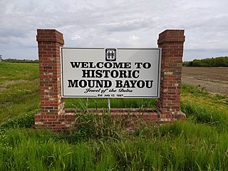
Mound Bayou is a city in Bolivar County, Mississippi, United States. The population was 1,533 at the 2010 census, down from 2,102 in 2000. It was founded as an independent black community in 1887 by former slaves led by Isaiah Montgomery. Mound Bayou Historic District is listed on the National Register of Historic Places.

Winstonville is a town in Bolivar County, Mississippi, United States. Per the 2020 census, the population was 153.

Kiln is an unincorporated community and census-designated place (CDP) in Hancock County, Mississippi, United States. The town is located about 50 miles (80 km) northeast of New Orleans, Louisiana. It is part of the Gulfport-Biloxi Metropolitan Statistical Area. The population was 2,238 at the 2010 census.

Des Allemands is an unincorporated community and census-designated place (CDP) in Lafourche and St. Charles parishes in the southeastern part of the U.S. state of Louisiana. The population was 2,179 at the 2020 census. The town, known as the "Catfish Capital of the Universe", is along the Bayou des Allemands, which is the boundary of Lafourche and St. Charles parishes. Lac des Allemands is located northwest of the town. The ZIP Code for Des Allemands is 70030.
Bayou Teche is a 125-mile-long (201 km) waterway in south central Louisiana in the United States. Bayou Teche was the Mississippi River's main course when it developed a delta about 2,800 to 4,500 years ago. Through a natural process known as deltaic switching, the river's deposits of silt and sediment cause the Mississippi to change its course every thousand years or so.

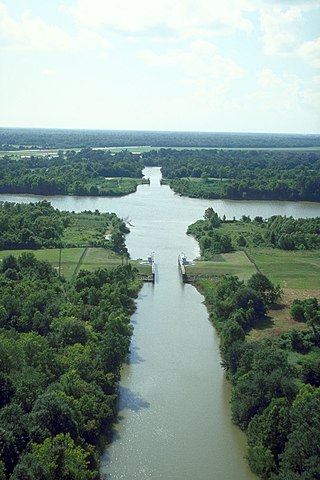
In usage in the Southern United States, a bayou is a body of water typically found in a flat, low-lying area. It may refer to an extremely slow-moving stream, river, marshy lake, wetland, or creek. They typically contain brackish water highly conducive to fish life and plankton. Bayous are commonly found in the Gulf Coast region of the southern United States, especially in the Mississippi River Delta, though they also exist elsewhere.

Bayou Lafourche, originally called Chetimachas River or La Fourche des Chetimaches,, is a 106-mile-long (171 km) bayou in southeastern Louisiana, United States, that flows into the Gulf of Mexico. The bayou is flanked by Louisiana Highway 1 on the west and Louisiana Highway 308 on the east, and is known as "the longest Main Street in the world." It flows through parts of Ascension, Assumption, and Lafourche parishes. Today, approximately 300,000 Louisiana residents drink water drawn from the bayou.

The Atchafalaya Basin, or Atchafalaya Swamp, is the largest wetland and swamp in the United States. Located in south central Louisiana, it is a combination of wetlands and river delta area where the Atchafalaya River and the Gulf of Mexico converge. The river stretches from near Simmesport in the north through parts of eight parishes to the Morgan City southern area.

The Gulfport–Biloxi Metropolitan Statistical Area is a metropolitan statistical area (MSA) in the Mississippi Gulf Coast region that includes four counties – Hancock, Harrison, Jackson and Stone. The principal cities are Gulfport and Biloxi. The 2010 census placed the Gulfport-Biloxi MSA population at 388,488, though as of 2019, it was estimated to have increased to 417,665. The area was significantly impacted by Hurricane Katrina on August 29, 2005, and prior to the hurricane, had experienced steady to moderate population growth. However, growth has since rebounded, with the population steadily increasing every year throughout the 2010s.

The Gulfport–Biloxi–Pascagoula Combined Statistical Area is made up of five counties in the Mississippi Gulf Coast region. The statistical area consists of the Gulfport–Biloxi Metropolitan Statistical Area and the Pascagoula Metropolitan Statistical Area. The 2010 census placed the CSA population at 411,066, and as of 2019, is estimated to be 442,165. The area was significantly impacted by Hurricane Katrina on August 29, 2005, although population growth has steadily rebounded in recent years.

The SS Nantucket was the last steam-powered ferry in regular operation on the East Coast of the United States. She was owned and operated by the Woods Hole, Martha's Vineyard and Nantucket Steamship Authority between 1957 and 1987.

Frenchmans Bayou is an unincorporated community in Mississippi County, Arkansas, United States. Frenchmans Bayou is located at the intersection of U.S. Route 61 and Arkansas Highway 308, 3.5 miles (5.6 km) southwest of Joiner. Frenchmans Bayou has a post office with ZIP code 72338.
DeLisle is a census-designated place (CDP) in Harrison County, Mississippi, United States. It is part of the Gulfport–Biloxi Metropolitan Statistical Area. The population was 1,147 at the 2010 census.

Mississippi Highway 606 is the unsigned designation for the 11.8-mile-long (19.0 km) Beach Boulevard in Hancock County, Mississippi. It travels entirely along the coastline of the Mississippi Sound, which is part of the Gulf of Mexico.
