Bayou Talla is a stream in Hancock County, Mississippi, United States, that is a tributary of the Jourdan River. [1]
Talla is a name derived from the Choctaw language meaning "palmetto". [2]

Pearl River County is a county located in the U.S. state of Mississippi. The population was 56,145 at the 2020 census. Its county seat is Poplarville. Pearl River County comprises the Picayune, MS Micropolitan Statistical Area, which is included in the New Orleans-Metairie-Hammond, LA-MS Combined Statistical Area. Pearl River County is a dry county, and as such, the sale, transportation, and even private possession of beverage alcohol is prohibited by law, except within Picayune and Poplarville.

Harrison County is a county located in the U.S. state of Mississippi. As of the 2020 census, the population was 208,621. Its county seats are Biloxi and Gulfport. The county is named after U.S. President William Henry Harrison. Harrison County is part of the Gulfport-Biloxi metropolitan area. The county was severely damaged from both Hurricane Camille on August 17, 1969, and Hurricane Katrina on August 29, 2005, causing catastrophic effects.

Hancock County is the southernmost county of the U.S. state of Mississippi and is named for Founding Father John Hancock. As of the 2020 census, the population was 46,053. Its county seat is Bay St. Louis. Hancock County is part of the Gulfport–Biloxi, MS Metropolitan Statistical Area. It is situated along the Gulf of Mexico and the state line with Louisiana. The area is home to the John C. Stennis Space Center, NASA's largest rocket engine test facility. The county was severely damaged from Hurricane Katrina on August 29, 2005, which caused a huge storm surge and catastrophic damage.

Kiln is an unincorporated community and census-designated place (CDP) in Hancock County, Mississippi, United States. The town is located about 50 miles (80 km) northeast of New Orleans, Louisiana. It is part of the Gulfport-Biloxi Metropolitan Statistical Area. The population was 2,238 at the 2010 census.

Cleveland is a city in Bolivar County, Mississippi, United States. The population was 11,199 as of the 2020 United States Census.

The Tallahatchie River is a river in Mississippi which flows 230 miles (370 km) from Tippah County, through Tallahatchie County, to Leflore County, where it joins the Yalobusha River to form the Yazoo River, which ultimately meets the Mississippi River at Vicksburg, Mississippi. The river is navigable for about 100 miles (160 km). At Money, Mississippi, the river's flow measures approximately 7,861 cubic feet (222.6 m3) per second.

Pearl River Community College is a public community college in Poplarville, Mississippi. It was founded as Pearl River County Agricultural High School in 1909 and became the first junior college in Mississippi in 1921.
Mississippi's 4th congressional district covers the southeastern region of the state. It includes all of Mississippi's Gulf Coast, stretching ninety miles between the Alabama border to the east and the Louisiana border to the west, and extends north into the Pine Belt region. It includes three of Mississippi's four most heavily populated cities: Gulfport, Biloxi, and Hattiesburg. Other major cities within the district include Bay St. Louis, Laurel, and Pascagoula. The district is currently represented by Republican Mike Ezell. With a Cook Partisan Voting Index rating of R+22, it is the most Republican district in Mississippi.

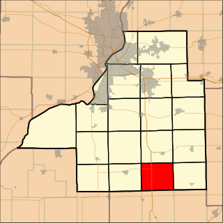
Boynton Township is located in Tazewell County, Illinois. As of the 2010 census, its population was 275 and it contained 94 housing units. Formed as Boyington Township in November, 1854, but the name was changed to Boynton on an unknown date.
Mississippi's 6th congressional district existed from 1873 to 1963. It was created after the United States 1870 census and abolished following the 1960 census, due to changes in population.
Floodwood River is an 11.0-mile-long (17.7 km) river in Ontonagon County in the U.S. state of Michigan.
DeLisle is a census-designated place (CDP) in Harrison County, Mississippi, United States. It is part of the Gulfport–Biloxi Metropolitan Statistical Area. The population was 1,147 at the 2010 census.
James Bayou Township is an inactive township in Mississippi County, in the U.S. state of Missouri.
St. James Township is an inactive township in Mississippi County, in the U.S. state of Missouri.
Mosquito Creek is a stream in the U.S. state of Wisconsin. It is a tributary to the Wisconsin River.
Catahoula Creek is a stream in the U.S. state of Mississippi. It rises in Pearl River County, flows through Hancock County for about 25 miles where it becomes the Jourdan River flowing into the Bay of St. Louis.
Bayou Talla may refer to:
Bayou Talla is a stream in Jackcon County, Mississippi, United States, that is a tributary of the Old Fort Bayou.
![]() Media related to Bayou Talla (Hancock County, Mississippi) at Wikimedia Commons 30°23′51″N89°25′33″W / 30.39750°N 89.42583°W
Media related to Bayou Talla (Hancock County, Mississippi) at Wikimedia Commons 30°23′51″N89°25′33″W / 30.39750°N 89.42583°W