
Redmond is a city in King County, Washington, United States, located 16 miles (26 km) east of Seattle. The population was 64,291 in a 2017 census estimate. Redmond is commonly recognized as the home of Microsoft and Nintendo of America. With an annual bike race on city streets and the state's only velodrome, Redmond is also known as the "Bicycle Capital of the Northwest".

Sammamish is a city in King County, Washington, United States. The population was 64,548 in a 2017 census estimate. Located on a plateau, the city is bordered by Lake Sammamish to the west and the Snoqualmie Valley to the east.

Lake Sammamish is a freshwater lake 8 miles (13 km) east of Seattle in King County, Washington, United States. The lake is 7 miles (11 km) long and 1.5 miles (2 km) wide, with a maximum depth of 105 feet (32 m) and a surface area of 8 sq mi (21 km2). It lies east of Lake Washington and west of the Sammamish Plateau, and stretches from Issaquah in the south to Redmond in the north. At Issaquah it is fed by Issaquah Creek, and at Redmond it drains to Lake Washington via the Sammamish River.
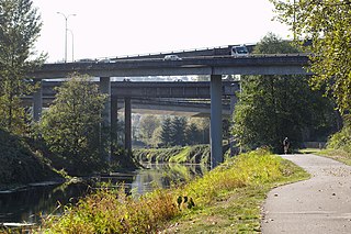
State Route 520 (SR 520) is a state highway and freeway in the Seattle metropolitan area, part of the U.S. state of Washington. It runs 13 miles (21 km) from Seattle in the west to Redmond in the east. The freeway connects Seattle to the Eastside region of King County via the Evergreen Point Floating Bridge on Lake Washington. SR 520 intersects several state highways, including Interstate 5 (I-5) in Seattle, I-405 in Bellevue, and SR 202 in Redmond.
The Burke-Gilman Trail is a rail trail in King County, Washington. The 27-mile (43 km) multi-use recreational trail is part of the King County Regional Trail System and occupies an abandoned Seattle, Lake Shore and Eastern Railway corridor.
Bear Creek or Bearcreek may refer to:
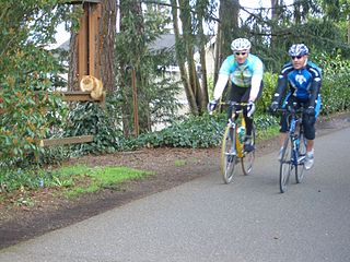
The Sammamish River Trail is a 10.9-mile (17.5 km) bike path and recreational trail in King County, Washington that runs along the Sammamish River from Blythe Park in Bothell to Marymoor Park in Redmond. It connects to the Burke-Gilman Trail at its north western end, and to the Redmond Central Connector at its south eastern end.

The East Lake Sammamish Trail is an 11-mile (18 km) recreational rail trail in King County, Washington that runs along Lake Sammamish from Marymoor Park in Redmond, through Sammamish, to Gilman Boulevard in Issaquah.

Klahanie is a planned community in Sammamish, Washington, United States. The population was 10,674 at the 2010 census. Prior to its annexation by the city of Sammamish in 2016, Klahanie was a census-designated place (CDP) in unincorporated King County.
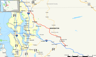
State Route 202 (SR 202) is a state highway in the U.S. state of Washington, serving part of the Seattle metropolitan area. It runs southeasterly for 31 miles (50 km) in the Eastside region of King County, serving the cities of Woodinville, Redmond, Fall City, and North Bend. The highway begins at SR 522 in Woodinville, intersects SR 520 in Redmond and SR 203 in Fall City, and terminates at Interstate 90 (I-90) in North Bend. The entire highway is designated as the Cascade Valleys Scenic Byway, a state scenic and recreational highway.
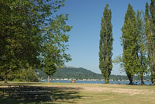
Lake Sammamish State Park is a park at the south end of Lake Sammamish, in King County, Washington, United States. The park is administered by the Washington State Park System. The park covers an area of 512 acres (0.80 sq mi) and has 6,858 feet (2,090 m) of waterfront and is known for its boating and watersport activities, such as waterskiing. The park has about 250 parking stalls for vehicle/trailer combinations. Issaquah Creek enters Lake Sammamish in the park.

Issaquah Creek is a small stream flowing through the city of Issaquah and nearby communities, in the U.S. state of Washington. Its headwaters are on the slopes of Cougar, Squak, Tiger, and Taylor mountains in the Issaquah Alps. Tributaries of Issaquah Creek include Holder Creek, Carey Creek, Fifteen-mile Creek, McDonald Creek, East Fork Issaquah Creek, and North Fork Issaquah Creek. The creek empties into the south end of Lake Sammamish. The lake's outlet is the Sammamish River, which in turn empties into Lake Washington and ultimately Puget Sound.

Marymoor Park, located on the north end of Lake Sammamish in Redmond, Washington, is King County's largest, oldest, and most popular park, with more than 3 million annual visitors coming to roam its 640 acres (2.6 km2). Among recreational activities available are various sports facilities, rock climbing, a 40-acre off-leash dog park and a velodrome. It is also one end of the Sammamish River Trail, a biking and walking trail. In addition, a radio control aircraft flying field and a pet memorial garden are within the park's boundaries.

Swamp Creek is a tributary of the Sammamish River in Snohomish and King Counties, Washington in the United States.

The Rice Fork is a 22.7-mile-long (36.5 km) tributary of the Eel River in Lake County, California. The Rice Fork begins on the upper northwest side of Goat Mountain, on the Colusa-Lake County line, at an elevation of over 6,000 feet (1,800 m). It quickly descends the steep western slope of the mountain, then bends northward, and flows northwesterly down a narrow winding steep walled canyon for about 18 miles (29 km), crossing two forest roads and adding many tributaries, ending its journey at the southern tip of Lake Pillsbury, at a varied elevation around 1,800 feet (550 m), depending on the lake level. Before the construction of Scott Dam in the 1920s, which formed Lake Pillsbury, the Rice Fork ran directly into the Eel River. It is one of Lake County's longest streams.
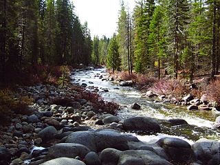
Dinkey Creek is a large stream in the southern Sierra Nevada, in Fresno County, California. The creek is 29.2 miles (47.0 km) long, flowing in a southerly direction through the Sierra National Forest. It is a tributary of the North Fork Kings River, in turn part of the Kings River system which drains to Tulare Lake.


