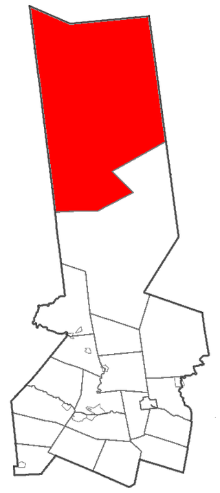
Webb is the northernmost town in Herkimer County, New York, United States. As of the 2010 census it had a population of 1,807.

Walton is a town in Delaware County, New York, United States. The population was 5,270 at the 2020 census. The town is in the west-central part of the county and contains the village of Walton. The town claims to be the "Scarecrow Capital of the World."
At 47,527 acres (192.33 km2), Harriman State Park is the second largest state park in the U.S. state of New York. Located in Rockland and Orange counties 30 miles (48 km) north of New York City, it is a haven for hikers with over 200 miles (320 km) of hiking trails. The park is also known for its 31 lakes, multiple streams, public camping area, and great vistas. The park's hiking trails are currently maintained by volunteers from the New York - New Jersey Trail Conference.

The Saint Regis Canoe Area in Adirondack Park is the largest wilderness canoe area in the Northeastern United States and the only designated canoe area in New York state. It is closed to motorized vehicles. Among the 50 ponds and lakes are Upper Saint Regis Lake, part of the Seven Carries route, and Saint Regis Pond. It contains the headwaters of the West and Middle Branch of the Saint Regis and the Saranac Rivers. Only two of the lakes can be reached without a portage, or carry as it is known in the region. Primitive canoe camping is permitted on many of the lakes and ponds. Saint Regis Mountain and Long Pond Mountain are within the area.

The cinnamon bear is both a highly variable color morph and a subspecies of the American black bear, native to the United States and Canada.

Popolopen is the name of several related landmarks mainly within the Hudson Highlands of Orange County, New York. These include a peak, Popolopen Torne—or simply "The Torne", and a short and steep-sided nearby valley officially called Hell Hole, but often Popolopen Gorge. Popolopen Creek runs through this valley. The Popolopen Bridge spans its mouth at the Hudson River and is crossed by Route 9W. Popolopen Lake feeds the headwaters of its namesake creek. Despite local usage, the United States Board on Geographical Names recognizes only the lake, creek and bridge as bearing the name "Popolopen."

Seneca Waterways Council (SWC) is a local council of the Boy Scouts of America that serves youth in Ontario, Wayne, Seneca, Yates, and Monroe Counties in Western New York. The current Council President is Ted Orr. The current Council Scout Executive is Stephen Hoitt.

Northeastern Pennsylvania Council, with headquarters in Moosic, Pennsylvania, formed in 1990 from the merger of Forest Lakes Council and Penn Mountains Council of the Boy Scouts of America. It covers the metropolitan area of Scranton and Wilkes-Barre, Pennsylvania. The council serves Lackawanna, Luzerne, Pike, Wayne, Wyoming counties, and portions of Susquehanna county.

The Golden Spread Council is a local council of the Boy Scouts of America and serves youth in the panhandles of Texas and Oklahoma. Its service area includes all or part of 23 counties in Texas and three counties in Oklahoma. Through 2010, the council served approximately 5,300 youth members and 1,700 adult leaders.

Sunfish Pond is a 44-acre (18 ha) glacial lake surrounded by a 258-acre (104 ha) hardwood forest located on the Kittatinny Ridge within Worthington State Forest, adjacent to the Delaware Water Gap National Recreation Area in Warren County, New Jersey. The Appalachian Trail runs alongside the western and northern edges of the lake. It was created by the Wisconsin Glacier during the last ice age. The lake was declared a National Natural Landmark in January 1970.
The Bay-Lakes Council is the Boy Scouts of America (BSA) council serving eastern Wisconsin and the Upper Peninsula of Michigan. Headquartered in Appleton, Wisconsin, it is geographically one of the largest local BSA councils. Bay-Lakes Council #635 was formed on July 1, 1973, the product of a merger between six east Wisconsin councils. The council is served by Kon Wapos Lodge of the Order of the Arrow.

Bear Lake Township is a civil township of Kalkaska County in the U.S. state of Michigan. As of the 2020 census, the township population was 668.

Brown Tract Pond Campground is a campground run by the New York State Department of Environmental Conservation in Raquette Lake, New York. It is located on the shores of Browns Tract Pond in a remote area of the Adirondacks, approximately two miles (3.2 km) from Raquette Lake, near the town of Inlet in Hamilton County.

Fossil Lake is a dry lakebed in the remote high desert country of northern Lake County in the U.S. state of Oregon. During the Pleistocene epoch, Fossil Lake and the surrounding basin were covered by an ancient lake. Numerous animals used the lake's resources. Over time, the remains of many of these animals became fossilized in the lake sediments. As a result, Fossil Lake has been an important site for fossil collection and scientific study for well over a century. Over the years, paleontologists have found the fossil remains of numerous mammals as well as bird and fish species there. Some of these fossils are 2 million years old.
Cedar Lake is located northwest of Sled Harbor, New York. Fish species present in the lake are brook trout, black bullhead, and white sucker. There is trail access on the north and west shores from Sled Harbor. There is also trail access to Whitney Lake. No motors are allowed on this lake.
Bear Pond is a small lake north-northeast of the hamlet of Moshier Falls in Herkimer County, New York. It drains south via an unnamed creek that flows into Beaver Lake.
Bear Pond is a lake located northeast of Stillwater, New York. The outflow creek flows into Middle Branch Oswegatchie River. Fish species present in the lake are brown bullhead, and brook trout. Access via trail off Raven Lake Road on the south shore. No motors are allowed on Bear Pond.


