Downsville, New York

Last updated
Downsville, New York
USA New York location map.svg
Red pog.svg
Downsville
Coordinates: 42°4′51″N74°59′44″W / 42.08083°N 74.99556°W / 42.08083; -74.99556 Coordinates: 42°4′51″N74°59′44″W / 42.08083°N 74.99556°W / 42.08083; -74.99556 [1]
CountryUnited States
State New York
County Delaware
Town Colchester
Area
[2]
  Total4.47 sq mi (11.58 km2)
  Land4.39 sq mi (11.38 km2)
  Water0.08 sq mi (0.21 km2)
Elevation
1,125 ft (343 m)
Population
 (2020)
  Total474
  Density107.92/sq mi (41.67/km2)
Time zone UTC-5 (Eastern (EST))
  Summer (DST) UTC-4 (EDT)
ZIP code
13755
Area code Area code 607
FIPS code [3] 36-20852
GNIS feature ID [1] 948622

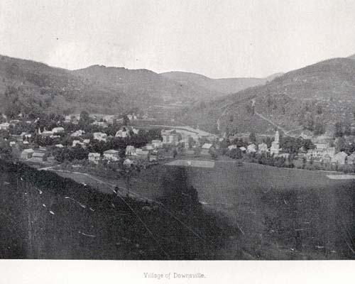
Downsville is a hamlet, census-designated place (CDP), and former village in the town of Colchester, Delaware County, New York, United States. [4] The population was 617 at the 2010 census. [3]

Contents

History

It is the site of the Downsville Bridge, a covered bridge, and the historic Union Free School. Both are listed on the National Register of Historic Places. [5]

Downsville is named for Abel Downs, who had a tannery there. [6] The hamlet is located on the East Branch of the Delaware River. A dam on this portion of the river, at Downsville, was completed by locals and UNION workers paid for by New York City in 1954, creating the Pepacton Reservoir, which is part of the New York City water supply system. The Delaware and Northern Railroad ran south of town. There was a station on Depot Street.[ citation needed ]

Downsville Central School, located on Maple Avenue, serves families from the surrounding areas, including municipalities as far away as East Branch. Downsville Central School's colors are purple and white and their mascot is the Eagle. [7]

Geography

Downsville is located in the northern part of the town of Colchester, along Downs Brook just north of its confluence with the East Branch Delaware River. New York State Route 30 passes through the hamlet, leading southwest 15 miles (24 km) to the hamlet of East Branch at NY 17, and east 26 miles (42 km) along the Pepacton Reservoir to Margaretville. New York State Route 206 leads northwest from Downsville 10 miles (16 km) to Walton and southeast 14 miles (23 km) to NY 17 at Roscoe.

According to the United States Census Bureau, the Downsville CDP has a total area of 4.0 square miles (10.4 km2), of which 3.9 square miles (10.2 km2) is land and 0.1 square miles (0.2 km2), or 1.97%, is water. [3]

Demographics

Historical population
CensusPop.
2020 474
U.S. Decennial Census [8]

Related Research Articles

Colchester is a town in Delaware County, New York, United States. The population was 2,077 at the 2010 census. The town is in the southwestern part of the county.

<span class="mw-page-title-main">Margaretville, New York</span> Village in New York, United States

Margaretville is a village in Delaware County, New York, United States. The population was 596 at the 2010 census. The village is in the town of Middletown, on the border of the Catskill Park.

<span class="mw-page-title-main">Roxbury, New York</span> Town in New York, United States

Roxbury is a town in Delaware County, New York, United States. The population was 2,502 at the 2010 census. The town is at the eastern end of the county.

<span class="mw-page-title-main">Fine, New York</span> Town in New York, United States

Fine is a town in St. Lawrence County, New York, United States. The population was 1,512 at the 2010 census. The town is named after Judge John Fine, a businessman involved in settling the town.

<span class="mw-page-title-main">Parishville, New York</span> Town in New York, United States

Parishville is a town in the east-central part of St. Lawrence County, east of Potsdam, in the state of New York, United States. The population was 2,153 at the 2010 census.

<span class="mw-page-title-main">Lumberland, New York</span> Town in New York, United States

Lumberland is a town in Sullivan County, New York, United States. The population was 2,468 at the 2010 census.

<span class="mw-page-title-main">Roscoe, New York</span> CDP in New York, United States

Roscoe is a hamlet in Sullivan County, New York, United States. The population was 541 at the 2010 census.

<span class="mw-page-title-main">Accord, New York</span> Hamlet in the state of New York, United States

Accord is a hamlet and census-designated place (CDP) in Ulster County, New York, United States. Accord is located in the eastern part of the Town of Rochester along US 209. Accord is the seat of town government.

<span class="mw-page-title-main">Goldens Bridge, New York</span> Census-designated place in New York, United States

Goldens Bridge is a hamlet and census-designated place (CDP) in the town of Lewisboro in Westchester County, New York, United States. The population was 1,630 at the 2010 census.

Andes is a town in Delaware County, New York, United States. The population was 1,301 at the 2010 census.

<span class="mw-page-title-main">Delhi, New York</span> Town in New York, United States

Delhi is a town in Delaware County, New York, United States. The population was 5,117 at the 2010 census. The town is in the east-central part of the county and contains the village of Delhi. The State University of New York at Delhi is located in the town.

<span class="mw-page-title-main">Hancock, New York</span> Town in New York, United States

Hancock is a town in Delaware County, New York, United States. The town contains a village, also named Hancock. The town is in the southwest part of the county. The population was 3,224 at the 2010 census. The town is the largest by area in Delaware County. The town borders two other counties, Sullivan County, NY, to the south and Wayne County, PA, to the west. The town is located partially in the Catskill Park.

<span class="mw-page-title-main">Ticonderoga (CDP), New York</span> Census-designated place in New York, United States

Ticonderoga is a hamlet in the southeast part of the town of Ticonderoga, in Essex County, New York, United States. The name is derived from the Haudenosaunee term for "between the two waters", the two waters being Lake George and Lake Champlain. The hamlet became a census-designated place in 2008. As of the 2010 census, the population was 3,382, out of a total 5,042 residents in the town of Ticonderoga.

<span class="mw-page-title-main">East Branch Delaware River</span> River in New York, United States

The East Branch Delaware River is one of two branches that form the Delaware River. It is approximately 75 mi (121 km) long, and flows through the U.S. state of New York. It winds through a mountainous area on the southwestern edge of Catskill Park in the Catskill Mountains for most of its course, before joining the West Branch along the northeast border of Pennsylvania with New York. For a long stretch it serves as the Blue Line, the park's boundary. Much of it is paralleled by State Route 30.

Deposit is a town in Delaware County, New York, United States. As of the 2010 census, the town's population was 1,712.

Delaware and Northern Railroad

The Delaware and Northern Railroad was a small railroad in Delaware County, New York that was founded in 1905, and was planned to go from East Branch, where it would make a connection with the New York, Ontario and Western Railway, to Arkville, where it would connect with the Ulster and Delaware. This line ran close to the banks of the East Branch of the Delaware River, and had plans of expansion, but never made it far, only getting to Arkville. The line was scrapped in 1942, when the Pepacton Reservoir took over its right-of-way and forced the D&N to go out of business.

<span class="mw-page-title-main">Pepacton Reservoir</span> Reservoir in Delaware County, New York

The Pepacton Reservoir, also known as the Downsville Reservoir, is a reservoir in Delaware County, New York on the East Branch of the Delaware River in the Catskill Mountains of New York. Part of the New York City water supply system, it was formed by the construction of Downsville Dam, and impounds over one-quarter of the East Branch's flow.

Bloomville is a hamlet and census-designated place (CDP) in the town of Kortright, Delaware County, New York, United States. The population was 213 at the 2010 census.

Wilmington is a hamlet and census-designated place (CDP) in the town of Wilmington in Essex County, New York, United States. The population of the CDP was 937 at the 2010 census, out of a total town population of 1,253.

References

  1. 1 2 "Downsville". Geographic Names Information System . United States Geological Survey, United States Department of the Interior . Retrieved November 10, 2015.
  2. "ArcGIS REST Services Directory". United States Census Bureau. Retrieved September 20, 2022.
  3. 1 2 3 "Geographic Identifiers: 2010 Demographic Profile Data (G001): Downsville CDP, New York". U.S. Census Bureau, American Factfinder. Archived from the original on February 13, 2020. Retrieved November 10, 2015.
  4. "Local Government Handbook - Table 13" (PDF) (5th ed.). New York State Department of State. 2008. p. 77. Archived from the original (PDF) on 2009-03-26. Retrieved 2009-06-06.
  5. "National Register Information System". National Register of Historic Places . National Park Service. March 13, 2009.
  6. Gannett, Henry (1905). The Origin of Certain Place Names in the United States. Govt. Print. Off. p.  109.
  7. "Downsville Central School District Home". www.dcseagles.org. Retrieved 2019-08-14.
  8. "Census of Population and Housing". Census.gov. Retrieved June 4, 2016.