Stamford (village), New York

Last updated
Stamford, New York
Stamford from Utsayantha.jpg
View of Stamford from Utsayantha Mountain
USA New York location map.svg
Red pog.svg
Stamford
Location within the state of New York
Coordinates: 42°25′N74°37′W / 42.417°N 74.617°W / 42.417; -74.617
Country United States
State New York
County Delaware
Towns Stamford, Harpersfield
Government
  TypeMayor/Board of Trustees
   Mayor Robert Schneider
Area
[1]
  Total1.34 sq mi (3.47 km2)
  Land1.33 sq mi (3.45 km2)
  Water0.01 sq mi (0.02 km2)
Elevation
1,818 ft (554 m)
Population
 (2020)
  Total1,040
  Density780.20/sq mi (301.33/km2)
Time zone UTC-5 (Eastern (EST))
  Summer (DST) UTC-4 (EDT)
ZIP code
12167
Area code 607
FIPS code 36-70618
GNIS feature ID0966210
Website www.stamfordny.com

Stamford is a village in Delaware County, New York, United States. The population was 1,119 at the 2010 census. [2] The village is located partly in the town of Stamford and partly in the town of Harpersfield. The village is on routes 23 and 10. The village has termed itself the "Queen of the Catskills".

Contents

History

The area was visited by farmers and trappers in the 18th century. The village was incorporated in 1870. By the early part of the 20th century Stamford reached its peak as a tourist area, mostly aided by the arrival of the Ulster and Delaware Railroad from Kingston in 1872. Passenger service lasted until March 31, 1954; freight service until September 28, 1976.

The Churchill Park Historic District and Erskine L. Seeley House are listed on the National Register of Historic Places. [3]

Geography

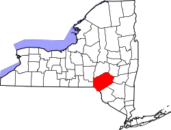
Stamford is located in northeastern Delaware County at 42°25′N74°37′W / 42.417°N 74.617°W / 42.417; -74.617 (42.4116, -74.6189). [4] The village is in the Catskill Mountains. The headwaters of the West Branch Delaware River passes through the center of the village and forms the boundary between the town of Harpersfield to the west and the town of Stamford to the east. Slightly more than half of the village is in the town of Stamford.

New York State Routes 10 and 23 intersect on the west side of the village. NY 10 leads north 24 miles (39 km) to Cobleskill and southwest 20 miles (32 km) to Delhi, while NY 23 leads west 26 miles (42 km) to Oneonta and east 49 miles (79 km) to Catskill.

According to the United States Census Bureau, the village of Stamford has a total area of 1.4 square miles (3.5 km2), of which 0.01 square miles (0.02 km2), or 0.66%, is water. [2]

Demographics

Historical population
CensusPop.Note
1880 522
1890 81956.9%
1900 90110.0%
1910 9738.0%
1920 947−2.7%
1930 1,10316.5%
1940 1,088−1.4%
1950 1,1626.8%
1960 1,1660.3%
1970 1,28610.3%
1980 1,240−3.6%
1990 1,211−2.3%
2000 1,2654.5%
2010 1,119−11.5%
2020 1,040−7.1%
U.S. Decennial Census [5]

As of the census [6] of 2000, there were 1,265 people, 496 households, and 290 families residing in the village. The population density was 954.3 inhabitants per square mile (368.5/km2). There were 621 housing units at an average density of 468.5 per square mile (180.9/km2). The racial makeup of the village was 97.55% White, 0.40% Black or African American, 0.08% Native American, 0.63% Asian, 0.40% from other races, and 0.95% from two or more races. Hispanic or Latino of any race were 3.64% of the population.

There were 496 households, out of which 28.2% had children under the age of 18 living with them, 44.6% were married couples living together, 10.3% had a female householder with no husband present, and 41.5% were non-families. 34.5% of all households were made up of individuals, and 16.1% had someone living alone who was 65 years of age or older. The average household size was 2.28 and the average family size was 2.99.

In the village, the population was spread out, with 22.2% under the age of 18, 6.4% from 18 to 24, 21.1% from 25 to 44, 24.0% from 45 to 64, and 26.2% who were 65 years of age or older. The median age was 45 years. For every 100 females, there were 88.0 males. For every 100 females age 18 and over, there were 83.9 males.

The median income for a household in the village was $30,664, and the median income for a family was $38,864. Males had a median income of $27,500 versus $21,607 for females. The per capita income for the village was $18,012. About 9.4% of families and 15.2% of the population were below the poverty line, including 22.8% of those under age 18 and 13.6% of those age 65 or over.

Attractions

Observatory atop Mount Utsayantha overlooking Stamford Mount Utsayantha Observatory.JPG
Observatory atop Mount Utsayantha overlooking Stamford

The village of Stamford is a stop on the Catskill Scenic Trail, a multi-use rail trail following the former route of the Ulster and Delaware Railroad. [7] Catskill is also home of the Headwaters Trails. [8] Overlooking Stamford on the east is 3,214-foot (980 m) Mount Utsayantha, which includes an observatory and a viewing tower. It is a popular destination for hang-gliding enthusiasts. [9]

A fire lookout tower on Mount Utsayantha Mount Utsayantha fire tower.JPG
A fire lookout tower on Mount Utsayantha

Related Research Articles

<span class="mw-page-title-main">Delaware County, New York</span> County in New York, United States

Delaware County is a county located in the US state of New York. As of the 2020 United States census, the population was 44,308. The county seat is Delhi. The county is named after the Delaware River, which was named in honor of Thomas West, 3rd Baron De La Warr, appointed governor of Virginia in 1609.

<span class="mw-page-title-main">Otsego County, New York</span> County in New York, United States

Otsego County is a county in the U.S. state of New York located within the Mohawk Valley Region. As of the 2020 census, the population was 58,524. The county seat is Cooperstown. The county's population center is Oneonta. The name Otsego is from a Mohawk or Oneida word meaning "place of the rock."

Bovina is a town in Delaware County, New York, United States. The population was 633 at the 2010 census. The name "Bovina" was suggested by General Erastus Root, who noted the area's fitness for grazing. Bovina is an interior town in the eastern part of the county.

Harpersfield is a town in Delaware County, New York, United States. The population was 1,577 at the 2010 census. The town is on the northern border of the county.

Hobart is a village in Delaware County, New York, United States. The population was 441 at the 2010 census. The village is in the town of Stamford and is on New York Route 10 in the northeastern part of the county.

Meredith is a town in Delaware County, New York, United States. The population was 1,529 at the 2010 census. It is an interior town in the northern part of the county.

<span class="mw-page-title-main">Roxbury, New York</span> Town in New York, United States

Roxbury is a town in Delaware County, New York, United States. The population was 2,247 at the 2020 census. The town is at the eastern end of the county.

<span class="mw-page-title-main">Ashland, Greene County, New York</span> Town in New York, United States

Ashland is a town in Greene County, New York, United States. The population was 682 in the 2020 US census, down from 784 in the 2010 census. Ashland is in the northwestern part of the county.

Jefferson Heights is a hamlet and census-designated place (CDP) in Greene County, New York, United States. The population was 1,122 at the 2020 census.

<span class="mw-page-title-main">Jewett, New York</span> Town in New York, United States

Jewett is a town centrally located in Greene County, New York, United States. The population was 953 at the 2010 census. The town is named for Freeborn G. Jewett, justice of the New York Supreme Court.

Leeds is a hamlet and census-designated place (CDP) in Greene County, New York, United States. The population was 377 at the 2010 census.

<span class="mw-page-title-main">Lexington, New York</span> Town in New York, United States

Lexington is a town in Greene County, New York, United States. The population was 770 at the 2020 census. The town is in the southwestern part of Greene County.

<span class="mw-page-title-main">Shandaken, New York</span> Town in New York, United States

Shandaken is a town on the northern border of Ulster County, New York, United States, northwest of Kingston, New York. As of the 2020 census, the town had a total population of 2,866. The name is believed to be from an Esopus phrase for "land of rapid waters."

<span class="mw-page-title-main">West Hurley, New York</span> CDP in New York, United States

West Hurley is a hamlet in Ulster County, New York, United States. The population was 1,917 at the 2020 census.

Delhi is a village in Delaware County, New York, United States. The population was 3,087 at the 2010 census. Delhi is the county seat of Delaware County.

<span class="mw-page-title-main">Hancock (village), New York</span> Village in New York, United States

Hancock is a village in Delaware County, New York, United States. The population was 908 at the 2020 census. The village is in the west part of the town of Hancock at the junction of NY Routes 17 and 97.

<span class="mw-page-title-main">Stamford, New York</span> Village in New York, United States

Stamford is a town in Delaware County, New York, United States. The population was 2,000 at the 2020 census. The town is in the eastern part of the county and has a village called Stamford.

Cairo is a hamlet and census-designated place (CDP) in the town of Cairo in Greene County, New York, United States. The population of the CDP was 1,402 at the 2010 census, out of 6,610 people in the entire town.

<span class="mw-page-title-main">Hunter (village), New York</span> Village in New York, United States

Hunter is a village in Greene County, New York, United States. The population was 429 at the 2020 census, down from 502 at the 2010 census. The village is in the northwestern part of the town of Hunter on Route 23A.

<span class="mw-page-title-main">Hunter, New York</span> Town in New York, United States

Hunter is a town located in Greene County, New York, United States. The population was 2,732 at the time of the 2010 census. The town contains two villages, one named Hunter on the west, and the second called Tannersville, as well as a number of hamlets such as Haines Falls, Platte Clove, Lanesville and Edgewood. Additionally, there are three residential parks location within town limits: Onteora Park, Twilight Park and Elka Park. The town is on the southern border of Greene County and abuts the towns of Woodstock and Saugerties, located in Ulster County.

References

  1. "ArcGIS REST Services Directory". United States Census Bureau. Retrieved September 20, 2022.
  2. 1 2 "Geographic Identifiers: 2010 Demographic Profile Data (G001): Stamford village, New York". U.S. Census Bureau, American Factfinder. Archived from the original on February 13, 2020. Retrieved November 10, 2015.
  3. "National Register Information System". National Register of Historic Places . National Park Service. July 9, 2010.
  4. "US Gazetteer files: 2010, 2000, and 1990". United States Census Bureau. 2011-02-12. Retrieved 2011-04-23.
  5. "Census of Population and Housing". Census.gov. Retrieved June 4, 2015.
  6. "U.S. Census website". United States Census Bureau . Retrieved 2008-01-31.
  7. catskillscenictrail.org
  8. headwaterstrailsny.org
  9. localhikes.com