Letchworth State Park is a 14,427-acre (5,838 ha) New York State Park located in Livingston County and Wyoming County in the western part of the State of New York. The park is roughly 17 miles (27 km) long, following the course of the Genesee River as it flows north through a deep gorge and over several large waterfalls. It is located 35 miles (56 km) southwest of Rochester and 60 miles (97 km) southeast of Buffalo, and spans portions of the Livingston County towns of Leicester, Mount Morris and Portage, as well as the Wyoming County towns of Castile and Genesee Falls.

Falls Church is an independent city in the Commonwealth of Virginia, United States. As of the 2020 census, the population was 14,658. Falls Church is included in the Washington metropolitan area.

Minnehaha County is a county on the eastern border of the state of South Dakota. As of the 2020 census, the population was 197,214, making it the state's most populous county. It contains over 20% of the state's population. Its county seat is Sioux Falls, South Dakota's largest city. The county was created in 1862 and organized in 1868. Its name was derived from the Sioux word Mnihaha, meaning "rapid water," or "waterfall".

Montour Falls is a village located in Schuyler County, New York, United States. The population was 2,714 at the time of the 2020 census. A waterfall at the end of West Main Street gives the village its name. The name "Montour" is derived from Queen Catharine Montour, a prominent Native American woman of Seneca Indian heritage who lived at the village site in the 18th century.

Clifton is a town in St. Lawrence County, New York, United States. The population was 675 at the 2020 census. The town takes its name from a mining company.

The Youngs River is a tributary of the Columbia River, approximately 27 miles (43 km) long, in northwest Oregon in the United States. It drains part of the Northern Oregon Coast Range in the extreme northwest corner of state, entering the Columbia via Youngs Bay just approximately 10 miles (16 km) from its mouth.

U.S. Route 53, or U.S. Highway 53 (U.S. 53), is a north–south U.S. highway that runs for 404 miles (650 km) from La Crosse, Wisconsin to International Falls, Minnesota. It is the primary north–south route in northwestern Wisconsin, serving as a vital link between I-94 at Eau Claire, Wisconsin and the Twin Ports of Superior, Wisconsin, and Duluth, Minnesota. The entire route from Eau Claire to the city limits of Superior is a four lane divided highway. The highway's northern terminus is at the Fort Frances–International Falls International Bridge in International Falls, Minnesota, at the Canada–US border. Its southern terminus is in La Crosse, Wisconsin, at U.S. Highway 14.

Texas's 13th congressional district is a congressional district in the U.S. state of Texas that includes most of the Texas Panhandle, parts of Texoma and northwestern parts of North Texas. The principal cities in the district are Amarillo, Gainesville and Wichita Falls. It winds across the Panhandle into the South Plains, then runs east across the Red River Valley. Covering over 40,000 square miles (100,000 km2), it is the 19th-largest district by area in the nation, the 14th-largest that does not cover an entire state, as well as the second-largest in Texas behind the 23rd congressional district. It covers more land mass than thirteen entire states. After the 2020 census was completed, the 13th district was heavily redrawn to incorporate Denton, an increasingly Democratic-leaning suburb of the Dallas-Fort Worth metroplex which had previously anchored the 26th district.

Yellowstone Falls consist of two major waterfalls on the Yellowstone River, within Yellowstone National Park, Wyoming, United States. As the Yellowstone river flows north from Yellowstone Lake, it leaves the Hayden Valley and plunges first over Upper Falls of the Yellowstone River and then a quarter mile downstream over Lower Falls of the Yellowstone River, at which point it then enters the Grand Canyon of the Yellowstone, which is up to 1,000 feet deep.

Connecticut's 3rd congressional district is a congressional district in the U.S. state of Connecticut. Located in the central part of the state, the district includes the city of New Haven and its surrounding suburbs.
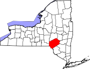
New York's 21st congressional district is a congressional district for the United States House of Representatives that is currently represented by Republican Elise Stefanik.
Wisconsin's 3rd congressional district covers most of the Driftless Area in southwestern and western Wisconsin. The district includes the cities of Eau Claire, La Crosse, and Stevens Point, as well as many Wisconsin-based exurbs of the Minneapolis-St. Paul metropolitan area. It borders the states of Minnesota, Iowa, and Illinois. Republican Derrick Van Orden has represented the district since 2023.
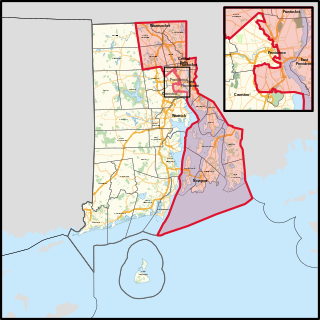
Rhode Island's 1st congressional district is a congressional district in the U.S. state of Rhode Island. It includes all of Bristol and Newport counties, along with parts of Providence County, including most of the city of Providence.

Northern Illinois is a region generally covering the northern third of the U.S. state of Illinois. The region is by far the most populous of Illinois with nearly 9.7 million residents as of 2010.

Montana's 1st congressional district is a congressional district in the United States House of Representatives that was apportioned after the 2020 United States census. The first candidates ran in the 2022 elections for a seat in the 118th United States Congress.
Ash Lake is an unincorporated community in Saint Louis County, Minnesota, United States; located within the Kabetogama State Forest.

Idaho's 2nd congressional district is one of two congressional districts in the U.S. state of Idaho, in the eastern portion of the state. Beginning with the 2012 election, the district expanded westward and now includes most of Boise, the state capital and largest city. The district is currently represented by Mike Simpson, a Republican of Idaho Falls. A former dentist in Blackfoot, he was first elected in 1998; the seat opened when his predecessor Mike Crapo successfully ran for the U.S. Senate.
Ray is an unincorporated community in Koochiching County, Minnesota, United States.

The 2000 United States presidential election in Minnesota took place on November 7, 2000, as part of the 2000 United States presidential election, which was held throughout all 50 states and D.C. Voters chose ten representatives, or electors to the Electoral College, who voted for president and vice president.
The Pat Bayle State Forest is a state forest located near the town of Grand Marais in Cook County, Minnesota. The forest falls within the limits of the Superior National Forest, and falls under the federal jurisdiction of the United States Forest Service.