Napoli is a town in Cattaraugus County, New York, United States. It is located in the western half of the county, northwest of Salamanca. The only permanent community in the town is Napoli village, formerly "Napoli Corners". The population was 1,173 at the 2020 census.

Russia is a town in Herkimer County, New York, United States. The population was 2,587 at the 2010 census. The town is located in the northwestern part of the county and is northeast of Utica.
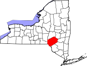
Philipstown is a town located in the western part of Putnam County, New York, United States. The population was 9,831 at the 2020 census.

Cold Spring Harbor is a hamlet and census-designated place (CDP) in the Town of Huntington, in Suffolk County, on the North Shore of Long Island in New York. As of the 2010 United States census, the CDP population was 5,070.
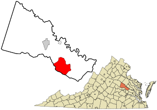
Mechanicsville is an unincorporated area and census-designated place (CDP) in Hanover County, Virginia, United States. The population was 39,482 during the 2020 census, up from 36,348 in the 2010 census.

The Mohawk River is a 149-mile-long (240 km) river in the U.S. state of New York. It is the largest tributary of the Hudson River. The Mohawk flows into the Hudson in Cohoes, New York, a few miles north of the city of Albany. The river is named for the Mohawk Nation of the Iroquois Confederacy. It is a major waterway in north-central New York. In the early 19th century, the river's east-west valley provided the setting and water for development of the Erie Canal, as a key to developing New York. The largest tributary, the Schoharie Creek, accounts for over one quarter (26.83%) of the Mohawk River's watershed. Another main tributary is the West Canada Creek, which makes up for 16.33% of the Mohawk's watershed.

The Chenango River is a 90-mile-long (140 km) tributary of the Susquehanna River in central New York in the United States. It drains a dissected plateau area in upstate New York at the northern end of the Susquehanna watershed.
Fillmore is a hamlet in the town of Hume, Allegany County, New York, United States. As of the 2010 census it had a population of 603. It was originally known as "The Mouth of the Creek" but was named for President Millard Fillmore in 1850. The former village of Fillmore dissolved its incorporation and is now simply a named hamlet southeast of the town center of Hume. Fillmore is the mailing address of the Hungarian Scout Camp, the main campsite of the Hungarian Scout Association in Exteris, although the camp is technically within the neighboring town of Granger. Fillmore is also the site of the Most Holy Family Monastery which was deemed a hate group by the anti-Catholic Southern Poverty Law Center (SPLC) in February 2017.

The Beaver Kill, sometimes written as the Beaverkill or Beaverkill River, is a tributary of the East Branch Delaware River, a main tributary of the Delaware River, approximately 44 miles (71 km) long, in the U.S. state of New York. The kill drains a 300-square-mile (780 km2) area of the Catskill Mountains and has long been celebrated as one of the most famous trout streams in the United States. Its preservation helped establish many of the basic conservation principles of rivers in the United States.

The West Branch Delaware River is one of two branches that form the Delaware River. It is approximately 90 mi (144 km) long, and flows through the U.S. states of New York and Pennsylvania. It winds through a mountainous area of New York in the western Catskill Mountains for most of its course, before joining the East Branch along the northeast border of Pennsylvania with New York. Midway or so it is empounded by the Cannonsville Dam to form the Cannonsville Reservoir, both part of the New York City water supply system for delivering drinking water to the City.

The Cacapon River, located in the Appalachian Mountains of West Virginia's Eastern Panhandle region, is an 81.0-mile-long (130.4 km) shallow river known for its fishing, boating, wildlife, hunting, and wilderness scenery. As part of the Potomac River watershed, it is an American Heritage River.

Wiscoy Creek is a stream, approximately 15 miles (24 km) long, in western New York in the United States. It is a tributary of the Genesee River. The creek was known to Native Americans as O-wa-is-ki, meaning "under the banks".
Oaks Creek is a river that drains Canadarago Lake, which is situated in the north central region of Otsego County, New York. The creek begins by the Hamlet of Schuyler Lake and flows southeast approximately 9.32 miles (15.00 km), dropping only 105 feet (32 m) in elevation, before converging with the Susquehanna River south of the Village of Cooperstown, by the Hamlet of Index. From the source to Oaksville the creek flows along Panther Mountain. Fly Creek is a main tributary, that converges with Oaks Creek south of the Hamlet of Fly Creek.

The Canajoharie Creek is a river that flows into the Mohawk River in the Village of Canajoharie in the U.S. State of New York. The name "Canajoharie" is a Mohawk language term meaning "the pot that washes itself", referring to the "Canajoharie Boiling Pot", a 20-foot (6.1 m) wide and 10-foot (3.0 m) deep pothole in the Canajoharie Creek, just south of the village of Canajoharie. Bowmans Creek is one main tributary that enters the creek east of the Hamlet of Sprout Brook. The other main tributary is Brimstone Creek which enters the creek north-northwest of the Village of Ames.
Beales Pond is a small lake located south of the hamlet of Masonville in Delaware County, New York. Beales Pond drains south via East Branch Cold Spring Creek which flows into Cold Spring Creek, which flows into the West Branch Delaware River.
Barbourville is a hamlet in Delaware County, New York, United States. It is located northeast of Stilesville on NY Route 8. The East Branch Cold Spring Creek flows south through the hamlet.
Upper Barbourville is a hamlet in Delaware County, New York, United States. It is located northeast of Stilesville on NY Route 8. The East Branch Cold Spring Creek flows south through the hamlet.
China is a hamlet in Delaware County, New York, United States. It is located north-northeast of Deposit on China Road at its intersection with Schofield Road. Cold Spring Creek flows south through the hamlet.
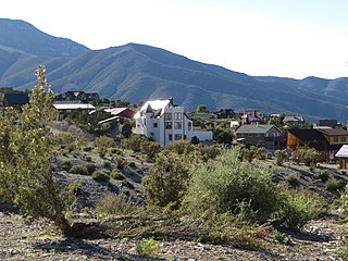
Cold Creek is an unincorporated community in Clark County, Nevada, United States located within the Spring Mountains National Recreation Area and approximately 28 miles by road from the Las Vegas city limits. Cold Creek is named for the stream that flows through the community.