
The West Branch Delaware River is one of two branches that form the Delaware River. It is approximately 90 mi (144 km) long, and flows through the U.S. states of New York and Pennsylvania. It winds through a mountainous area of New York in the western Catskill Mountains for most of its course, before joining the East Branch along the northeast border of Pennsylvania with New York. Midway or so it is empounded by the Cannonsville Dam to form the Cannonsville Reservoir, both part of the New York City water supply system for delivering drinking water to the City.

The Chippewa River is a stream in Michigan, United States, that runs 91.8 miles (147.7 km) through the central Lower Peninsula. The Chippewa is a tributary of the Tittabawassee River and is thus part of the Saginaw River drainage basin. The river is named after the Chippewa people.

Wappinger Creek is a 41.7-mile-long (67.1 km) creek which runs from Thompson Pond to the Hudson River at New Hamburg in Dutchess County, New York, United States. It is the longest creek in Dutchess County, with the largest watershed in the county.
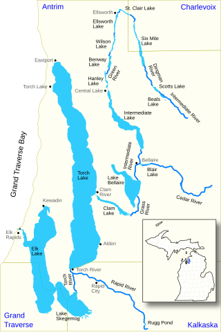
The Elk River Chain of Lakes Watershed, commonly known as the Chain of Lakes, is a 75-mile-long (121 km) waterway consisting of 14 lakes and connecting rivers in the northwestern section of the Lower Peninsula of the U.S. state of Michigan, which empty into Lake Michigan.

Poyntelle is a village that is located in Preston Township, Wayne County, Pennsylvania, United States, in the Lake Region of the Poconos.

The Middle Fork Stanislaus River is a 45.7-mile (73.5 km) tributary of the Stanislaus River in the central Sierra Nevada and Stanislaus National Forest of eastern California.

Thomes Creek is a major watercourse on the west side of the Sacramento Valley in Northern California. The creek originates in the Coast Ranges and flows east for about 62 miles (100 km) to join the Sacramento River, at a point about 7 miles (11 km) northeast of Corning in Tehama County.

Butternut Creek is a 37-mile-long (60 km) river in the state of New York. It converges with the Unadilla River just downstream of Mount Upton. The creek has many fish for fishing dominated by largemouth bass, smallmouth bass, wall-eye, chain pickerel, rock bass, and yellow perch.

Steele Creek is a river in Herkimer County in the state of New York. The creek begins in an unnamed swamp south of Cedarville, and flows in a northeast direction before emptying into the Mohawk River in the village of Ilion. Steele Creek travels through the Ilion Gorge and alongside NY-51 for most of its length. Steele Creek derives its name from Rudolph Stahl, who built the first grist mill in Ilion along the creek.
Charlotte Creek is a river located in Delaware County, New York. Charlotte Creek borders the southern border of Otsego County, New York for a few miles near the mouth. The creek converges with the Susquehanna River by Emmons, New York.
Read Creek is a river in Delaware County, New York. It drains Merrick Pond and flows east until it meets the unnamed creek that drains Trask Pond, then begins flowing south receiving its other tributaries before converging with the East Branch Delaware River northeast of Fishs Eddy.
Lake Brook is a river in Delaware County, New York. It drains Odell Lake and flows south before converging with the West Branch Delaware River west of Hobart.
Wright Brook is a river in Delaware County, New York. It drains Creamery Pond and flows south before converging with the West Branch Delaware River south of Bloomville.

Oquaga Creek is a river in Broome County and Chenango County in New York. It flows into the West Branch Delaware River by Deposit, New York.
Roods Creek is a river in Delaware County, New York. It begins just south of Cannonsville Reservoir and flows south into Crystal Lake. After exiting Crystal Lake it continues flowing south and then flows into Silver Lake. After exiting Silver Lake it continues southward before converging with the West Branch Delaware River east of the hamlet of Hale Eddy.
Beers Brook is a river in Delaware County, New York. It flows into the West Branch Delaware River by Beerston. Beers Brook flows through Russ Gray Pond.
Currant Creek is a stream in eastern Juab County and southern Utah County in northern Utah, United States.
East Branch Cold Spring Creek is a river in Delaware County, New York. It drains Beales Pond and converges with Cold Spring Creek north of Stilesville.
Beales Pond is a small lake located south of the hamlet of Masonville in Delaware County, New York. Beales Pond drains south via East Branch Cold Spring Creek which flows into Cold Spring Creek, which flows into the West Branch Delaware River.
Clarks Pond is a small lake located south-southeast of the hamlet of Masonville in Delaware County, New York. Clarks Pond drains south via Cold Spring Creek which flows into the West Branch Delaware River.
