Davenport Center, New York | |
|---|---|
 Davenport Center | |
| Coordinates: 42°26′53″N74°55′8″W / 42.44806°N 74.91889°W [1] | |
| Country | United States |
| State | New York |
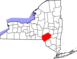
| County | Delaware County |
| Town | Davenport |
| Area | |
• Total | 3.14 sq mi (8.14 km2) |
| • Land | 3.10 sq mi (8.04 km2) |
| • Water | 0.04 sq mi (0.10 km2) |
| Elevation | 1,221 ft (372 m) |
| Population (2020) | |
• Total | 344 |
| • Density | 110.86/sq mi (42.80/km2) |
| Time zone | UTC-5 (Eastern (EST)) |
| • Summer (DST) | UTC-4 (EDT) |
| ZIP Codes |
|
| Area code | 845 |
| FIPS code [3] | 36-19774 |
| GNIS feature ID [1] | 948049 |
| Website | Town of Davenport |
Davenport Center is a hamlet and census-designated place (CDP) in the town of Davenport, Delaware County, New York, United States. The population was 349 at the 2010 census. [3]