
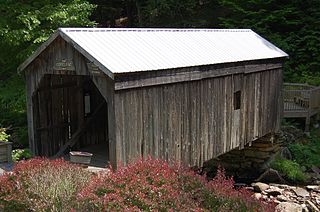
Perrine's Bridge is the second-oldest covered bridge in the State of New York, after the Hyde Hall Bridge in East Springfield. Once located in the hamlet called Perrines Bridge between 1850 and 1861. It is located in the modern day town of Esopus-Rosendale, New York just a few hundred feet to the east of Interstate 87 crossing of the Wallkill River in Ulster County, New York. Originally built to aid in the movement of trade between the towns of Rifton and Rosendale, the bridge is about 90 miles north of New York city between mile markers 81 and 82 on the New York State Thruway. In May 1834 the State of New York authorized and provided money ($700) to Ulster county, NY, to build the bridge. In 1835, the bridge was built by Benjamin Wood, the one-lane wooden covered bridge has been closed to vehicular traffic since 1930. The Bridge derives its name from James W. Perrine, a descendant of Daniel Perrin "The Huguenot", who was a tavern keeper that opened an inn on the east side of that future bridge in 1820. Perrine's son was hired each winter as the "snower". He would spread snow the length of the structure so horse-drawn sleighs could cross.

This is a list of properties and districts listed on the National Register of Historic Places in Pennsylvania. As of 2015, there are over 3,000 listed sites in Pennsylvania. All 67 counties in Pennsylvania have listings on the National Register.
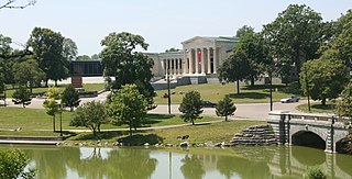
Delaware Park–Front Park System is a historic park system and national historic district in the northern and western sections of Buffalo in Erie County, New York. The park system was designed by Frederick Law Olmsted and Calvert Vaux and developed between 1868 and 1876.

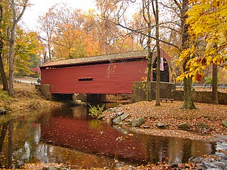
The Columbia Bridge is a covered bridge, carrying Columbia Bridge Road over the Connecticut River between Columbia, New Hampshire and Lemington, Vermont. Built in 1911–12, it is one of only two New Hampshire bridges built with Howe trusses, and is one of the last covered bridges built in the historic era of covered bridge construction in both states. It was listed on the National Register of Historic Places in 1976.

Old Blenheim Bridge was a wooden covered bridge that spanned Schoharie Creek in North Blenheim, New York, United States. With an open span of 210 feet (64 m), it had the second longest span of any surviving single-span covered bridge in the world. The 1862 Bridgeport Covered Bridge in Nevada County, California, currently undergoing repairs due to 1986 flooding is longer overall at 233 feet (71 m) but is argued to have a 208 feet (63 m) clear span. The bridge, opened in 1855, was also one of the oldest of its type in the United States. It was destroyed by flooding resulting from Tropical Storm Irene in 2011. Rebuilding of the bridge commenced in 2017 and was completed in 2018.

The McAllister Covered Bridge is a Burr Arch structure that was built by Joseph A. Britton and Son in 1914. It is 144 feet (44 m) long, 16 feet (4.9 m) wide, and 14 feet (4.3 m) high. It is found in Adams Township, Parke County, Indiana, United States.

Hamden Bridge is a wooden covered bridge over the West Branch of the Delaware River in the hamlet of Hamden in Delaware County, New York. It was built in 1859, and is a single span, timber and plan framed bridge. It measures 128 feet long and 18 feet wide. A supporting center pier was added in 1940.
Downsville is a hamlet, census-designated place (CDP), and former village in the town of Colchester, Delaware County, New York, United States. The population was 617 at the 2010 census.

Salisbury Center Bridge is the only covered bridge in Herkimer County, New York State. It was built in 1875, and is a wood frame Burr Truss bridge measuring 42 feet long and 16 feet wide. The bridge has vertical board siding and is topped by a gable roof. The wooden bridge is one of 29 covered bridges in New York State.
Copeland Bridge, also known as Copeland Farm Bridge or Copeland Covered Bridge is a wooden covered bridge over Beecher Creek in the town of Edinburg in Saratoga County, New York. It was built in 1879, and is a small, timber framed, queenpost truss bridge with a gable roof. It has a 30-foot span carried on fieldstone abutments.

Fitch's Bridge is a wooden covered bridge over the West Branch of the Delaware River. It is in the town of Delhi and is one of 24 covered bridges in New York State. It was originally erected in 1870 in the village of Delhi, and moved to its present location in 1885. The single-span, timber bridge measures 106 feet (32 m) long and 20 feet (6.1 m) wide.

Lower Shavertown Bridge is a wooden covered bridge over Trout Creek in the town of Hancock in Delaware County, New York, USA. It was originally erected in the hamlet of Shaverton in 1877 as a crossing of Lower Beech Hill Brook, and moved to its present location at Methol in 1954. It is 32 feet long and is a wood-plank-framed, gable-roofed, single-span bridge. It is one of 29 covered bridges in New York State.

The Grant Mills Bridge, officially the Millbrook Bridge, is a wooden covered bridge over Mill Brook in Hardenburgh, New York, United States. It is one of 29 covered bridges in the state.

Ashokan Bridge is a wooden covered bridge over Esopus Creek on the grounds of the Ashokan Center, in Ulster County, New York, United States. It was built in 1885, and is a single span, gable roofed, covered timber bridge. It measures 72 feet, 6 inches, long and 16 feet, 4 inches, wide. It was originally located at Turnwood and moved to its present location in 1939. It is situated in the Ashokan Center, which was formerly the Ashokan Field Campus of the State University of New York at New Paltz.
Delaware and Hudson Railroad Bridge is a pair of historic Warren Steel Truss bridges over the Ausable River at AuSable and Peru in Clinton County, New York. Also known as the Delaware and Hudson Ausable River Bridge, they were built by the American Bridge Company for the Delaware and Hudson Railway in 1913. The North Bridge is 156 feet in length and the South Bridge 173 feet. They are both 16 feet wide and 25 feet in height.

Union Free School is a historic school building located at Downsville in Delaware County, New York, United States. It was built in 1903-1906 and is a large T-shaped wood-framed building on a raised foundation of concrete and bluestone. The main section of the school is two and one half stories with a hipped roof and features a decorative belfry.

The Delaware and Hudson Railroad Freight House is a historic railroad building located at Cohoes, Albany County, New York. The freight house was built in 1910 by the Delaware and Hudson Railway. It is a one-story, rectangular brick building on a raised, battered concrete basement. It measures approximately 40 feet (12 m) wide and 300 feet (91 m) long, and has a low pitched gable roof.
Bartram's Covered Bridge, a historic covered bridge built in 1860, uses a Burr Truss design and carried Goshen Road over Crum Creek on the border between Delaware County and Chester County, Pennsylvania. It is 30 feet (9.1 m) long and 13 feet (4.0 m) wide and is the only covered bridge remaining of the 30 which once stood in Delaware County. The bridge has slanted planks at each entrance and is the only covered bridge in Pennsylvania with this feature. According to an on-site marker from the Newtown Square Historical Preservation Society, the bridge was built to be "hi and wide as a load of hay" It was built by Ferdinand Wood and named for Mordecai Bartram.

Wooddale Bridge is a covered bridge over Red Clay Creek at Wooddale in New Castle County, Delaware. It is one of three covered bridges in the state of Delaware along with the very similar Ashland Covered Bridge and the Smith Bridge. It and the Ashland bridge remain, of the thirteen bridges along the Red Clay Creek that were marked on an 1868 map.

The Kidder Covered Bridge carries Kidder Hill Road across the South Branch Saxtons River, just south of the village center of Grafton, Vermont. The bridge was built about 1870, and is Grafton's last surviving 19th-century covered bridge. It is the shortest historic covered bridge in Windham County, and was listed on the National Register of Historic Places in 1973.


