Charing Cross Road is a street in central London running immediately north of St Martin-in-the-Fields to St Giles Circus, which then merges into Tottenham Court Road. It leads from the north in the direction of Charing Cross at the south side of Trafalgar Square. It connects via St Martin's Place and the motorised east side of the square.
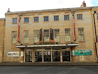
The Oxford Playhouse is a theatre designed by Edward Maufe and F. G. M. Chancellor. It is situated in Beaumont Street, Oxford, opposite the Ashmolean Museum.
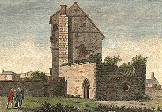
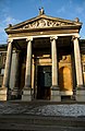
Beaumont Palace, built outside the north gate of Oxford, was intended by Henry I about 1130 to serve as a royal palace conveniently close to the royal hunting-lodge at Woodstock. Its former presence is recorded in Beaumont Street, Oxford. Set into a pillar on the north side of the street, near Walton Street, is a stone with the inscription: "Near to this site stood the King's Houses later known as Beaumont Palace. King Richard I was born here in 1157 and King John in 1166." The "King's House" was the range of the palace that contained the king's lodgings.

The High Street in Oxford, England, known locally as the High, runs between Carfax, generally seen as the centre of the city, and Magdalen Bridge to the east.

Broad Street is a wide street in central Oxford, England, just north of the former city wall. The street is known for its bookshops, including the original Blackwell's bookshop at number 50, located here due to the University of Oxford. Among residents, the street is traditionally known as The Broad. On the street is a memorial paving for the Oxford Martyrs.
St Giles' is a wide boulevard leading north from the centre of Oxford, England. At its northern end, the road divides into Woodstock Road to the left and Banbury Road to the right, both major roads through North Oxford. At the southern end, the road continues as Magdalen Street at the junction with Beaumont Street to the west. Also to the west halfway along the street is Pusey Street. Like the rest of North Oxford, much of St Giles' is owned by St John's College.

The Randolph Hotel, also known as The Randolph Hotel by Graduate Hotels, is a 5 star hotel in Oxford, England, on the south side of Beaumont Street, at the corner with Magdalen Street, opposite the Ashmolean Museum and close to the Oxford Playhouse. The hotel building is in the Victorian Gothic style.

Parks Road is a road in Oxford, England, with several Oxford University colleges along its route. It runs north–south from the Banbury Road and Norham Gardens at the northern end, where it continues into Bradmore Road, to the junction with Broad Street, Holywell Street and Catte Street to the south.
St Aldate's is a street in central Oxford, England, named after Saint Aldate, but formerly known as Fish Street.

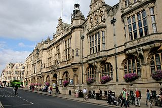
George Street is a street in central Oxford, England. It is a shopping street running east–west.

Walton Street is on the eastern edge of the Jericho district of central Oxford, England.

Clarendon Palace is a medieval ruin 2+1⁄4 miles (3.6 km) east of Salisbury in Wiltshire, England. The palace was a royal residence during the Middle Ages, and was the location of the Assize of Clarendon which developed the Constitutions of Clarendon. It now lies within the grounds of Clarendon Park.

New College Lane is a historic street in central Oxford, England, named after New College, one of the older Oxford colleges, adjacent to the north.
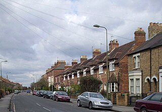
Kingston Road is a road in Oxford, England. It continues north from Walton Street, at the junction with Walton Well Road to the west and St Bernard's Road to the east, running parallel with and to the west of Woodstock Road. Kingston Road is the main road in Walton Manor. At the northern end, there is a staggered junction with Aristotle Lane to the west and Polstead Road to the east. The road continues as Hayfield Road. Southmoor Road and Southmoor Place lead off Kingston Road to the west.

Hythe Bridge Street is in the west of central Oxford, England, forming part of the A4144 road.

Worcester Street is a street in west central Oxford, England.

Observatory Street is a street in Oxford, England. It links at the eastern end Woodstock Road in central North Oxford and at the western end Walton Street and the Jericho area of Oxford, England.

Walton Well Road is a road, about 400 metres long, near the centre of Oxford, England. It provides a link from central Oxford to Port Meadow.

The City of Oxford and District Tramway Company and its successor the City of Oxford Electric Traction Company operated a horse-drawn passenger tramway service in Oxford between 1881 and 1914. The tramway was unusual for having a track gauge of only 4 feet (1.219 m).

Chiltern Street is a road in the Marylebone area of Central London. Located in the City of Westminster, it runs north to south connecting Marylebone Road and Blandford Street. Baker Street runs parallel a little way to the west. It meets Dorset Street, Crawford Street and Paddington Street along its route. Manchester Square is located beyond the southern end of the street.