
Beaver County is a county in the Commonwealth of Pennsylvania. As of the 2020 census, the population was 168,215. Its county seat is Beaver, and its largest city is Aliquippa. The county was created on March 12, 1800, from parts of Allegheny and Washington counties. It took its name from the Beaver River.

Lake Montezuma is a census-designated place (CDP) in Yavapai County in the U.S. state of Arizona. The population was 5,111 at the 2020 census. The CDP includes the communities of Rimrock and McGuireville. Located along Interstate 17, it is 20 miles (32 km) south of Sedona and 8 miles (13 km) north of Camp Verde in central Arizona's Verde Valley.
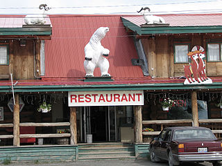
Beaver Creek is a community in Yukon, Canada. Located at kilometre 1870.6 of the Alaska Highway, 1 NM southeast of Beaver Creek Airport and close to the Alcan - Beaver Creek Border Crossing, it is Canada's westernmost community. The community's main employers are a Canada Border Services Agency port, the White River First Nation and a number of tourist lodges.

Port Alberni is a city located on Vancouver Island in the province of British Columbia, Canada. The city lies within the Alberni Valley at the head of the Alberni Inlet, Vancouver Island's longest inlet. It is the location of the head offices of the Alberni-Clayoquot Regional District. Port Alberni currently has a total population of 18,259.

Coombs is a small community on Vancouver Island in the Regional District of Nanaimo, British Columbia, situated on provincial highway 4A approximately 10 km (6.2 mi) west of Parksville. Coombs is home to approximately 1,327 people and is renowned for its Old Country Market, Butterfly World, the 106 year old Coombs Fall Fair and the Coombs Bluegrass Festival held every B.C. Day weekend. The history of Coombs goes back many years. The Ford House which is the old log house situated on the Alberni Highway is dated back to the early 1900s. The pioneer Walter Ford house was completed in 1911. Next to the Ford House is the Dutch Store since year 2021, prior, 1912 to 2021 it was the old General Store, which also always housed the General Post Office. The Coombs Fair Grounds is an active place throughout the year. The Rodeo Grounds just up the highway heading towards Port Alberni is a successful and active place during the summer months. The railway line is also a huge part of the history of Coombs. Along with the United Church and just over the French Creek Bridge is the French Creek School, opened in 1912, which closed in 2015 but is used now as a Coombs Community Commons. French Creek school was a huge asset to the community for over 100 years.
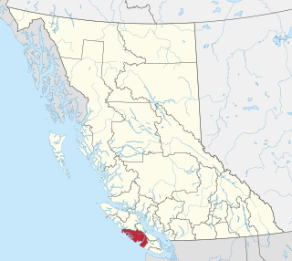
The Alberni–Clayoquot Regional District of British Columbia is located on west central Vancouver Island. Adjacent regional districts it shares borders with are the Strathcona and Comox Valley Regional Districts to the north, and the Nanaimo and Cowichan Valley Regional Districts to the east. The regional district offices are located in Port Alberni.

Beaver Creek is an unincorporated community in Eagle County, Colorado, United States. Beaver Creek is located immediately south of the town of Avon and encompasses the Beaver Creek Resort and adjacent business, lodging, golf course, and residential areas. The U.S. Post Office at Avon serves Beaver Creek postal addresses.

Fossli Provincial Park is a provincial park in British Columbia, Canada, located on Stirling Arm of Sproat Lake on Vancouver Island. The 52-hectare park, west of Port Alberni, is accessible by water or private logging road. It has few services, but has a 30-minute hiking trail to an old homestead site. The homestead belonged to Helen and Armour Ford, who donated the land for the park to the province in 1974. Saint Andrew's Creek runs through the park, and is a fall spawning ground for coho salmon.
Nitinat River Provincial Park is a provincial park in the Canadian province of British Columbia on Vancouver Island.
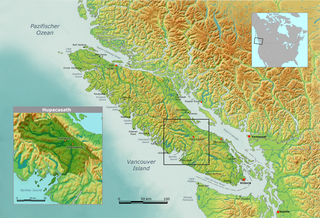
The Hupacasath First Nation is a First Nations government based in the Alberni Valley on the west coast of Vancouver Island in British Columbia, Canada. It is a member of the Nuu-chah-nulth Tribal Council. An alternate spelling of Hupacasath is Opetchesaht or Opitchesaht. Hupacasath First Nation consists of approximately 300 members across five reserves.

Alberni Valley is a broad valley located at the head of Alberni Inlet on Vancouver Island in British Columbia, Canada. It is home to Port Alberni, Sproat Lake and other outlining areas. The term is largely used as a synonym for Greater Port Alberni and adjoining communities but is used in a larger regional sense as well. Various local organizations and companies use the term "Alberni Valley" in their name, e.g. the Alberni Valley Times and Alberni Valley News newspapers the Alberni Valley Chamber of Commerce and the Alberni Valley Bulldogs minor hockey team. The Canadian pioneer, Joe Drinkwater lived in Alberni Valley during the late nineteenth and early twentieth centuries.
Manley is an unincorporated community in Beaver Creek Township, Rock County, Minnesota, United States.

Beaver Creek is an unincorporated community in eastern Washington County, Maryland, United States. Its population was 251 as of the 2010 census. It is located southeast of Hagerstown and north of Boonsboro near U.S. Route 40 and Maryland Route 66. The community is officially included in the Hagerstown Metropolitan Area. This town was founded in 1766.

Beaver Dam is an unincorporated community in Franklin Township, Kosciusko County, in the U.S. state of Indiana.

Klitsa Mountain is a prominent mountain on Vancouver Island, British Columbia, Canada, located 26 km (16 mi) west of Beaver Creek and 59 km (37 mi) southeast of Golden Hinde. It can be viewed from Highway 4 along Sproat Lake. It is the second highest mountain in the Alberni Valley area, after Mount Arrowsmith. its name derives from a Nuu-Chah-Nulth word meaning "always white".

Beaver is an unincorporated community in Whitewater Township, Winona County, Minnesota, United States, located near the junction of State Highway 74 and Winona County Road 30. Nearby places include Altura, Elba, Plainview, St. Charles, Weaver, and Whitewater State Park. The Whitewater River and Beaver Creek both flow through the area.

Lawrence County is a county in the Commonwealth of Pennsylvania. As of the 2020 census, the population was 86,070. The county seat is New Castle.
Beaver is an unincorporated community located in the town of Beaver, Marinette County, Wisconsin, United States. Beaver is located along U.S. Route 141 3 miles (4.8 km) north-northeast of Pound.

Rome is an unincorporated community in southern Douglas County, Missouri, United States. It is located on Beaver Creek, approximately 10 miles (16 km) southwest of Ava on a county road one-half mile off the end of Route A and 3 miles (4.8 km) west of Smallett. Arno lies on Beaver Creek, about 7 miles (11 km) north and Brownbranch in Taney County lies on Beaver Creek, 4.6 miles (7.4 km) to the southwest.
