
The Illinois River is a principal tributary of the Mississippi River and is approximately 273 miles (439 km) long. Located in the U.S. state of Illinois, it has a drainage basin of 28,756.6 square miles (74,479 km2). The Illinois begins where the Des Plaines River and the Kankakee River converge, and its drainage basin extends into southeastern Wisconsin, northwestern Indiana, and a very small area of southwestern Michigan in addition to central Illinois.

Dodge County is a county located in the U.S. state of Wisconsin. As of the 2020 census, the population was 89,396. Its county seat is Juneau. The county was created from the Wisconsin Territory in 1836 and organized in 1844.

The Wisconsin River is a tributary of the Mississippi River in the U.S. state of Wisconsin. At approximately 430 miles (692 km) long, it is the state's longest river. The river's name, first recorded in 1673 by Jacques Marquette as "Meskousing", is rooted in the Algonquian languages used by the area's American Indian tribes, but its original meaning is obscure. French explorers who followed in the wake of Marquette later modified the name to "Ouisconsin", and so it appears on Guillaume de L'Isle's map. This was simplified to "Wisconsin" in the early 19th century before being applied to Wisconsin Territory and finally the state of Wisconsin.
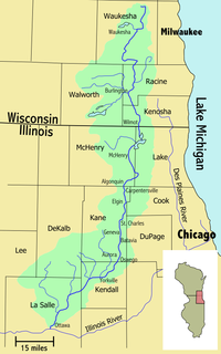
The Fox River is a 202-mile-long (325 km) tributary of the Illinois River, flowing from southeastern Wisconsin to Ottawa, Illinois in the United States. The Wisconsin section was known as the Pishtaka River in the 19th century. There is another Fox River in Wisconsin that flows through Lake Winnebago into Green Bay. There are also two other "Fox Rivers" in southern Illinois: the Fox River and a smaller "Fox River" that joins the Wabash River near New Harmony, Indiana.

Lake Winnebago is a shallow freshwater lake in the north central United States, located in east central Wisconsin. At 137,700 acres it is the largest lake entirely within the state, covering an area of about 30 miles by 10 miles, with 88 miles of shoreline, an average depth of 15.5 feet, and a maximum depth of 21 feet. It has many shallow reefs along the west shore, and a drop-off type shoreline on the east. There are several islands along the west shore.

The Rock River is a tributary of the Mississippi River, approximately 299 miles (481 km) long, in the U.S. states of Wisconsin and Illinois. The river was known as the Sinnissippi to Sauk and Fox Indians; the name means "rocky waters".

Lake Wisconsin is a reservoir on the Wisconsin River in southern Wisconsin in the United States. It is located in Columbia and Sauk counties, approximately 5 miles (8.0 km) southeast of Baraboo and 25 miles (40 km) NNW of Madison. Today it is home to the Wisconsin wine appellation of the Lake Wisconsin AVA.

The Wolf River is a 225 mi (362 km) long tributary of the Fox River in northeastern Wisconsin in the Great Lakes region of the United States. The river is one of the two National Scenic Rivers in Wisconsin, along with the St. Croix River. The scenic portion is 24 miles (39 km) long. The river and its parent the Fox River and associated lakes are known for their sturgeon which spawn every spring upstream on the lower river until blocked by the Shawano Dam. The river flows through mostly undeveloped forestland southerly from central Forest County in the north to Lake Poygan in the south. The lake is part of the Winnebago Pool of lakes fed by both the Fox and Wolf Rivers. The Fox-Wolf basin is usually considered to be a single unified basin and the rivers themselves may be referred to as the Fox-Wolf River system.
The Kickapoo River is a 126-mile-long (203 km) tributary of the Wisconsin River in the state of Wisconsin, United States. It is named for the Kickapoo Indians who occupied Wisconsin before the influx of white settlers in the early 19th century.

Big Lake Butte des Morts is a shallow freshwater lake located in the U.S. state of Wisconsin, in Winnebago County. It is part of the Winnebago Pool of lakes in east central Wisconsin, along with Lake Winnebago, Lake Poygan, and Lake Winneconne. The lake is fed by the Fox River in the southwest and the Wolf River draining from Lake Winneconne in the northwest, and drains via the Fox River southeast into Lake Winnebago. The lake is part of the Butte des Morts region in Winnebago County, Wisconsin. This lake is not connected to Little Lake Butte des Morts, which is located to the north, downstream of Lake Winnebago, fed by the lower Fox River.

Plum Island is an island in Lake Michigan in the southern part of the town of Washington in Door County, off the tip of the Door Peninsula in the U.S. state of Wisconsin. The uninhabited island has a land area of 1.179 square kilometres (0.455 sq mi) or 117.87 hectares. Carp Lake is located on the northwestern side. During years when Lake Michigan's water levels are high, it is a lagoon of Lake Michigan, but it gets cut off as a separate lake during low water years.

Wisconsin, a state in the Midwestern United States, has a vast and diverse geography famous for its landforms created by glaciers during the Wisconsin glaciation 17 thousand years ago. The state can be generally divided into five geographic regions—Lake Superior Lowland, Northern Highland, Central Plain, Eastern Ridges & Lowlands, and Western Upland. The southwestern part of the state, which was not covered by glaciers during the most recent ice age, is known as the Driftless Area. The Wisconsin glaciation formed the Wisconsin Dells, Devil's Lake, and the Baraboo Range. A number of areas are protected in the state, including Devil's Lake State Park, the Apostle Islands National Lakeshore, and the Chequamegon–Nicolet National Forest.
Beaver is an unincorporated community located in the town of Beaver, Marinette County, Wisconsin, United States. Beaver is located along U.S. Route 141 3 miles (4.8 km) north-northeast of Pound.
Calamus Creek is a minor tributary of the Beaver Dam River, about 23.7 miles (38.1 km) long, in southeastern Wisconsin in the United States. Via the Beaver Dam, Crawfish, and Rock rivers, it is part of the watershed of the Mississippi River. Its watershed lies almost entirely within Dodge County with a small portion in neighboring Columbia County.

Greenleaf Lake State Recreation Area is a state park unit of Minnesota, USA, currently in development. It includes undeveloped shoreline on both Greenleaf and Sioux Lakes, halfway between the cities of Hutchinson and Litchfield in Meeker County. Portions of the state recreation area (SRA) are open to the public for day-use recreation, but there are no facilities yet on site. The park boundaries were set by the Minnesota Legislature and the state is still acquiring land from willing sellers; two-thirds of the property remain privately owned.
Lake Altoona, is a man-made lake in Eau Claire County, Wisconsin, United States, bordering the city of Altoona, Wisconsin, and to the east of Eau Claire.
Fox Lake is a 2,713 acre lake in Dodge County, Wisconsin. The City of Fox Lake, and the communities of Lyndon Dale and Delbern Acres are found along the shoreline. There are two boat landings that are open to the public, found in parks on the northwest and southeast sides of the lake. Fish present in the lake are Panfish, Muskellunge, Largemouth Bass, Northern Pike, and Walleye. Fox Lake is split by the peninsula, that the community of Lyndon Dale is located on, in the south end of the lake. This forms a bay known as The Jug, near the City of Fox Lake. According to the DNR, the bottom of the lake is 1% sand, 30% gravel, and 69% muck. The lake goes through the Fox Lake Dam, into Mill Creek, then flows to Beaver Dam Lake. The Fox Lake Correctional Institution is less than a mile from the north shore of the lake.

Backus Creek State Game Area is a state game area within Roscommon County in the U.S. state of Michigan. It incorporates 4,379 acres (17.72 km2) of hunting, recreational, and protected wildlife and wetland areas of rural Backus Township and Higgins Township. Backus Creek State Game Area is administered by the Michigan Department of Natural Resources (MDNR).
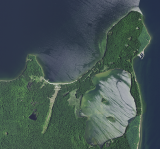
Mackaysee Lake is a lake located in Door County, Wisconsin. The lake is found on Chambers Island in Green Bay of Lake Michigan. Mackaysee Lake has a surface area of 347 acres (1.40 km2) and a max depth of 27 ft (8.2 m). Most of the lake has a sand bottom and is shallow with an average depth of 6 ft (1.8 m). There are two islands in Mackaysee Lake. Both are owned by the Door County Land Trust and are protected in the Chambers Island Nature Preserve. The islands are classified as third order recursive islands due to being in a lake on an island in a lake.


