
The smallmouth bass is a species of freshwater fish in the sunfish family (Centrarchidae) of the order Perciformes. It is the type species of its genus Micropterus, and is a popular game fish sought by anglers throughout the temperate zones of North America, and has been spread by stocking —as well as illegal introductions—to many cool-water tributaries and lakes in Canada and more so introduced in the United States. The maximum recorded size is approximately 27 inches (69 cm) and 12 pounds (5.4 kg).
Long Lake is a town in Hamilton County, New York, United States. The population was 791 at the 2020 census.

Webb is the northernmost town in Herkimer County, New York, United States. As of the 2020 Census it had a population of 1,797.
Watson is a town in Lewis County, New York, United States. The population was 1,802 at the 2020 census. The town is named after early landowner James Watson. The town is at the eastern border of the county and is east of Lowville, the county seat.

Croghan is a town in Lewis County, New York, United States. The population was 3,093 at the 2010 census. The town is in the northern part of the county and located northeast of the county seat, Lowville. The town contains a village also named Croghan, a small part of which is located in the adjacent town of New Bremen. Both the village and town are locally pronounced \Krō-gun\.

The Adirondack Park is a park in northeastern New York protecting the Adirondack Mountains. The park was established in 1892 for "the free use of all the people for their health and pleasure", and for watershed protection. At 6.1 million acres, it is the largest park in the contiguous United States.

The Truckee River is a river in the U.S. states of California and Nevada. The river flows northeasterly and is 121 miles (195 km) long. The Truckee is the sole outlet of Lake Tahoe and drains part of the high Sierra Nevada, emptying into Pyramid Lake in the Great Basin. Its waters are an important source of irrigation along its valley and adjacent valleys.

The Lehigh River is a 109-mile-long (175 km) tributary of the Delaware River in eastern Pennsylvania. The river flows in a generally southward pattern from the Pocono Mountains in Northeastern Pennsylvania through Allentown and much of the Lehigh Valley before joining the Delaware River in Easton.

The Black River is a 125-mile-long (201 km) blackwater river that empties into the eastern end of Lake Ontario on the shore of Jefferson County, New York in the United States. The origin of the name is not clear, but it may stem from the natural tannic acid that darkens the water in places. The river flows in a generally northwest direction, with its valley dividing the Adirondack Mountains on the east from the Tug Hill region to the west.

The Great Sacandaga Lake is a large lake situated in the Adirondack Park in northern New York in the United States. The lake has a surface area of about 41.7 square miles (108 km2) at capacity, and the length is about 29 miles (47 km). The word Sacandaga means "Land of the Waving Grass" in the native Mohawk language. The lake is located in the northern parts of Fulton County and Saratoga County near the southern border of the Adirondack Park. A small portion also extends northward into southern Hamilton County. The broader, south end of the lake is northeast of the City of Johnstown and the City of Gloversville. Great Sacandaga Lake is a reservoir created by damming the Sacandaga River. The primary purpose for the creation of the reservoir was to control flooding on the Hudson River and the Sacandaga River, floods which had a historically significant impact on the surrounding communities.

The Oswegatchie River is a 137-mile-long (220 km) river in northern New York that flows from the Adirondack Mountains north to the Saint Lawrence River. The Oswegatchie River begins at Partlow Lake in Hamilton County, New York. The river continues through Cranberry Lake which was 'doubled in size' through construction of a dam in the late 1860s. The river continues from the dam to Gouverneur, to near Talcville in St. Lawrence County, where it joins the West Branch. Much of it is within Adirondack State Park. The city of Ogdensburg developed at the mouth of the river at its confluence with the St. Lawrence.

The Payette River is an 82.7-mile-long (133.1 km) river in southwestern Idaho and a major tributary of the Snake River.

The Saranac River is an 81-mile-long (130 km) river in the U.S. state of New York.

The Moose River is a mountain waterway in Upstate New York which consists of three branches: the North Branch, the Middle Branch and the South Branch. The outlet of Big Moose Lake forms the North Branch in northern Herkimer County. The Middle Branch originates at the Fulton Chain Lakes in Old Forge. And the Southern Branch has its headwaters in Little Moose Lake in Hamilton County. The North and Middle branches merge in old Forge, New York, then flow a few miles before merging with the South branch, and then becomes just Moose River. It flows generally westwardly through Herkimer County into Lewis County, reaching its confluence with the Black River in Lyons Falls.

Esopus Creek is a 65.4-mile-long (105.3 km) tributary of the Hudson River that drains the east-central Catskill Mountains in the U.S. state of New York. From its source at Winnisook Lake on the slopes of Slide Mountain, the Catskills' highest peak, it flows across Ulster County to the Hudson at Saugerties. Many tributaries extend its watershed into neighboring Greene County and a small portion of Delaware County. Midway along its length, it is impounded at Olive Bridge to create Ashokan Reservoir, the first of several built in the Catskills as part of New York City's water supply system. Its own flow is supplemented 13 miles (21 km) above the reservoir by the Shandaken Tunnel, which carries water from the city's Schoharie Reservoir into the creek.

Lake Nockamixon is a reservoir in southeastern Pennsylvania, United States, and the largest lake in Bucks County. It is formed by a dam on Tohickon Creek and is the centerpiece of Nockamixon State Park. Swimming is not allowed in the lake, but boating is popular. The park maintains a marina and a boat rental as well as three other boat-launch areas.
The Pepperbox Wilderness Area, an Adirondack Park unit of the New York Forest Preserve, lies entirely within the town of Webb in Herkimer County. Stillwater Reservoir and the Beaver River Primitive Area form the southern boundary, while the north bank of the West Branch of the Oswegatchie River generally forms the northern boundary. The western boundary is the county line, and the eastern boundary is the Raven Lake Road and the Five Ponds Wilderness Area.
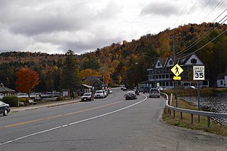
Beaver River is a hamlet that is six-tenths of a mile square, at the east end of Stillwater Reservoir, in the town of Webb in Herkimer County, New York, United States. The hamlet is surrounded by the Adirondack Park. The hamlet has a year-round population of eight that increases during the summer, as many people have camps in this wilderness area. There are 125 private properties and three commercial businesses. No roads lead to the hamlet; it is accessible only by hiking, small self-propelled private track speeder or boat in the summer and by snowmobile, snowshoes or cross country skis in the winter. There is no electrical service. The town is named for the Beaver River, which was impounded to form the Stillwater Reservoir. The Beaver River is a west-flowing tributary of the Black River and part of the Lake Ontario watershed. The former New York Central Railroad right of way, on the National Register of Historic Places, passes through the hamlet; an existing bunkhouse is a part of the historic property. The Adirondack Railroad will resume tourist passenger service from Utica to Tupper Lake, via Beaver River, in 2023: 42 years since the last passenger train ran on its trackage. The last New York Central Railroad passenger train left Beaver River on April 24, 1965.
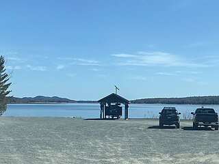
Stillwater Reservoir is a man-made lake located by Beaver River, New York within the Western Adirondacks. The lake has a large amount of recreational uses including camping, canoeing, boating, fishing, hunting, snowmobiling, and cross-country skiing. The lake has undeveloped edges with remote camping on both the islands and the shoreline. Camping permits and lake information may be obtained from the hamlet of Stillwater at the Forest Ranger Headquarters. Fish species present in the reservoir are smallmouth bass, splake, rock bass, yellow perch, sunfish and brown trout. There is a state owned hard surface ramp on Stillwater Road, 28 miles east of Lowville, New York. the record low temperature for the state of New York of −52 °F (−47 °C) took place at Stillwater Reservoir, and was later tied by Old Forge on February 17, 1979.
Soft Maple Reservoir is a reservoir located by Eagle Falls, New York. Fish species present in the lake are tiger muskie, white sucker, pickerel, smallmouth bass, rock bass, yellow perch, and black bullhead. There is a carry down on Soft Maple Road, on the southwest shore.

