The National Road was the first major improved highway in the United States built by the federal government. Built between 1811 and 1837, the 620-mile (1,000 km) road connected the Potomac and Ohio Rivers and was a main transport path to the West for thousands of settlers. When improved in the 1830s, it became the second U.S. road surfaced with the macadam process pioneered by Scotsman John Loudon McAdam.

An Area of Outstanding Natural Beauty is an area of countryside in England, Wales or Northern Ireland that has been designated for conservation due to its significant landscape value. Areas are designated in recognition of their national importance by the relevant public body: Natural England, Natural Resources Wales, or the Northern Ireland Environment Agency. In place of AONB, Scotland uses the similar national scenic area (NSA) designation. Areas of Outstanding Natural Beauty enjoy levels of protection from development similar to those of UK national parks, but unlike national parks the responsible bodies do not have their own planning powers. They also differ from national parks in their more limited opportunities for extensive outdoor recreation.

Canonsburg is a borough in Washington County, Pennsylvania, 18 miles (29 km) southwest of Pittsburgh. Canonsburg was laid out by Colonel John Canon in 1789 and incorporated in 1802. The population was 8,992 at the 2010 census.

Delmont is a borough in Westmoreland County, Pennsylvania, United States. The population was 2,686 at the 2010 census.

Squirrel Hill is a residential neighborhood in the East End of Pittsburgh, Pennsylvania, United States. The city officially divides it into two neighborhoods, Squirrel Hill North and Squirrel Hill South, but it is almost universally treated as a single neighborhood.

Cobblestone is a natural building material based on cobble-sized stones, and is used for pavement roads, streets, and buildings.
Interstate 376 (I-376) is a major auxiliary route of the Interstate Highway System in the U.S. state of Pennsylvania, located within the Allegheny Plateau. It runs from I-80 near Sharon south and east to a junction with the Pennsylvania Turnpike in Monroeville, after having crossed the Pennsylvania Turnpike at an interchange in Big Beaver. The route serves Pittsburgh and its surrounding areas, and is the main access road to Pittsburgh International Airport (PIT). Portions of the route are known as the Beaver Valley Expressway, Southern Expressway, and Airport Parkway. Within Allegheny County, the route runs along the majority of the Penn-Lincoln Parkway, known locally as Parkway West and Parkway East. It is currently the ninth-longest auxiliary Interstate route in the system, and second only to I-476 within Pennsylvania.

Fort Necessity National Battlefield is a National Battlefield Site in Fayette County, Pennsylvania, United States, which preserves the site of the Battle of Fort Necessity. The battle, which took place on July 3, 1754, was an early battle of the French and Indian War, and resulted in the surrender of British colonial forces under Colonel George Washington, to the French and Indians, under Louis Coulon de Villiers.

Allegheny West is a historic neighborhood in Pittsburgh, Pennsylvania's North Side. It has two zip codes of both 15233 and 15212, and has representation on Pittsburgh City Council by the council member for District 1.

White Hall is an unincorporated farming community in northern Frederick County, Virginia, established in the late 1810s and located near the crossroads of Apple Pie Ridge Road with Green Spring and White Hall Roads, astride Apple Pie Ridge.

David B. Oliver High School, commonly known as Oliver High School, was a public school in the Northside area of Pittsburgh, Pennsylvania, United States. Oliver was one of ten high schools in the Pittsburgh Public Schools. The school was closed in 2012 but the building remained open as offices.
Scenery Hill, called Hillsborough before April 10, 1867, is an unincorporated community in North Bethlehem Township in Washington County, Pennsylvania, United States. It serves as the postal address for most North Bethlehem Township residents. The ZIP code is 15360.

Silvermine is an unincorporated community in Fairfield County, Connecticut, United States that extends across three southwestern Connecticut towns: Norwalk, New Canaan and Wilton.
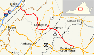
State Route 56 is a primary state highway in the U.S. state of Virginia. The state highway runs 60.87 miles (97.96 km) from U.S. Route 11 at Steeles Tavern east to US 60 near Buckingham. SR 56 is the main east–west highway of Nelson County. The state highway connects the county seat of Lovingston with Buckingham to the east and the Blue Ridge Mountains and the Shenandoah Valley to the west.
Fort Robert Smalls was a Civil War redoubt built by free Blacks for the defense of Pittsburgh in 1863.

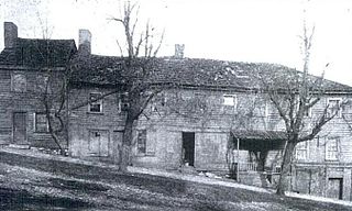
The Brick Tavern House is a former inn on the National Road west of St. Clairsville, Ohio, United States. One of the oldest National Road taverns still in existence, it was built in the early nineteenth century. Although it fell into dilapidation during the late twentieth century, it was named a historic site in 1995, and extensive restoration was to be performed in the early 2010s but to date, has not been.
Scenery Hill Historic District is a historic district in Scenery Hill, Pennsylvania, listed on the National Register of Historic Places in 1996. It is a typical Pike Town along the National Road. Most of the buildings in the district were constructed during the two boom periods of the road, c. 1818 – c. 1853 and c. 1910 – c. 1930. The district contains 93 buildings of many types: taverns, shops, service facilities and residences. Most of the commercial buildings are clustered in the center of the district, east of the National Road intersection with Spring Valley and Fava Farm Roads.
Black Horse Tavern was a historic tavern in Canonsburg, Pennsylvania.

The Old Stone Tavern is a historic building located at 434 Greentree Road, block and number 19-S-156, in the West End Village neighborhood of Pittsburgh, Pennsylvania. The Tavern dates back to at least 1782, and more likely 1777.

Thaddeus Stevens Elementary School located at 824 Crucible Street in the Elliott neighborhood of Pittsburgh, Pennsylvania, was built in 1939. It was a part of Pittsburgh Public Schools and served Elliott, Esplen, Sheraden, West End, and Westgate Village.