
The Halifax and South Western Railway was a historic Canadian railway operating in the province of Nova Scotia.
Highway 103 is an east-west highway in Nova Scotia that runs from Halifax to Yarmouth.

Highway 107 in Nova Scotia runs through the eastern suburbs of the Halifax Regional Municipality, from the Bedford, Nova Scotia-Lower Sackville Border Line off Nova Scotia Highway 107 an intersection with Trunk 7 in Musquodoboit Harbour. It is 52.1 km (32.4 mi) long, and is mostly two lane, controlled access highway.

The Eastern Shore is a region of the Canadian province of Nova Scotia. It is the Atlantic coast running northeast from Halifax Harbour to the eastern end of the peninsula at the Strait of Canso.

Trunk 1 is part of the Canadian province of Nova Scotia's system of Trunk Highways.
Timberlea is a community located within the Municipality of Halifax in Nova Scotia, Canada.

Trunk 2 is part of the Canadian province of Nova Scotia's system of Trunk Highways. The route runs from Halifax to Fort Lawrence on the New Brunswick border. Until the 1960s, Trunk 2 was the Halifax area's most important highway link to other provinces, and was part of a longer Interprovincial Highway 2 which ended in Windsor, Ontario. The controlled access Highway 102 and Highway 104 now carry most arterial traffic in the area, while Trunk 2 serves regional and local traffic.

Nova Scotia Trunk 3 is an east-west trunk highway in Nova Scotia. The route runs from Halifax to Yarmouth, along the South Shore. Trunk 3's status as an important regional highway link has been superseded by the parallel Highway 103.

Bay View High School is a Canadian high school serving the western suburbs of Nova Scotia's Halifax Regional Municipality (HRM); namely the communities of Beechville, Lakeside, Timberlea, Tantallon and communities on the western portion of Highway 333 including Peggy's Cove, Seabright and others. Bay View's feeder schools are Five Bridges Junior High School and Ridgecliff Middle School.
Hubley is a residential community within the Halifax Regional Municipality, Nova Scotia on Trunk 3 between Upper Tantallon and Timberlea approximately 15 kilometres from Halifax.

Halifax Regional Municipality has a multi-modal transportation network.
Beechville is a Black Nova Scotian settlement and suburban community within the Halifax Regional Municipality of Nova Scotia, Canada, on St. Margaret's Bay Road. The Beechville Lakeside Timberlea (BLT) trail starts here near Lovett Lake, following the old Halifax and Southwestern Railway line. Ridgecliff Middle School, located in Beechville Estates, serves the communities of Beechville, Lakeside, and Timberlea.

Bayers Lake Business Park is a business park in Halifax, Nova Scotia west of Clayton Park.
Lakeside is a community within the urban area of the Municipality of Halifax in Nova Scotia.
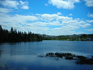
Lovett Lake is a lake in the community of Beechville in the Halifax Regional Municipality, Nova Scotia, Canada. It is located west of the Halifax Peninsula and the crossing of highways 102 and 103 and directly north of St. Margaret's Bay Road. Now the Beechville Lakeville Timberlea (BLT) trail starts directly north-west of the Lake, on the former main route of the historic Halifax and Southwestern Railway, which was near the lake's north shore.
The Old Annapolis Road was a planned direct route between Halifax and Annapolis Royal, the current and former capitals of Nova Scotia, in Eastern Canada. Work began in 1784 and was resumed in 1816 as a military settlement plan for Napoleonic War veterans. Known various times as the Annapolis Military Road, the Dalhousie Road and the Kempt Road, it led to some successful settlements but was never completed and was abandoned in 1829. Some disconnected sections remain in use today.
Paula Anne Gallant was a Canadian school teacher who was murdered by asphyxiation due to strangulation. On December 27, 2005, Gallant and her husband, Jason MacRae were in their basement arguing about a debt from online gambling. After MacRae walked back down to the basement where Gallant was sitting at the computer, he hit her in the back of her head with a two-by-four wood board. He then proceeded to strangle her to the floor until she stopped moving and then wrapped her head with Saran Wrap to make sure she was dead.

The Chain of Lakes Trail is a paved multi-use recreational trail in Halifax, Nova Scotia that runs from Beechville to Fairview. The trail is named for the Chain Lakes along which the trail runs. The trail is part of the Rum Runners trail system, going from Halifax to Lunenburg. They are part of Nova Scotia's Blue Route, a planned 3,000 kilometer cycling trail system.
