
The Mohawk River is a 149-mile-long (240 km) river in the U.S. state of New York. It is the largest tributary of the Hudson River. The Mohawk flows into the Hudson in Cohoes, New York, a few miles north of the state capital of Albany. The river is named for the Mohawk Nation of the Iroquois Confederacy. A major waterway, in the early 19th century, the river's east-west valley provided the setting and water for development of the Erie Canal, as a key to developing New York. The largest tributary, the Schoharie Creek, accounts for over one quarter (26.83%) of the Mohawk River's watershed. Another main tributary is the West Canada Creek, which makes up for 16.33% of the Mohawk's watershed.

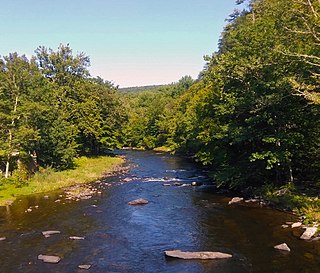
The West Branch Delaware River is one of two branches that form the Delaware River. It is approximately 90 mi (144 km) long, and flows through the U.S. states of New York and Pennsylvania. It winds through a mountainous area of New York in the western Catskill Mountains for most of its course, before joining the East Branch along the northeast border of Pennsylvania with New York. Midway or so it is empounded by the Cannonsville Dam to form the Cannonsville Reservoir, both part of the New York City water supply system for delivering drinking water to the City.
The Neversink River is a 55-mile-long (89 km) tributary of the Delaware River in southeastern New York in the United States. The name of the river comes from the corruption of an Algonquian language phrase meaning "mad river."

Schoharie Creek is a river in New York that flows north 93 miles (150 km) from the foot of Indian Head Mountain in the Catskills through the Schoharie Valley to the Mohawk River. It is twice impounded north of Prattsville to create New York City's Schoharie Reservoir and the Blenheim-Gilboa Power Project.

Wharton Creek is a 36.1-mile-long (58.1 km) tributary of the Unadilla River in western Otsego County, in the state of New York. Via the Unadilla River, it is part of the Susquehanna River watershed, flowing to Chesapeake Bay.

Stony Brook, also known as Stoney Brook, is a tributary of the Millstone River in Hunterdon and Mercer counties, New Jersey, in the United States.

The Cannonsville Reservoir is a reservoir in the New York City water supply system in Delaware County, New York. It was formed by construction of the Cannonsville Dam on its west end, which impounded over half of the West Branch of the Delaware River. Lying on the western part of the Delaware Watershed, it is the westernmost of New York City's reservoirs. It was placed in service in 1964, and is the most recently constructed New York City-owned reservoir.
The Little Androscoggin River is a 51.4-mile-long (82.7 km) river in Maine. It flows from Bryant Pond in Woodstock to its confluence with the Androscoggin River in Auburn. The Androscoggin flows into Merrymeeting Bay in the Kennebec River estuary.
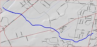
Duck Pond Run is a tributary of the Stony Brook in Mercer County, New Jersey in the United States.
Charlotte Creek is a river located in Delaware County, New York. Charlotte Creek borders the southern border of Otsego County, New York for a few miles near the mouth. The creek converges with the Susquehanna River by Emmons, New York.
Lake Brook is a river in Delaware County, New York. It drains Odell Lake and flows south before converging with the West Branch Delaware River west of Hobart.
Wright Brook is a river in Delaware County, New York. It drains Creamery Pond and flows south before converging with the West Branch Delaware River south of Bloomville.
Falls Creek is a river in Delaware County in the state of New York. It begins east of the hamlet of Meredith and flows in a generally southeast direction before flowing into the West Branch Delaware River north-northeast of the village of Delhi. Watauga Falls is a waterfall located on the creek.
Steele Brook is a river in Delaware County, New York. It flows into the West Branch Delaware River by Delhi. Steele Brook flows through Delhi Reservoir.

Little Delaware River is a river in Delaware County, New York. It begins along the western slope of Plattekill Mountain, northeast of the Hamlet of Bovina and flows generally westward before converging with the West Branch Delaware River by the Village of Delhi.
West Brook flows into the West Branch Delaware River by Walton, New York.
Roods Creek is a river in Delaware County, New York. It begins just south of Cannonsville Reservoir and flows south into Crystal Lake. After exiting Crystal Lake it continues flowing south and then flows into Silver Lake. After exiting Silver Lake it continues southward before converging with the West Branch Delaware River east of the hamlet of Hale Eddy.
Mallory Brook flows into the West Branch Delaware River by Hawleys, New York, United States.
Horse Brook is a river in Delaware County, New York. It drains Lake Mimi and flows south before converging with Beaver Kill northwest of Roscoe.
Beerston is a hamlet in Delaware County, New York. It is located south-southwest of Walton at the corner of NY–10 and Beers Brook Road. Beers Brook converges with the West Branch Delaware River, which flows west through the hamlet.
