
The Rocky Mountains, also known as the Rockies, are a major mountain range in western North America. The Rocky Mountains stretch 3,000 mi (4,800 km) in straight-line distance from the northernmost part of British Columbia, in western Canada, to New Mexico in the Southwestern United States. The northern terminus is located in the Liard River area east of the Pacific Coast Ranges, while the southernmost point is near the Albuquerque area adjacent the Rio Grande Basin and north of the Sandia–Manzano Mountain Range. Located within the North American Cordillera, the Rockies are distinct from the Cascade Range and the Sierra Nevada, which all lie farther to the west.

Norway is a country located in Northern Europe on the northern and western parts of the Scandinavian Peninsula. The majority of the country borders water, including the Skagerrak inlet to the south, the North Sea to the southwest, the North Atlantic Ocean to the west, and the Barents Sea to the north. It has a land border with Sweden to the east and a shorter border with Finland and an even shorter border with Russia to the northeast.

Aconcagua is a mountain in the Principal Cordillera of the Andes mountain range, in Mendoza Province, Argentina. It is the highest mountain in the Americas, the highest outside Asia, and the highest in both the Southern and the Western Hemispheres with a summit elevation of 6,961 metres (22,838 ft). It lies 112 kilometres northwest of the provincial capital, the city of Mendoza, about five kilometres from San Juan Province, and 15 km (9 mi) from Argentina's border with neighbouring Chile. The mountain is one of the so-called Seven Summits of the seven continents.

The Caucasus Mountains are a mountain system at the intersection of Europe and Asia. Stretching between the Black Sea and the Caspian Sea, it is surrounded by the Caucasus region and is home to Mount Elbrus, the highest peak in Europe at 5,642 metres (18,510 ft) above sea level.

The Ural, known as Yaik before 1775, is a river flowing through Russia and Kazakhstan in the continent border between Europe and Asia. It originates in the southern Ural Mountains and discharges into the Caspian Sea. At 2,428 kilometres (1,509 mi), it is the third-longest river in Europe after the Volga and the Danube, and the 18th-longest river in Asia. The Ural is conventionally considered part of the boundary between the continents of Europe and Asia.

A mountain pass is a navigable route through a mountain range or over a ridge. Since many of the world's mountain ranges have presented formidable barriers to travel, passes have played a key role in trade, war, and both human and animal migration throughout history. At lower elevations it may be called a hill pass.

Sabalan is an inactive stratovolcano in the Lesser Caucasus mountain range and Ardabil Province of northwestern Iran.

A summit is a point on a surface that is higher in elevation than all points immediately adjacent to it. The topographic terms acme, apex, peak, and zenith are synonymous.

European highway E 134 is a European highway that crosses Norway starting at Haugesund Airport, Karmøy near the city of Haugesund on the west coast, heading over Haukeli, passing the city of Drammen, and ending in Vassum on the east side of the Oslofjord Tunnel.
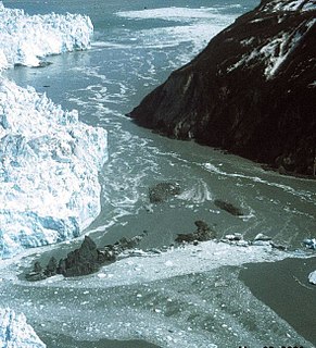
A glacial lake outburst flood (GLOF) is a type of outburst flood caused by the failure of a dam containing a glacial lake. An event similar to a GLOF, where a body of water contained by a glacier melts or overflows the glacier, is called a jökulhlaup. The dam can consist of glacier ice or a terminal moraine. Failure can happen due to erosion, a buildup of water pressure, an avalanche of rock or heavy snow, an earthquake or cryoseism, volcanic eruptions under the ice, or massive displacement of water in a glacial lake when a large portion of an adjacent glacier collapses into it.
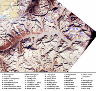
The Baltoro Muztagh is a subrange of the Karakoram mountain range, in Baltistan region of the Gilgit-Baltistan, northernmost political entity of Pakistan; and in Xinjiang, China. The crest of the range forms part of the Pakistan-China border.
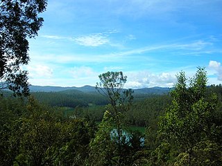
The Nilgiri Mountains form part of the Western Ghats in western Tamil Nadu, India. At least 24 of the Nilgiri Mountains' peaks are above 2,000 metres (6,600 ft), the highest peak being Doddabetta, at 2,637 metres (8,652 ft).

Saddleback Mountain is a mountain near Kiama in the Illawarra region of New South Wales, Australia. The mountain rises to about 600 metres (2,000 ft) above sea level on the Illawarra escarpment and has views of Noorinan Mountain, 662 metres (2,172 ft) above sea level, and Barren Grounds Plateau to the west and south to Coolangatta Mountain and Pigeon House Mountain to Ulladulla, and north over Lake Illawarra, the Illawarra escarpment and to the Cronulla Sandhills and Kurnell Oil Refinery on a clear day.

An ultra-prominent peak, or Ultra for short, is a mountain summit with a topographic prominence of 1,500 metres (4,900 ft) or more; it is also called a P1500. The prominence of a peak is the minimum height of climb to the summit on any route from a higher peak, or from sea level if there is no higher peak. There are approximately 1,524 such peaks on Earth. Some well-known peaks, such as the Matterhorn and Eiger, are not Ultras because they are connected to higher mountains by high cols and therefore do not achieve enough topographic prominence.

The topographic isolation of a summit is the minimum distance to a point of equal elevation, representing a radius of dominance in which the peak is the highest point. It can be calculated for small hills and islands as well as for major mountain peaks, and can even be calculated for submarine summits.

The Mount Royal Range is a mountain range in the Hunter region of New South Wales, Australia.

Grevillea oxyantha is a plant from the Protea family, found in the cold mountain regions of southern New South Wales, Australia. The species grows from one to three metres in height. They are often found on rocky places, near cliffs or occasionally near streams. Rock types are mostly granite or quartzite. Nearby localities include Wee Jasper, Tumut, Batlow and Brown Mountain.

The Siffleur Wilderness Area is a provincially designated wilderness area in the Canadian Rockies of Alberta. It was established in 1961 and it, as one of the three wilderness areas of Alberta, has the strictest form of government protection available in Canada. All development is forbidden and only travel by foot is permitted. Hunting and fishing are not allowed. The other two wilderness areas are White Goat Wilderness Area and Ghost River Wilderness Area and together the three areas total 249,548.80 acres (100,988.82 ha).


