Ardnamurchan is a 50-square-mile (130-square-kilometre) peninsula in the ward management area of Lochaber, Highland, Scotland, noted for being very unspoiled and undisturbed. Its remoteness is accentuated by the main access route being a single track road for much of its length. The most westerly point of mainland Great Britain, Corrachadh Mòr, is in Ardnamurchan.

Beinn Alligin is one of the classic mountains of the Torridon region of Scotland, lying to the north of Loch Torridon, in the Highlands. The name Beinn Alligin is from the Scottish Gaelic, meaning Jewelled Hill. The mountain has two peaks of Munro status: Tom na Gruagaich to the south, and Sgùrr Mhòr at 986 metres (3,235 ft) to the north.
Beinn Eighe is a complex mountain massif in the Torridon area of Wester Ross in the Highlands of Scotland. Lying to the south of Loch Maree, it forms a long ridge with many spurs and summits, two of which are classified as Munros. The name Beinn Eighe comes from the Scottish Gaelic meaning file mountain. Unlike most other hills in the area it has a cap of Cambrian basal quartzite which gives the peaks of Beinn Eighe a distinctive light colour. Its complex topography has made it popular with both hillwalkers and climbers and the national nature reserve on its northern side makes it an accessible mountain for all visitors.

Ballochroy is a megalithic site in Kintyre on the Argyll peninsula in Scotland. It consists of three vertical stones, side by side, aligned with various land features 7–19 miles (11–31 km) away.

The Oa is a rocky peninsula in the southwest of the island of Islay, in Argyll, Scotland. It is an RSPB nature reserve.

Beinn an Òir is the highest peak of the Paps of Jura on the island of Jura, Scotland. It is the highest peak on the island, standing at 785 metres, and is thereby a Corbett.

Beinn Shiantaidh is the second highest peak of the Paps of Jura on the island of Jura, Scotland. It stands at 757 metres above sea level, and with over 300 metres of relative height is therefore a Graham.
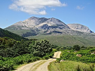
The Paps of Jura are three mountains on the western side of the island of Jura, in the Inner Hebrides of Scotland. Their highest point is 2,575 feet (785 m).

Scotland is the most mountainous country in the United Kingdom, featuring 282 peaks exceeding 3,000 feet (914 m), 10 of those are over 4,000 feet (1,219 m), with the highest and most notable being Ben Nevis 4,413 feet (1,345 m) above sea level. Its mountain ranges can be divided, in a roughly north to south direction, into: the Scottish Highlands, the Central Belt and the Southern Uplands, the latter two primarily belonging to the Scottish Lowlands. The highlands contains the country's main mountain ranges, but many hills and mountains are to be found south of these as well. The highlands includes Britain's loftiest peaks, the Munros, the highest being Ben Nevis at 1,344.53 m. The below lists are not exhaustive; there are countless subranges throughout the country.
Ben Venue is a mountain in the Trossachs area of Scotland. The name Ben Venue is derived from the Scottish Gaelic words meaning "the miniature mountain". The summit lies approximately 2 kilometres south-west of the pier at the southern end of Loch Katrine. At the foot of the mountain close to the shore of Loch Katrine is Bealach nam Bò meaning the "pass of the cattle", a reference to the lawless days when Highland cattle "lifters" used the pass to drive stolen herds to their land.
Glenachulish is a hamlet and glen which lie close to the village of Ballachulish in the Scottish Highlands.
Sgorr Ruadh is a mountain situated in the mountainous area between Strath Carron and Glen Torridon in Wester Ross in the Highland Region of Scotland. It is located in Coire Lair near Achnashellach along with two other fine mountains, Beinn Liath Mhòr and Fuar Tholl, and is often climbed in conjunction with one or both of these other mountains.

Beinn a' Chroin is a Scottish mountain located six kilometres south of Crianlarich in the Stirling Council area. With a height of 941.4 metres it qualifies as a Munro.

Beinn Sgritheall is the highest mountain in the Glenelg area of the Highlands of Scotland. The main approach is via Arnisdale on the shores of Loch Hourn or via Gleann Beag to the north, with its well-known brochs. The view from the summit was described by Sir Hugh Munro, a founder member of the Scottish Mountaineering Club, as "perhaps the most beautiful I have seen in Scotland".

Beinn Mhòr is the highest mountain on the Cowal Peninsula west of Loch Eck in Argyll and Bute, Scotland. It has a high topographic prominence to height ratio and consequently commands a good all round view.

Ben Bhuidhe is a Scottish mountain at the head of Loch Fyne, Argyll and Bute.

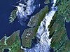
Jura is an island in the Inner Hebrides of Scotland, adjacent to and northeast of Islay. With an area of 36,692 hectares (142 sq mi), and 196 inhabitants recorded in the 2011 census, Jura is more sparsely populated than Islay, and is one of the least densely populated islands of Scotland: in a list of the islands of Scotland ranked by size, Jura comes eighth, whereas by population it comes 31st. The island is mountainous, bare and largely infertile, covered by extensive areas of blanket bog.

Loch Sunart is a sea loch on the west coast of Scotland. Loch Sunart is bounded to the north by the Sunart district of Ardnamurchan and to the south by the Morvern district. At 31 kilometres (19 mi) long, it is the longest sea loch in the Highland local government area. The maximum depth of the loch is 124 metres, east of Càrna and near the entrance to Loch Teacuis. Other islands in the loch include Oronsay, seaward of Càrna, Risga, which lies between the two larger islands, and Eilean Mòr, which lies towards the landward end of the loch in line with Beinn Resipol.

The Maiden Paps are twin hills near Hawick, in the Scottish Borders of the south east of Scotland, that have the shape of human breasts. They are located 12 kilometres (7.5 mi) south of Hawick; the higher pap is 510 metres (1,670 ft) and the lower 500 metres (1,600 ft) high.
Beinn Bhreac is a name shared by a number of Scottish hills and mountains: