
Sir John Betjeman was an English poet, writer, and broadcaster. He was Poet Laureate from 1972 until his death. He was a founding member of The Victorian Society and a passionate defender of Victorian architecture, helping to save St Pancras railway station from demolition. He began his career as a journalist and ended it as one of the most popular British Poets Laureate and a much-loved figure on British television.

Thame is a market town and civil parish in Oxfordshire, about 13 miles (21 km) east of the city of Oxford and 10 miles (16 km) southwest of Aylesbury. It derives its name from the River Thame which flows along the north side of the town and forms part of the county border with Buckinghamshire. The parish includes the hamlet of Moreton south of the town. The 2011 Census recorded the parish's population as 11,561. Thame was founded in the Anglo-Saxon era and was in the kingdom of Wessex.

Oxford Instruments plc is a United Kingdom manufacturing and research company that designs and manufactures tools and systems for industry and research. The company is headquartered in Abingdon, Oxfordshire, England, with sites in the United Kingdom, United States, Europe, and Asia. It is listed on the London Stock Exchange and is a constituent of the FTSE 250 Index.
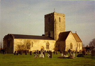
Uffington is a village and civil parish in Oxfordshire, about 4 miles (6.4 km) south of Faringdon and 6 miles (10 km) west of Wantage. The 2011 Census recorded the parish's population as 783. It was originally in the county of Berkshire, but under the Local Government Act 1972 it was transferred for local government purposes to Oxfordshire. The Uffington White Horse hill figure is on the Berkshire Downs on the south side of the parish. The village has been twinned with Le Chevain in France since 1991.
Cholsey is a village and civil parish 2 miles (3 km) south of Wallingford in South Oxfordshire. In 1974 it was transferred from Berkshire to Oxfordshire, and from Wallingford Rural District to the district of South Oxfordshire. The 2011 Census recorded Cholsey's parish population as 3,457. Cholsey's parish boundaries, some 17 miles (27 km) long, reach from the edge of Wallingford into the Berkshire Downs. The village green is called "The Forty" and has a substantial and ancient walnut tree.

Islip is a village and civil parish on the River Ray, just above its confluence with the River Cherwell in Oxfordshire, England. It is about 2 miles (3 km) east of Kidlington and about 5 miles (8 km) north of Oxford. The 2011 Census recorded the parish's population as 652.
Cutteslowe is a suburb of north Oxford, England, between Sunnymead and Water Eaton.

Sir Francis Simon, was a German and later British physical chemist and physicist who devised the gaseous diffusion method, and confirmed its feasibility, of separating the isotope Uranium-235 and thus made a major contribution to the creation of the atomic bomb.

Broad Street is a wide street in central Oxford, England, just north of the former city wall. The street is known for its bookshops, including the original Blackwell's bookshop at number 50, located here due to the University of Oxford. Among residents, the street is traditionally known as The Broad.

Banbury Road is a major arterial road in Oxford, England, running from St Giles' at the south end, north towards Banbury through the leafy suburb of North Oxford and Summertown, with its local shopping centre. Parallel and to the west is the Woodstock Road, which it meets at the junction with St Giles'. To the north, Banbury Road meets the Oxford Ring Road at a roundabout. The road is designated the A4165. Prior to the building of the M40 motorway extension in 1990, the road formed part of the A423 from Maidenhead to Coventry.

Linton Road is a road in North Oxford, England.

Northmoor Road is a residential street in North Oxford, England.

Charlbury Road is a road in North Oxford, England, running to the east of and parallel with the Banbury Road.
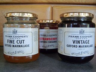
Frank Cooper's is a UK brand of marmalades and jams owned by Hain Daniels. Frank Cooper's is known primarily for its "Oxford" Marmalade and holds a Royal Warrant.

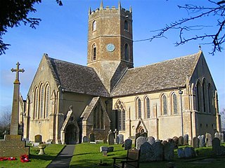
Chesterton is a village and civil parish on Gagle Brook, a tributary of the Langford Brook in north Oxfordshire. The village is about 1+1⁄2 miles (2.4 km) southwest of the market town of Bicester. The village has sometimes been called Great Chesterton to distinguish it from the hamlet of Little Chesterton, about 3⁄4 mile (1.2 km) to the south in the same parish. The 2011 Census recorded the parish population as 850.

Lathbury Road is a short residential road in north Oxford, England.

Rawlinson Road is a residential road in North Oxford, England.

Staverton Road is a residential road in North Oxford, England.
Garford Road is a residential road in North Oxford, England.

Bradmore Road is a residential road in North Oxford, England.
