Related Research Articles

Sudbury is a market town and civil parish in the south west of Suffolk, England, on the River Stour near the Essex border, 60 miles (97 km) north-east of London. It is the largest town in the Babergh local government district and part of the South Suffolk constituency. In 2021 the built-up area had a population of 23,912 and the parish had a population of 13,619.

Babergh District is a local government district in Suffolk, England. In 2021 it had a population of 92,300. The district is primarily a rural area, containing just two towns, Sudbury and Hadleigh, which was the administrative centre until 2017 when the council moved to shared offices with neighbouring Mid Suffolk District Council in Ipswich, outside either district. The district is named after the medieval Babergh Hundred, which covered part of the area.
West Suffolk was an administrative county of England created in 1889 from part of the county of Suffolk. It survived until 1974 when it was rejoined with East Suffolk. Its county town was Bury St Edmunds.

Saffron Walden was a constituency in Essex, represented in the House of Commons of the UK Parliament from 1922 to 2024 by members of the Conservative Party.

Bury St Edmunds was a constituency in Suffolk from 1621 to 2024, most recently represented in the House of Commons of the UK Parliament from 2015 to 2024 by Jo Churchill, a Conservative.

South Suffolk is a constituency represented in the House of Commons of the UK Parliament since 2015 by James Cartlidge, a Conservative.

Melford Rural District was a rural district in the county of West Suffolk, England. It was created in 1894, under the Local Government Act 1894 from that part of the Sudbury rural sanitary district in West Suffolk. It was named after Long Melford and administered from Sudbury. Shortly after its creation, in 1896, the parish of Glemsford was made a separate urban district.

Belchamp Otten is a village and civil parish in Essex, England. It is located approximately 4.3 miles (7 km) west of Sudbury, Suffolk, and is 23 miles (37 km) north-northeast of the county town of Chelmsford. It is near Belchamp St Paul and Belchamp Walter. The village is in the district of Braintree and in the parliamentary constituency of Braintree. The parish is part of the Stour Valley North parish cluster

Belchamp Walter is a village and civil parish in Essex, England. It is located approximately 5 km (3.1 mi) west of Sudbury, Suffolk and is 35 km north-northeast from the county town of Chelmsford. It is near Belchamp St Paul and Belchamp Otten. The village is in the district of Braintree and in the parliamentary constituency of Braintree. The parish is part of the Stour Valley South parish cluster and has a population of 198.
Halstead was a rural district in Essex, England from 1894 to 1974. It was created by the Local Government Act 1894 as a successor to the Halstead rural sanitary district.
Bumpstead was a rural district in the administrative county of Essex, England from 1894 to 1934.

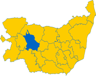
Thedwastre was a rural district in West Suffolk, England from 1894 to 1974. Thedwastre was formed under the Local Government Act 1894, from the part of the Stow Rural Sanitary District which was in West Suffolk. It was named after the historic hundred of Thedwastre.
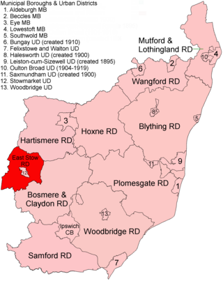
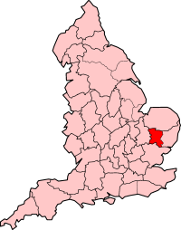
East Stow was a rural district in East Suffolk, England from 1894 to 1934.

Belchamp St Paul is a village and civil parish in the Braintree district of Essex, England.
Thedwastre was a hundred of the county of Suffolk, England covering an area of 40,362 acres (163.34 km2). It formed part of the Liberty of Saint Edmund, under the jurisdiction of the abbots of Bury St Edmunds.

Gestingthorpe is a village and a civil parish in the Braintree district, in the English county of Essex. It is approximately halfway between the towns of Halstead in Essex and Sudbury in Suffolk. The nearest railway station is in Sudbury, which offers a shuttle service to Marks Tey and at the extremes of the day to Colchester. The village is situated at a set of crossroads, North End Road, Nether Hill, Sudbury Road and Church Street.

Great Henny is a village and civil parish in the Braintree district in the county of Essex, England. Nearby settlements include the villages of Little Henny and Twinstead and the Suffolk market town of Sudbury. The hamlet of Henny Street, within the parish, is on the River Stour which forms the parish's eastern border. It shares a parish council with Little Henny and Twinstead called "Hennys', Middleton & Twinstead".

Little Henny is a hamlet and civil parish in the Braintree district in the county of Essex, England. It shares a parish council with Great Henny and Twinstead called "Hennys', Middleton & Twinstead". It is near the town of Sudbury in Suffolk. In 2001 the parish had a population of 48.

The Hinckford Hundred was one of the 19 historic Hundreds of Essex, covering an area of approximately 110566 acres it lies to the north of Essex occupying most of what is now Braintree district.

Knowl Green is a hamlet in the civil parish of Belchamp St Paul and the Braintree district of Essex, England.