Middleton, Essex

Last updated

Middleton
All Saints, Middleton, Essex - geograph.org.uk - 334939.jpg
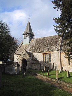
All Saints' Church, Middleton
Essex UK location map.svg
Red pog.svg
Middleton
Middleton shown within Essex
OS grid reference TL870395
District
Shire county
Region
Country England
Sovereign state United Kingdom
Post town SUDBURY
Postcode district CO10
Police Essex
Fire Essex
Ambulance East of England
EU Parliament East of England
List of places
UK
England
Essex
Coordinates: 52°01′22″N0°43′36″E / 52.02266°N 0.72664°E / 52.02266; 0.72664

Middleton is a village and civil parish in the Braintree District of Essex, England. The village is 1 mile (1.6 km) south from the Ballingdon suburb of the market town of Sudbury. The parish, which is 2 miles (3.2 km) east to west and less than 1 mile north to south, is bordered at the north and east by the county of Suffolk, at the west by the Essex parish of Bulmer and the A131 road, and at the south by the Essex parishes of Little Henny and Great Henny. The River Stour also forms the eastern border.

Civil parish territorial designation and lowest tier of local government in England, UK

In England, a civil parish is a type of administrative parish used for local government, they are a territorial designation which is the lowest tier of local government below districts and counties, or their combined form, the unitary authority. Civil parishes can trace their origin to the ancient system of ecclesiastical parishes which historically played a role in both civil and ecclesiastical administration; civil and religious parishes were formally split into two types in the 19th century and are now entirely separate. The unit was devised and rolled out across England in the 1860s.

Braintree District Non-metropolitan district in England

Braintree is a local government district in the English county of Essex, with a population of 147,084. Its main town is Braintree.

Essex County of England

Essex is a county in the south-east of England, north-east of London. One of the home counties, it borders Suffolk and Cambridgeshire to the north, Hertfordshire to the west, Kent across the estuary of the River Thames to the south, and London to the south-west. The county town is Chelmsford, the only city in the county. For government statistical purposes Essex is placed in the East of England region.

In the north of the parish at Middleton Hall Farm is small light industrial and services park which includes a vehicle sales company and the headquarters of a turkey farm. This was the only farm and only trade listed in 1882 and 1914. By 1894 a carpenter was trading, and in 1902, a baker. The parish contained a mixed National School for 40 children, built in 1875. This had become a Public Elementary School by 1914. [1] Earlier, in 1818, the parish population of 90 had no school. [2]

National school (England and Wales)

A National school was a school founded in 19th century England and Wales by the National Society for Promoting Religious Education. These schools provided elementary education, in accordance with the teaching of the Church of England, to the children of the poor. Together with the less numerous British schools of the British and Foreign School Society, they provided the first near-universal system of elementary education in England and Wales.

Elementary schools were the first schools in England which were funded by taxation. They operated between 1870 and 1944 and provided an education for children between the ages of 5 and 14. In some areas older children were educated in separate 'Higher Elementary Schools', which were ruled un-permissible by the Cockerton Judgement 1899 and regularised by the 1902 Education Act. Many of these schools converted to Primary schools after 1944.

At the end of the 19th-century parish area varied from 868 acres (3.5 km2) to 890 acres (3.6 km2). Parish soil was of clay, loam and gravel, on which was grown wheat, barley, beans and turnips. Between 1881 and 1911, the population dropped from 165 to 133. [1]

The Parish Church of All Saints', which dates to the mid-12th century, is a Grade I listed building. Within the church chancel is a 14th-century Purbeck marble figurative floor slab to the memory of a rector of Middleton, died 1349. The parish register dates to 1700. The church seats 150. All Saints' Church was restored in the 19th century, when the bell turret and south porch were rebuilt, a vestry added to the north, and an organ chamber installed. The living at the time was a rectory with a residence and 40 acres (0.2 km2) of glebe land used for the support of the parish priest and church. In 1882 an oil-on-canvas painting of the Annunciation was reported to be above All Saints' chancel arch, which might have been the work of the 16th-century artist Andrea Schiavone. The rectory house was noted between 1882 and 1902, but not in 1914, as "beautifully situated with a small park in front and contains a splendid collection of oil and water colour paintings by English, Dutch, Flemish, French and Italian masters". [1] [3] [4] [5]

Church of England parish church church which acts as the religious centre for the people within the smallest and most basic Church of England administrative region

A parish church in the Church of England is the church which acts as the religious centre for the people within the smallest and most basic Church of England administrative region, the parish – since the 19th century called the ecclesiastical parish to avoid confusion with the civil parish which many towns and villages have.

Listed building Collection of protected architectural creations in the United Kingdom

A listed building, or listed structure, is one that has been placed on one of the four statutory lists maintained by Historic England in England, Historic Environment Scotland in Scotland, Cadw in Wales, and the Northern Ireland Environment Agency in Northern Ireland.

A vestry was a committee for the local secular and ecclesiastical government for a parish in England and Wales, which originally met in the vestry or sacristy of the parish church, and consequently became known colloquially as the "vestry".

At the centre of Middleton Hall Farm is Middleton Hall, built in 1864 but today unlisted; it is part surrounded by a mutilated rectangular moat as a listed monument. [6]

A Grade II listed thatched two-storey cottage dating to the 17th century is 250 yards (229 m) southeast from the church on a minor road to Henny Street. [7] South from the church by 60 yards (55 m), and with access from Rectory Road is Queens Beeches, a Grade II listed early 19th-century grey brick house with attached stables and carriage house. [8]

Henny Street hamlet in Great Henny, Braintree, Essex, England

Henny Street is a hamlet in the civil parish of Great Henny and the Braintree district of Essex, England. The hamlet is on Henny Road at the east of the parish and adjacent to the west bank of the River Stour.

Related Research Articles

Sausthorpe village in Lincolnshire

Sausthorpe is a small village and civil parish in the East Lindsey district of Lincolnshire, England. It is situated 8 miles (13 km) east from Horncastle and 3 miles (4.8 km) north-west from Spilsby. Sausthorpe is within the Lincolnshire Wolds valley of the River Lymn, and on the southern edge of the Lincolnshire Wolds Area of Outstanding Natural Beauty.

Howell, Lincolnshire village in United Kingdom

Howell is a hamlet in the North Kesteven district of Lincolnshire, approximately 1 mile (1.6 km) north of the A17, 4 miles (6 km) east from Sleaford, and 1.5 miles (2.4 km) north from Heckington. It is in the civil parish of Asgarby and Howell.

Wyberton village in Lincolnshire, England

Wyberton is a village in Lincolnshire, England. It lies just south-west of Boston, and on the B1397 – the former A16 London Road – between Boston and Kirton. The A16 along the former East Lincolnshire railway line bisects the village. The population of the civil parish at the 2011 census was 3,747.

Middleton Stoney village and civil parish in Cherwell district, Oxfordshire, England

Middleton Stoney is a village and civil parish about 2 12 miles (4 km) west of Bicester, Oxfordshire. The 2011 Census recorded the parish's population as 331.

Stanford Rivers village in United Kingdom

Stanford Rivers is a village and civil parish in the Epping Forest district of Essex, England. The parish, which is approximately 11 miles (18 km) east from the county town of Chelmsford, contains the village of Toot Hill and the hamlet of Little End, both settlements larger than Stanford Rivers village, and the hamlet of Clatterford End. The village is 2.0 miles (3 km) south-east of Chipping Ongar, 3 miles (5 km) south-west of North Weald Bassett and 3 miles north-west of Kelvedon Hatch. The parish covers an area of 1,749 hectares.

Heydour village in Lincolnshire

Heydour is a hamlet and civil parish in the South Kesteven district of Lincolnshire, England. The population of the civil parish was 286 at the 2001 census and increased to 311 at the 2011 census. Heydour lies about 5 miles (8 km) south-west of Sleaford and 6 miles (10 km) north-east of Grantham. It forms a close group of parish hamlets with Kelby, Culverthorpe, Oasby and Aisby.

Merther hamlet and former civil parish in St Michael Penkevil, Cornwall, England

Merther is a small hamlet 2 miles (3 km) east of Truro in Cornwall, England. It lies on the eastern side of the Tresillian River in the civil parish of St Michael Penkevil. It was formerly the churchtown of the small parish of Merther, and also the site of a manor house and medieval chapel dedicated to St Cohan. The former parish church is now in ruins.

White Roding village and civil parish in Essex, England

White Roding is a village and civil parish in the Uttlesford district of Essex, England. The village is included in the eight hamlets and villages called The Rodings. White Roding is 8 miles (13 km) north-west from the county town of Chelmsford.

Margaret Roding human settlement

Margaret Roding is a village and civil parish in the Uttlesford district of Essex, England. The village is included in the eight hamlets and villages called The Rodings. Margaret Roding is 7 miles (11 km) north-west from the county town of Chelmsford.

Leaden Roding human settlement in United Kingdom

Leaden Roding is a village and civil parish in the Uttlesford district of Essex, England. The village is included in the eight hamlets and villages called The Rodings. Leaden Roding is 8 miles (13 km) north-west from the county town of Chelmsford.

Westwell, Oxfordshire village and civil parish in West Oxfordshire, Oxfordshire, England

Westwell is a village and civil parish about 2 miles (3 km) southwest of Burford in Oxfordshire.

Good Easter Village in United Kingdom

Good Easter is a village and civil parish in the Chelmsford district of Essex, England. The village is 6 miles (10 km) northwest from the city and county town of Chelmsford. The parish includes the hamlets of Farmbridge End at the south, and Tye Green, conjoined to Good Easter village. The A1060 road is part of the southern boundary of the parish.

Shelley, Essex human settlement in United Kingdom

Shelley is a partly rural village and partly residential conurbation in the Ongar civil parish of the Epping Forest District of Essex, England.

Saxby All Saints human settlement in United Kingdom

Saxby All Saints is a village and civil parish in North Lincolnshire, England. The population of the civil parish at the 2011 census was 385. It is 6 miles (9.7 km) north of Brigg and 4 miles (6.4 km) south-west of Barton upon Humber.

Littley Green human settlement in United Kingdom

Littley Green is a hamlet in the civil parish of Great Waltham, and the Chelmsford borough of Essex, England. The hamlet is at the extreme north of Great Waltham, with the nearest settlement the hamlet of Hartford End, less than 1 mile west in the civil parish of Felsted.

High Roding village and civil parish in Essex, England

High Roding is a village and civil parish in the Uttlesford district of Essex, England. The village is included in the eight hamlets and villages called The Rodings. High Roding is 9 miles (14 km) northwest from the county town of Chelmsford.

Newmans End hamlet in Matching, Epping Forest, Essex, England

Newman's End is a hamlet in the civil parish of Matching, and the Epping Forest district of Essex, England.

Coopersale human settlement in United Kingdom

Coopersale, also termed Coopersale Common, is a village in the civil parish of Epping, within the Epping Forest District of Essex, England.

Dormington human settlement in the United Kingdom

Dormington is a village and civil parish in Herefordshire, in the West Midlands of England. Dormington village is at the north of its parish, 5 miles (8 km) east from the centre of the city and county town of Hereford, and 8 miles (13 km) west-northwest from the town of Ledbury. The parish is a significant traditional centre for hop growing.

References

  1. 1 2 3 Kelly's Directory of Essex 1882 p.211 / 1894 pp.250,251 / 1902 p.299 / 1914 p.435
  2. Digest of Parochial Returns, House of Commons Select Committee on Education of the Poor (1818)
  3. Historic England. "Church of All Saints' (1123271)". National Heritage List for England . Retrieved 4 March 2018.
  4. Historic England. "Church of All Saints (1577070)". PastScape. Retrieved 4 March 2018.
  5. "Middleton", in An Inventory of the Historical Monuments in Essex, vol 3, North East (London, 1922), pp. 181-183. British History Online. Retrieved 4 March 2018
  6. Historic England. "Middleton Hall (382029)". PastScape. Retrieved 4 March 2018.
  7. Historic England. "Thatched cottage (1169846)". National Heritage List for England. Retrieved 4 March 2018.
  8. Historic England. "Queens Beeches (1169855)". National Heritage List for England. Retrieved 4 March 2018.