
Fundulea is an agricultural town in Călărași County, Muntenia, Romania. It is on the Bărăgan Plain, approximately 30 km east of the capital Bucharest, in the historical region of Wallachia. It has a population of 6,217. The A2 freeway and Mostiștea River pass through its vicinity. Two villages are administered by the town: Alexandru Ioan Cuza and Gostilele. It officially became a town in 1989, as a result of the Romanian rural systematization program.

The Aiud or Aiudul de Sus is a left tributary of the river Mureș in Transylvania, Romania. It discharges into the Mureș in Aiud. The upper reach is also known as Siloș. Its length is 27 km (17 mi) and its basin size is 182 km2 (70 sq mi).

The Argova is a left tributary of the river Mostiștea in Romania. It flows into the Mostiștea in Curătești. Its length is 23 km (14 mi).
The Ghimbășel is a left tributary of the river Bârsa in Romania. Its source is in the northern part of the Bucegi Mountains. Originally it discharged directly into the Olt, but much of its flow has been diverted into the Bârsa, another tributary of the Olt, near Colonia Bod. Its length is 67 km (42 mi) and its basin size is 533 km2 (206 sq mi). The former lower course of the Ghimbășel, downstream of this diversion, still exists and is used for the discharge of local inflows. It flows into the Olt north of Bod. Its length is 6 km (3.7 mi) and its basin size is 8 km2 (3.1 sq mi).

The Geoagiu is a right tributary of the river Mureș in Transylvania, Romania. It discharges into the Mureș in Teiuș. Its length is 49 km (30 mi) and its basin size is 187 km2 (72 sq mi).
The Cladova is a right tributary of the river Mureș in Romania. It discharges into the Mureș near Radna. Its length is 16 km (9.9 mi) and its basin size is 71 km2 (27 sq mi).
The Petriș is a right tributary of the river Mureș in Romania. It discharges into the Mureș in Seliște. Its length is 14 km (8.7 mi) and its basin size is 111 km2 (43 sq mi).
The Homorod is a right tributary of the river Mureș in Romania. It discharges into the Mureș near Geoagiu. Its length is 14 km (8.7 mi) and its basin size is 33 km2 (13 sq mi).
The Turdaș is a left tributary of the river Mureș in Romania. It discharges into the Mureș in the village Turdaș. Its length is 14 km (8.7 mi) and its basin size is 65 km2 (25 sq mi).
The Bistra is a right tributary of the river Mureș in Transylvania, Romania. It discharges into the Mureș in Bistra Mureșului. Its length is 26 km (16 mi) and its basin size is 116 km2 (45 sq mi).
The Sebeș is a river in the Gurghiu Mountains, Mureș County, northern Romania. It is a left tributary of the river Mureș. It flows through the commune of Rușii-Munți, and joins the Mureș in the village Sebeș. Its length is 11 km (6.8 mi) and its basin size is 30 km2 (12 sq mi).
The Sălard is a small river in the Gurghiu Mountains, Mureș County, northern Romania. It is a left tributary of the river Mureș. It flows through the municipality Lunca Bradului, and joins the Mureș in the village Sălard. It is fed by several smaller streams, including the Pârâul Rece and Jirca. Its length is 18 km (11 mi) and its basin size is 126 km2 (49 sq mi).
The Somonița is a left tributary of the river Mureș in Romania. It discharges into the Mureș in Valea Mare. Its length is 20 km (12 mi) and its basin size is 64 km2 (25 sq mi).
The Borzontul Mare is a left tributary of the river Mureș in Romania. It discharges into the Mureș near Joseni. The upper reach of the river is also known as Putna. Its length is 15 km (9.3 mi) and its basin size is 46 km2 (18 sq mi).
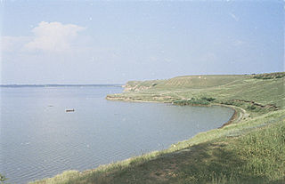
The Mostiștea is a left tributary of the river Danube in Romania. It flows through the artificial Lake Mostiștea. Its source is near the village Dascălu, northeast of Bucharest. It flows into the Danube near Mânăstirea. Its length is 98 km (61 mi) and its basin size is 1,758 km2 (679 sq mi).
The Corâta is a right tributary of the river Mostiștea in Romania. It flows into the Mostiștea near Codreni. Its length is 12 km (7.5 mi) and its basin size is 89 km2 (34 sq mi).
The Ilva is a right tributary of the river Mureș in Transylvania, Romania. It discharges into the Mureș in Lunca Bradului. Its length is 23 km (14 mi) and its basin size is 126 km2 (49 sq mi).
The Almaș is a right tributary of the river Mureș in Romania. It discharges into the Mureș near Zam. Its length is 18 km (11 mi) and its basin size is 86 km2 (33 sq mi).
The Cuieșd is a right tributary of the river Mureș in Transylvania, Romania. It discharges into the Mureș in Cristești. Its length is 13 km (8.1 mi) and its basin size is 56 km2 (22 sq mi). Its name originates from the Hungarian “kő” for “stone”, so its name means “Stony Creek”.
The Colceag is a left tributary of the river Mostiștea in Romania. It flows into the Mostiștea in Măriuța. Its length is 33 km (21 mi) and its basin size is 211 km2 (81 sq mi).
