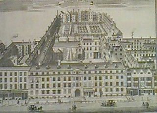
Holborn, an area in central London, covers the south-eastern part of the London Borough of Camden and a part of the Ward of Farringdon Without in the City of London.

Whitechapel is an area in London, England, and is located in the London Borough of Tower Hamlets. It is in east London and part of the East End. It is the location of Tower Hamlets Town Hall and therefore the borough town centre. Whitechapel is located 3.4 miles (5.5 km) east of Charing Cross.

Welwyn Hatfield is a local government district with borough status in the county of Hertfordshire, England. Its council is based in Welwyn Garden City. The borough borders Hertsmere, St Albans, North Hertfordshire, East Hertfordshire, Broxbourne, and the London Borough of Enfield.

Eaton Socon is a community in the civil parish of St Neots, in the Huntingdonshire district, in the county of Cambridgeshire, England. Eaton Socon is a component of the town of St Neots, located on its south-west margin. Eaton Socon lies on the west side of the River Great Ouse, and is bounded on the west by the A1 road and on the south by the A428 road. On the north side Duloe Brook delineates the boundary with Eaton Ford, which is also part of St Neots.

Ford is a hamlet in the parish of Dinton-with-Ford and Upton, in Buckinghamshire, England. It is located in the south eastern corner of the parish.
Widmer End is a hamlet in the parish of Hughenden, in Buckinghamshire, England.

East London is the northeastern part of London, England, east of the ancient City of London and north of the River Thames as it begins to widen. Containing areas in the historic counties of Middlesex and Essex, East London developed as London's docklands and the primary industrial centre. The expansion of railways in the 19th century encouraged the eastward expansion of the East End of London and a proliferation of new suburbs. The industrial lands of East London are today an area of regeneration, which are well advanced in places such as Canary Wharf and ongoing elsewhere.

North Mymms is a civil parish in the English county of Hertfordshire. At the 2011 Census the civil parish had a population of 8,921.
Wheatley is a village and civil parish in South Oxfordshire, England, about 5 miles (8 km) east of Oxford. The parish includes the hamlet of Littleworth, which is west of Wheatley.

Brookmans Park is a village in Hertfordshire, southeast England, known for its BBC transmitter station.

The Great North Road was the main highway between England and Scotland from medieval times until the 20th century. It became a coaching route used by mail coaches travelling between London, York and Edinburgh. The modern A1 mainly parallels the route of the Great North Road. Coaching inns, many of which survive, were staging posts providing accommodation, stabling for horses and replacement mounts. Nowadays virtually no surviving coaching inns can be seen while driving on the A1, because the modern route bypasses the towns in which the inns are found.

Welham Green is a village in the parish of North Mymms, Hertfordshire, England. It is situated a mile to the west of the Great North Road coaching route that used to run through the neighbouring hamlet of Bell Bar from London to York and the north. The Great North Road has since been replaced as the main artery by the A1(M). Even so, Welham Green has developed into a small village over the last 100 years, helped by the 1986 opening of its own railway station between Brookmans Park and Hatfield on the East Coast Main Line. Recent housing development has portended the joining of the village with the neighbouring town of Hatfield. Some residents, including the North Mymms Green Belt Society, wishing to maintain Welham Green's character, have resisted such development.

Hertford Heath is a village and civil parish near the county town of Hertford in Hertfordshire, England. The population at the 2011 Census was 2,672.

Furnival's Inn was an Inn of Chancery which formerly stood on the site of the present Holborn Bars building in Holborn, London, England.

Hatfield Broad Oak is a village and civil parish in the Uttlesford district of Essex, England. The village is approximately 5 miles (8 km) south-east of Bishop's Stortford. Near the church of St Mary the Virgin is former Benedictine priory Hatfield Regis Priory.

Nathaniel Bentley, commonly known as Dirty Dick, was an 18th and 19th-century merchant who owned a hardware shop and warehouse in London. He was possibly an inspiration for Miss Havisham in Charles Dickens' Great Expectations, after he refused to wash following the death of his fiancée on their wedding day.

Hatfield Heath is a village, civil parish, and an electoral ward in the Uttlesford district of Essex, England, and at its west is close to the border with Hertfordshire. In close proximity are the towns of Bishop's Stortford and Sawbridgeworth. Stansted Airport is approximately 5 miles (8 km) to the north.

The Bell Savage Inn was a public house in London, England, from the 15th century to 1873, originally located on the north side of what is now Ludgate Hill, in the City of London. It was a playhouse during the Elizabethan Era, as well as a venue for various other entertainments. It was also an important coaching inn. Other names by which it has been known throughout history include: Savage's Inn, The Bel Savage, Belle Savage, Belle Sauvage, Bell on the Hoop, Old Bell Savage, Belly Savage and others.

The Eight Bells is a grade II listed public house in Park Street, Hatfield, Hertfordshire, England. The building has a timber frame from around the sixteenth century and a nineteenth-century front.

Pincey Brook is a watercourse in the Uttlesford and Epping Forest districts of Essex, England, and is a tributary to the River Stort.


