
The Merrick, or simply Merrick, is a mountain in the Range of the Awful Hand, a sub-range of the Galloway Hills range, part of the Southern Uplands of Scotland. The summit elevation is 843 metres, making it the highest mountain in the Southern Uplands and southern Scotland.

Queensberry is a hill in the Lowther Hills range, part of the Southern Uplands of Scotland. The most southerly mountain in the range, it lies in the parish of Kirkpatrick-Juxta and is a prominent landmark throughout Dumfriesshire. It is frequently climbed from the Daer Reservoir to the north and the minor roads to its south and east. As well as being a placename of multiple addresses throughout southern Scotland, the hill also lend its name to the Duke of Queensberry and Marquess of Queensberry peerages and, subsequently, 'Queensberry Rules' in the sport of boxing.

Broad Law is a hill in the Manor Hills range, part of the Southern Uplands of Scotland. The second-highest point in the Southern Uplands and the highest point in the Scottish Borders, it has an elevation of 840 metres, a prominence of 653 metres and an isolation of 81 kilometres. It is only 3 m (10 ft) lower than its parent, Merrick. Like many of its neighbours it is smooth, rounded and grassy, although the surrounding glens have very steep sides — country somewhat akin to the Cheviots or the Howgill Fells. The hill is most easily climbed from the Megget Stane to the south, beginning at an elevation of 452 m (1,483 ft), but is also frequently climbed from the villages near its base, or as part of a long, 50 km (30 mi) trek across the local area between the towns of Peebles and Moffat. On the summit is the highest VOR beacon in the UK, and also a radio tower.

White Coomb is a hill in the Moffat Hills range, part of the Southern Uplands of Scotland. Its broad summit is the highest point in the range and the registration county of Dumfriesshire, as well as being the fourth highest point in southern Scotland, however, despite this, it is largely concealed by other hills on all sides except its east and south east, making this the only direction from which its full scale can be seen.
Cape Law is a hill in the Moffat Hills range, part of the Southern Uplands of Scotland. A sprawling summit, it is commonly ascended from Talla Linfoots to the north on the way to the higher summits to the west and east.

Erie Hill is a hill in the Moffat Hills range, part of the Southern Uplands of Scotland. A relatively compact summit in comparison to the other hills in the range, it is commonly climbed as part of a round starting from Talla Linnfoots to the north.
Lochcraig Head is a hill in the Moffat Hills range, part of the Southern Uplands of Scotland. The second highest in the range, its southern slopes drop dramatically into Loch Skeen, the highest loch in the Southern Uplands, from which the Grey Mare's Tail waterfall originates. A common ascent is as a round from the car park to the south, taking in White Coomb.

Molls Cleuch Dod is a hill in the Moffat Hills range, part of the Southern Uplands of Scotland. A broad, grassy outlier of the surrounding hills, it is commonly ascended in rounds beginning from the Megget Stane and Talla Linnfoots or as a detour from the Grey Mare's Tail.

Under Saddle Yoke is a hill in the Moffat Hills range, part of the Southern Uplands of Scotland. Despite its name, it is 10m higher than its neighbouring top, Saddle Yoke. Located in a dramatic position on a small, grassy ridge in between two deep glens, Blackhope and Carrifran, it awards excellent views into the rest of the Moffat Hills and the Ettrick Hills opposite. Although incomparable to the Scottish Highlands and not particularly precipitous, the ridge between and atop the Yokes is the narrowest summit ridge in the Southern Uplands. The electric fence that comes out of Blackshope and crosses the ridge to the north of Saddle Yoke and then continues down into Carrifran hasn't worked in 40 years. A popular round known as the Hart Fell Horseshoe begins near Blackshope and normally ascends Nether Coomb Craig first, then passing over Swatte Fell, Hart Fell and looping round Hartfell Rig to the Saddle Yokes before the descent.

Hart Fell is a hill in the Moffat Hills range, part of the Southern Uplands of Scotland. It lies north of the town of Moffat on the border with the Scottish Borders and Dumfries and Galloway.
Cramalt Craig is a hill in the Manor Hills range, part of the Southern Uplands of Scotland. The second highest in the range and third highest in southern Scotland, it was previously also a Corbett until a 2013 survey by Alan Dawson found the col between it and Broad Law to be a few metres short of 500 feet. It is climbed almost solely from its southern sides at the Megget Stane or Cramalt Farm, taking in the neighbouring hills.
Dollar Law is a hill in the Manor Hills range, part of the Southern Uplands of Scotland. The third highest in the range and the Scottish Borders and fifth highest in southern Scotland, it is frequently climbed with its neighbours Broad Law and Cramalt Craig to the southwest from their direction or as a detour from the hills to the northwest near Drumelzier. Thief's Road, a historic heritage path, passes just south of the summit.
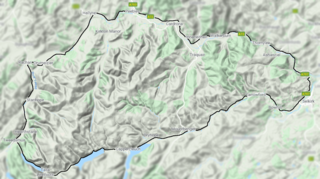
The Manor Hills, also known as the Tweedsmuir Hills, are a range of hills south of Peebles in the Scottish Borders, one of the ranges which collectively form the Southern Uplands. They are separated from the Moffat Hills by the Talla Reservoir, Megget Reservoir and St. Mary's Loch, the Moorfoot Hills by the A72 and the Culter Hills in South Lanarkshire by the A701. The western portion of the hills are designated as the 'Tweedsmuir Hills' Site of Special Scientific Interest and the 'Upper Tweeddale' National Scenic Area, with the major tributary rivers designated as Special Areas of Conservation.
Swatte Fell is a hill in the Moffat Hills range, part of the Southern Uplands of Scotland. It lies north of the town of Moffat in Dumfries and Galloway, south of its parent peak, Hart Fell. It is gently sloping on three sides of the hill, however the east ridge is steep and craggy and features a deep corrie known as Blackhope, from which a popular rock climb, the Coomb Craig ridge, originates, finishing near the summit, and was featured on the OS Explorer 330 map front cover. The normal route is from the southern ridge and can be extended to include a full loop of Blackhope, finishing on Saddle Yoke, known as the Hart Fell Horseshoe.

Black Law is a hill in the Manor Hills range, part of the Southern Uplands of Scotland. One of the more remote Donalds, it does not easily combine into a round with other hills in the area and requires traversing rough terrain to reach the top. Common ascents are as part of an extended Dun Rig Horseshoe to the north-east, from the south at the Megget Reservoir or, most easily, from the Manor Valley itself.

Meaul is a hill in the Rhinns of Kells, a sub-range of the Galloway Hills range, part of the Southern Uplands of Scotland. It is climbed from a number of directions; most commonly from Garryhorn near Carsphairn, often as part of a complete traverse of the ridge.

Andrewhinney Hill is a hill in the Ettrick Hills range, part of the Southern Uplands of Scotland. It is the highest summit of a ridge that runs parallel to the A708 road on its southern side, with the Grey Mare's Tail in the Moffat Hills directly opposite. The northwestern slopes are designated as part of the 'Moffat Hills' SSSI and SAC.

Wind Fell is a hill in the Ettrick Hills range, part of the Southern Uplands of Scotland. The Dumfries and Galloway-Scottish Borders border lies across the hill. Close to the Southern Upland Way, routes of ascent frequently incorporate its track and it is almost always climbed along with the neighbouring hills.

Whitehope Heights is a hill in the Moffat Hills range, part of the Southern Uplands of Scotland. The lowest Donald hill in the range, it is separated from Hart Fell by a steep grassy cleuch known as The Gyle. Like its neighbour, the Dumfries and Galloway-Scottish Borders border runs along its summit. The southern slopes of the hill are part of the Corehead hill farm, an area owned by the Borders Forest Trust for the purposes of habitat regeneration; as a result, a large deer fence lines the boundary. East of the Devil's Beef Tub and Annandale Way, it is most frequently climbed from this direction, but ascents from Hart Fell are also common.

The Ettrick Hills are a range of hills that are part of the Southern Uplands of Scotland. They are neighboured to the northwest by the Moffat Hills and are located mainly within the Scottish Borders; however, the Dumfries and Galloway border covers the south and southwesterly flanks.

